
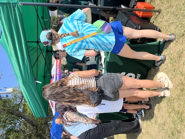
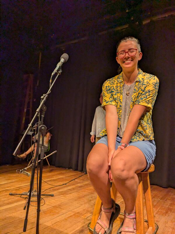
Marie Bartlett at the 2025 Woods Hole Science Stroll on August 9, 2025. During this free event, a variety of booths line the streets, docks, and Waterfront Park to deliver hands-on science activities, games, demonstrations, and more to visitors of all ages.
Images
Woods Hole Coastal and Marine Science Center images
Filter Total Items: 1298
2025 Woods Hole Science Stroll
Marie Bartlett at the 2025 Woods Hole Science Stroll on August 9, 2025. During this free event, a variety of booths line the streets, docks, and Waterfront Park to deliver hands-on science activities, games, demonstrations, and more to visitors of all ages.
2025 Woods Hole Science Stroll
Brita Jessen and Eric Moore at the earthquake station at the 2025 Woods Hole Science Stroll on August 9, 2025. We setup a shake table that moves in different directions, at varying frequencies to demonstrate the power of earthquakes.
Brita Jessen and Eric Moore at the earthquake station at the 2025 Woods Hole Science Stroll on August 9, 2025. We setup a shake table that moves in different directions, at varying frequencies to demonstrate the power of earthquakes.
2025 Woods Hole Science Stroll
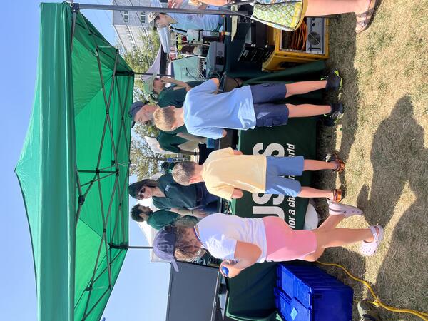
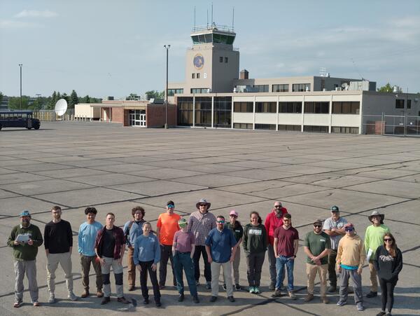
USGS at the 2025 Woods Hole Science Stroll on August 9, 2025! This year's participants included Meagan Eagle, Eric Moore, Zafer Defne, Marie Bartlett, Sara Ernst, Amit Millo, Seth Ackerman, Brita Jessen, and Alfredo Aretxabaleta.
USGS at the 2025 Woods Hole Science Stroll on August 9, 2025! This year's participants included Meagan Eagle, Eric Moore, Zafer Defne, Marie Bartlett, Sara Ernst, Amit Millo, Seth Ackerman, Brita Jessen, and Alfredo Aretxabaleta.
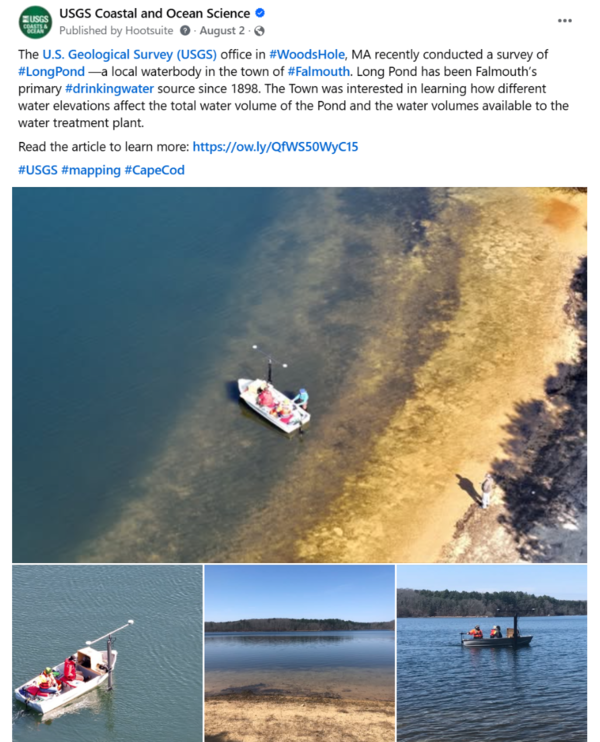
Social Media: Long Pond mapping survey
The USGS office in Woods Hole, MA recently conducted a survey of Long Pond—a local waterbody in the town of Falmouth. Long Pond has been Falmouth’s primary drinking water source since 1898.
The USGS office in Woods Hole, MA recently conducted a survey of Long Pond—a local waterbody in the town of Falmouth. Long Pond has been Falmouth’s primary drinking water source since 1898.
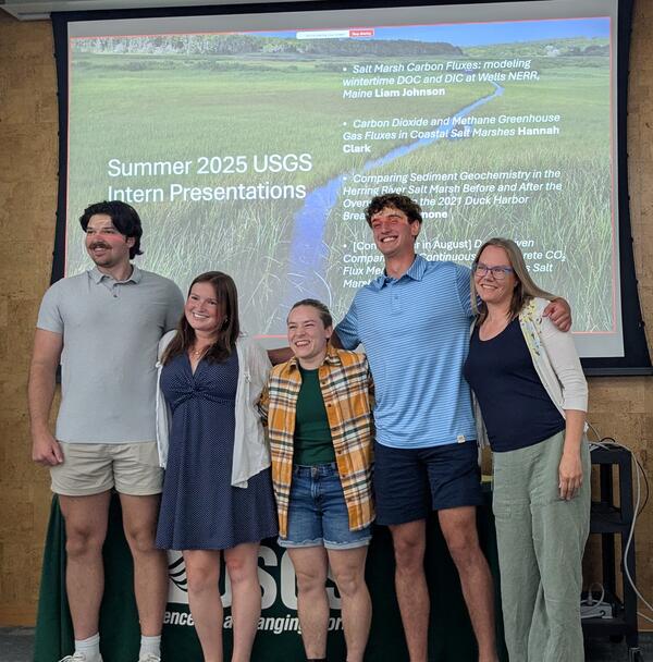
Summer 2025 Internship Presentations
In August, the Woods Hole Coastal and Marine Science Center had four great presentations from summer interns discussing various aspects of salt marsh science!
In August, the Woods Hole Coastal and Marine Science Center had four great presentations from summer interns discussing various aspects of salt marsh science!
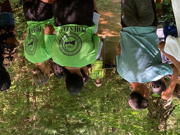
EPA/USGS Day of the 2025 Mashpee Wampanoag Tribe - Preserving Our Homelands Summer Camp
EPA/USGS Day of the 2025 Mashpee Wampanoag Tribe - Preserving Our Homelands Summer CampThe Environmental Protection Agency (EPA) and USGS prepared four activities for the Preserving Our Homelands Summer Camp on July 22nd. EPA hosted an air quality monitoring activity that involved the campers conducting tests and participating in a guided discussion about factors contributing to air quality and its implications on people and habitat.
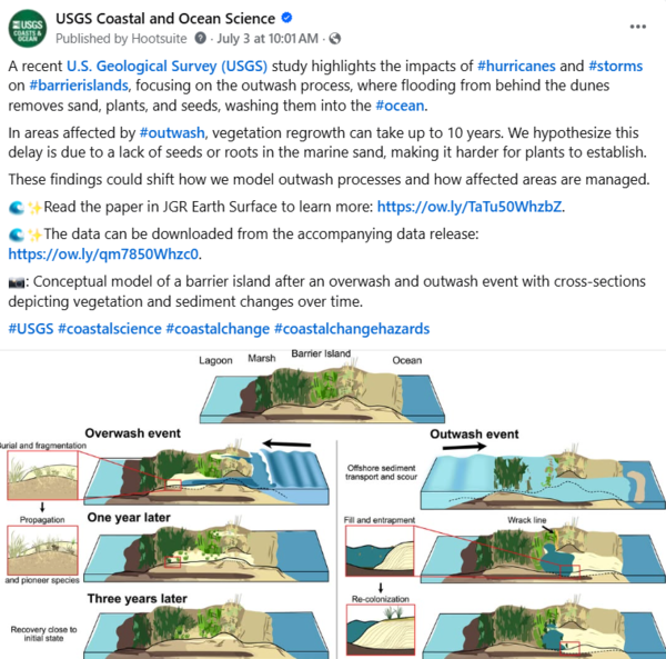
Social media for barrier island study
A recent USGS study highlights the impacts of #hurricanes and #storms on #barrierislands, focusing on the outwash process, where flooding from behind the dunes removes sand, plants, and seeds, washing them into the #ocean.
A recent USGS study highlights the impacts of #hurricanes and #storms on #barrierislands, focusing on the outwash process, where flooding from behind the dunes removes sand, plants, and seeds, washing them into the #ocean.
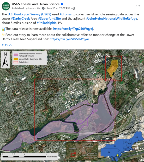
Social media for Superfund Site drone survey
The USGS used #drones to collect aerial remote sensing data across the Lower #DarbyCreek Area Superfund Site and the adjacent #JohnHeinzNationalWildlifeRefuge, about 5 miles outside of #Philadelphia, PA. The data release is now available: https://doi.org/10.5066/P134HU3Y.
The USGS used #drones to collect aerial remote sensing data across the Lower #DarbyCreek Area Superfund Site and the adjacent #JohnHeinzNationalWildlifeRefuge, about 5 miles outside of #Philadelphia, PA. The data release is now available: https://doi.org/10.5066/P134HU3Y.
Social media for CRL model
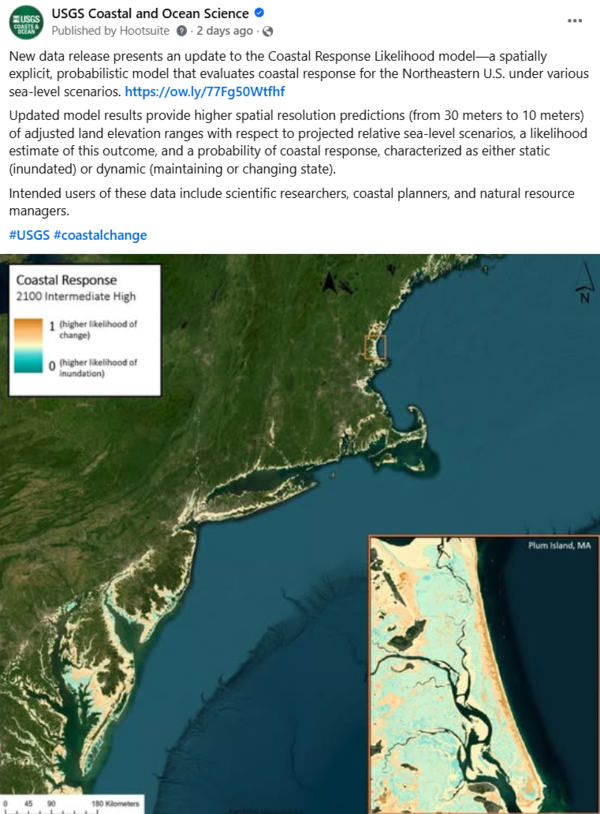
New data release presents an update to the Coastal Response Likelihood model—a spatially explicit, probabilistic model that evaluates coastal response for the Northeastern U.S. under various sea-level scenarios. https://doi.org/10.5066/P13JKJUT
New data release presents an update to the Coastal Response Likelihood model—a spatially explicit, probabilistic model that evaluates coastal response for the Northeastern U.S. under various sea-level scenarios. https://doi.org/10.5066/P13JKJUT

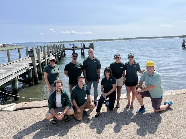
Mapping Nantucket Sound
Preparing equipment to map the geologic framework of Nantucket Sound, offshore Cape Cod, Massachusetts.
Preparing equipment to map the geologic framework of Nantucket Sound, offshore Cape Cod, Massachusetts.
Social media for seafloor mapping article
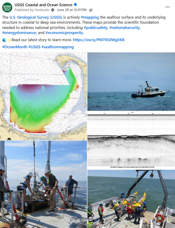
The USGS is actively mapping the seafloor surface and its underlying structure in coastal to deep sea environments. These maps provide the scientific foundation needed to address national priorities, including #publicsafety, #nationalsecurity, #energydominance, and #economicprosperity.
The USGS is actively mapping the seafloor surface and its underlying structure in coastal to deep sea environments. These maps provide the scientific foundation needed to address national priorities, including #publicsafety, #nationalsecurity, #energydominance, and #economicprosperity.
Science Storytelling
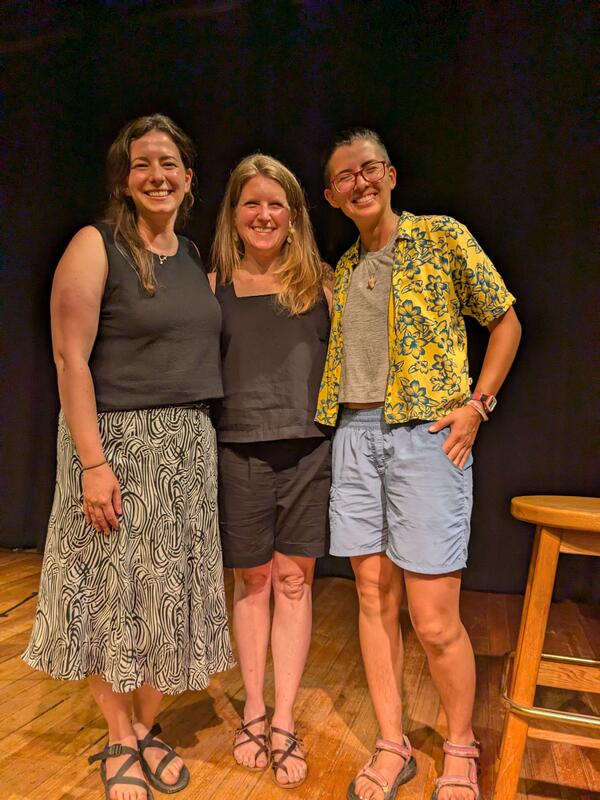
Non-profit organizations Transom Story Lab and Atlantic Public Media hosted a weekend-long science storytelling workshop called "Making Waves." It was attended by 11 scientists from scientific institutions throughout Woods Hole, Massachusetts, including USGS scientists Jin-Si Over, Ellen Lalk, and Sara Zeigler.
Non-profit organizations Transom Story Lab and Atlantic Public Media hosted a weekend-long science storytelling workshop called "Making Waves." It was attended by 11 scientists from scientific institutions throughout Woods Hole, Massachusetts, including USGS scientists Jin-Si Over, Ellen Lalk, and Sara Zeigler.
Social media for treasure maps article
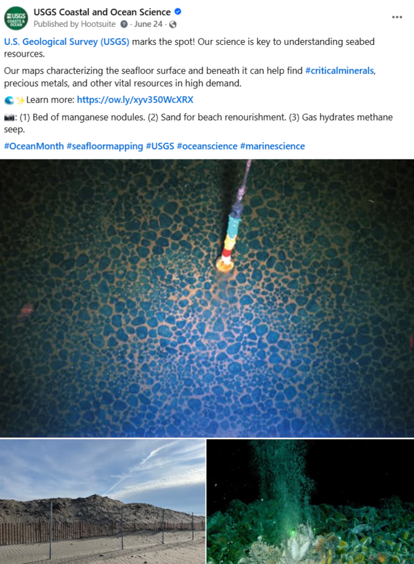
USGS marks the spot! Our science is key to understanding seabed resources. Our maps characterizing the seafloor can help find #criticalminerals, precious metals, and other vital resources in high demand.
USGS marks the spot! Our science is key to understanding seabed resources. Our maps characterizing the seafloor can help find #criticalminerals, precious metals, and other vital resources in high demand.
Science Storytelling
Non-profit organizations Transom Story Lab and Atlantic Public Media hosted a weekend-long science storytelling workshop called "Making Waves." It was attended by 11 scientists from scientific institutions throughout Woods Hole, Massachusetts, including USGS scientists Jin-Si Over, Ellen Lalk, and Sara Zeigler.
Non-profit organizations Transom Story Lab and Atlantic Public Media hosted a weekend-long science storytelling workshop called "Making Waves." It was attended by 11 scientists from scientific institutions throughout Woods Hole, Massachusetts, including USGS scientists Jin-Si Over, Ellen Lalk, and Sara Zeigler.
Drone pilot course
An introductory course for small uncrewed aircraft system (sUAS) pilots was held at the New York State Emergency Preparedness Training Facility in Oriskany, New York. Instructors from across the country, including Sandy Brosnahan (lead instructor) and Seth Ackerman of the USGS WHCMSC, collaborated to deliver the training.
An introductory course for small uncrewed aircraft system (sUAS) pilots was held at the New York State Emergency Preparedness Training Facility in Oriskany, New York. Instructors from across the country, including Sandy Brosnahan (lead instructor) and Seth Ackerman of the USGS WHCMSC, collaborated to deliver the training.

Secrets of the Seep documentary
WFSU produced a documentary covering a research cruise offshore Oregon to Astoria Canyon (2023) and smaller campaigns to the Hydrate Ridge seep system (2024) to study the cycling dynamics of dissolved organic matter at methane seeps.
WFSU produced a documentary covering a research cruise offshore Oregon to Astoria Canyon (2023) and smaller campaigns to the Hydrate Ridge seep system (2024) to study the cycling dynamics of dissolved organic matter at methane seeps.

USGS Long Island Sound Webinar
The USGS hosted a webinar highlighting new USGS tools developed for use in Long Island Sound.
The USGS hosted a webinar highlighting new USGS tools developed for use in Long Island Sound.

Secrets of the Seep documentary
WFSU produced a documentary covering a research cruise offshore Oregon to Astoria Canyon (2023) and smaller campaigns to the Hydrate Ridge seep system (2024) to study the cycling dynamics of dissolved organic matter at methane seeps.
WFSU produced a documentary covering a research cruise offshore Oregon to Astoria Canyon (2023) and smaller campaigns to the Hydrate Ridge seep system (2024) to study the cycling dynamics of dissolved organic matter at methane seeps.

Long Island Sound SEABOSS Survey
A seafloor mapping survey in Long Island Sound took place in May with collaborators from the University of Connecticut and the University of New Haven. They are mapping the area’s geology and biota to identify seasonal changes from their previous survey in November 2024.
A seafloor mapping survey in Long Island Sound took place in May with collaborators from the University of Connecticut and the University of New Haven. They are mapping the area’s geology and biota to identify seasonal changes from their previous survey in November 2024.

Coastal Landscape Response
The Coastal Landscape Response assessment creates multidecadal predictions of where and when the coast is likely to adapt or inundate. Results are produced for four decades—the 2020s, 2030s, 2050s, and 2080s.
The Coastal Landscape Response assessment creates multidecadal predictions of where and when the coast is likely to adapt or inundate. Results are produced for four decades—the 2020s, 2030s, 2050s, and 2080s.

CCL Outcomes for Wallops Joint Expeditionary Base
USGS Coastal Change Likelihood (CCL) outcomes are displayed for Wallops Joint Expeditionary Base in Virginia. Warm colors indicate areas of high expected coastal change and cool colors indicate areas with lower expected change.
USGS Coastal Change Likelihood (CCL) outcomes are displayed for Wallops Joint Expeditionary Base in Virginia. Warm colors indicate areas of high expected coastal change and cool colors indicate areas with lower expected change.