U.S. flag

An official website of the United States government

Ocean Resources

USGS conducts research studies focused on geologic mapping, sampling and understanding of mineral and energy resources and studies of the geologic setting and processes to inform renewable energy development offshore.  Resources of high interest and value are gas hydrates, renewable kinetic energy in offshore winds, tides and currents, deposits of rare earth elements, and sand and gravel deposits.

Filter Total Items: 14

USGS Law of the Sea

The USGS Law of the Sea project helps to determine the outer limits of the extended continental shelf (ECS) of the United States. The ECS is that portion of the continental shelf beyond 200 nautical miles. It is an important maritime zone that holds many resources and vital habitats for marine life. Its size may exceed one million square kilometers, encompassing areas in the Arctic, Atlantic...
link

USGS Law of the Sea

The USGS Law of the Sea project helps to determine the outer limits of the extended continental shelf (ECS) of the United States. The ECS is that portion of the continental shelf beyond 200 nautical miles. It is an important maritime zone that holds many resources and vital habitats for marine life. Its size may exceed one million square kilometers, encompassing areas in the Arctic, Atlantic...
Learn More

Woods Hole Coastal and Marine Science Center 2020 Annual Report

The U.S. Geological Survey (USGS) Woods Hole Coastal and Marine Science Center in Woods Hole, Massachusetts, is one of three centers serving the mission of the USGS Coastal/Marine Hazards and Resources Program (CMHRP). Since its authorization by Congress in 1962, the CMHRP has served as the primary Federal program for marine geology and physical science research.
link

Woods Hole Coastal and Marine Science Center 2020 Annual Report

The U.S. Geological Survey (USGS) Woods Hole Coastal and Marine Science Center in Woods Hole, Massachusetts, is one of three centers serving the mission of the USGS Coastal/Marine Hazards and Resources Program (CMHRP). Since its authorization by Congress in 1962, the CMHRP has served as the primary Federal program for marine geology and physical science research.
Learn More

Searching for Faults From Afar

For our project, the R/V Marcus G. Langseth is towing a 12-kilometer-long hydrophone streamer that records sound reflected from deep below the seafloor , which is helping scientists image the structure of the Cascadia Subduction Zone and megathrust fault. The streamer records data as a function of the time it takes for sound to travel from the ship’s source down to “reflectors”
link

Searching for Faults From Afar

For our project, the R/V Marcus G. Langseth is towing a 12-kilometer-long hydrophone streamer that records sound reflected from deep below the seafloor , which is helping scientists image the structure of the Cascadia Subduction Zone and megathrust fault. The streamer records data as a function of the time it takes for sound to travel from the ship’s source down to “reflectors”
Learn More

Stellwagen Bank National Marine Sanctuary Geologic Mapping

These field activity data releases, publications, and maps are part of the combined effort by the U.S. Geological Survey and NOAA’s Stellwagen Bank National Marine Sanctuary to map the geologic substrates of Stellwagen Bank and to study the ecology of fish and invertebrate species that inhabit the bank’s sandy substrates off Boston, Massachusetts.
link

Stellwagen Bank National Marine Sanctuary Geologic Mapping

These field activity data releases, publications, and maps are part of the combined effort by the U.S. Geological Survey and NOAA’s Stellwagen Bank National Marine Sanctuary to map the geologic substrates of Stellwagen Bank and to study the ecology of fish and invertebrate species that inhabit the bank’s sandy substrates off Boston, Massachusetts.
Learn More

Seeking the Seeps

From June 12 to July 3, 2019, the USGS sailed onboard Schmidt Ocean Institute’s R/V Falkor with several other partners, seeking methane seeps along the seafloor of several underwater canyons off the coast of Oregon and Washington. On this cruise, USGS scientists will seek to understand how much methane is coming out of these seeps, how it travels through the water column, and its ultimate fate in...
link

Seeking the Seeps

From June 12 to July 3, 2019, the USGS sailed onboard Schmidt Ocean Institute’s R/V Falkor with several other partners, seeking methane seeps along the seafloor of several underwater canyons off the coast of Oregon and Washington. On this cruise, USGS scientists will seek to understand how much methane is coming out of these seeps, how it travels through the water column, and its ultimate fate in...
Learn More

Woods Hole Coastal and Marine Science Center Employment Opportunities

Join the Woods Hole Coastal and Marine Science Center team! The Center is part of the USGS Coastal/Marine Hazards and Resources Program, which is the primary federal marine geology and physical science research program. The Center's staff of 100 provides scientific information that contributes to decisions by other federal agencies, state and local entities, private organizations, industry, and...
link

Woods Hole Coastal and Marine Science Center Employment Opportunities

Join the Woods Hole Coastal and Marine Science Center team! The Center is part of the USGS Coastal/Marine Hazards and Resources Program, which is the primary federal marine geology and physical science research program. The Center's staff of 100 provides scientific information that contributes to decisions by other federal agencies, state and local entities, private organizations, industry, and...
Learn More

USGS Woods Hole Coastal and Marine Science Center Samples Repository

Since 2002, the Woods Hole Coastal and Marine Science Center’s Samples Repository (WHCMSC) has been supporting research by providing secure storage for geological, biological, and geochemical samples; maintaining organization and an active inventory of these sample collections; as well as by providing access to these collections for study and reuse. Over the years, local storage facilities have...
link

USGS Woods Hole Coastal and Marine Science Center Samples Repository

Since 2002, the Woods Hole Coastal and Marine Science Center’s Samples Repository (WHCMSC) has been supporting research by providing secure storage for geological, biological, and geochemical samples; maintaining organization and an active inventory of these sample collections; as well as by providing access to these collections for study and reuse. Over the years, local storage facilities have...
Learn More

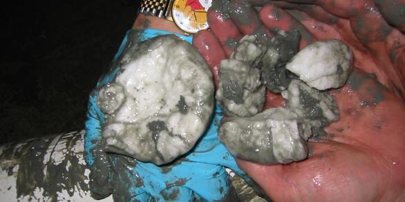
U.S. Geological Survey Gas Hydrates Project

The USGS Gas Hydrates Project has been making contributions to advance understanding of US and international gas hydrates science for at least three decades. The research group working on gas hydrates at the USGS is among the largest in the US and has expertise in all the major geoscience disciplines, as well as in the physics and chemistry of gas hydrates, the geotechnical properties of hydrate...
link

U.S. Geological Survey Gas Hydrates Project

The USGS Gas Hydrates Project has been making contributions to advance understanding of US and international gas hydrates science for at least three decades. The research group working on gas hydrates at the USGS is among the largest in the US and has expertise in all the major geoscience disciplines, as well as in the physics and chemistry of gas hydrates, the geotechnical properties of hydrate...
Learn More

Sea Floor Mapping Group

The Sea Floor Mapping Group (SFMG) is a core capability at the Woods Hole Coastal & Marine Science Center (WHCMSC) that provides support for coastal, lacustrine and marine geologic research. The staff has a wide-range of expertise and is responsible for geophysical and sampling data acquisition, processing, interpretation and publication, logistics, design, and research and development. SFMG has...
link

Sea Floor Mapping Group

The Sea Floor Mapping Group (SFMG) is a core capability at the Woods Hole Coastal & Marine Science Center (WHCMSC) that provides support for coastal, lacustrine and marine geologic research. The staff has a wide-range of expertise and is responsible for geophysical and sampling data acquisition, processing, interpretation and publication, logistics, design, and research and development. SFMG has...
Learn More

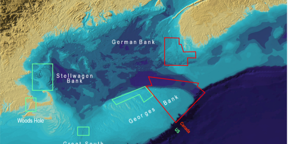
National Seafloor Mapping and Benthic Habitat Studies

The Stellwagen Bank region, located off Boston, Massachusetts, just east of Massachusetts Bay between Cape Cod and Cape Ann, is a glaciated terrain of shallow banks and deep basins with water depths ranging from 20 to 200 meters. The region is heavily utilized by humans and marine species. It serves as a National Marine Sanctuary; a rich commercial and recreational fishing ground; a disposal site...
link

National Seafloor Mapping and Benthic Habitat Studies

The Stellwagen Bank region, located off Boston, Massachusetts, just east of Massachusetts Bay between Cape Cod and Cape Ann, is a glaciated terrain of shallow banks and deep basins with water depths ranging from 20 to 200 meters. The region is heavily utilized by humans and marine species. It serves as a National Marine Sanctuary; a rich commercial and recreational fishing ground; a disposal site...
Learn More

The Mid-Atlantic Resource Imaging Experiment (MATRIX)

In late August 2018, scientists and technical staff from the USGS Coastal and Marine Hazards and Resources Program completed the acquisition of over 2000 km of multichannel seismic (MCS) data as part of the Mid-Atlantic Resource Imaging Experiment (MATRIX) conducted aboard the R/V Hugh R. Sharp . The seismic program was led by the USGS Gas Hydrates Project and was sponsored by the USGS, the U.S...
link

The Mid-Atlantic Resource Imaging Experiment (MATRIX)

In late August 2018, scientists and technical staff from the USGS Coastal and Marine Hazards and Resources Program completed the acquisition of over 2000 km of multichannel seismic (MCS) data as part of the Mid-Atlantic Resource Imaging Experiment (MATRIX) conducted aboard the R/V Hugh R. Sharp . The seismic program was led by the USGS Gas Hydrates Project and was sponsored by the USGS, the U.S...
Learn More

Analytical Facilities

The Core Laboratories Project is a research support service of the WHCMSC which provides analytical and technical infrastructure, and supports of a range of projects associated with Coastal Biogeochemical Processes, Coastal Groundwater, and Sedimentology.
link

Analytical Facilities

The Core Laboratories Project is a research support service of the WHCMSC which provides analytical and technical infrastructure, and supports of a range of projects associated with Coastal Biogeochemical Processes, Coastal Groundwater, and Sedimentology.
Learn More
Was this page helpful?