
A juvenile common loon wearing a satellite transmitter antenna follows an adult.
Images
Images
Filter Total Items: 9448

Radiomarked Common Loon
A juvenile common loon wearing a satellite transmitter antenna follows an adult.

Rock Riffle and Water Flow in Sonoma Creek
Increased flow over rock riffle in Sonoma Creek seen after South Napa Earthquake of August 24, 2014.
Location: Sonoma Creek downstream of the Agua Caliente Road Bridge, Sonoma County, California.
Increased flow over rock riffle in Sonoma Creek seen after South Napa Earthquake of August 24, 2014.
Location: Sonoma Creek downstream of the Agua Caliente Road Bridge, Sonoma County, California.

Fire Coral Bleaching
Colonies of “blade fire coral” that have lost their symbiotic algae, or “bleached,” on a reef off of Islamorada, Florida. Hard and soft corals are presently bleaching- losing their symbiotic algae – all over the coral reefs of the Florida Keys due to unusually warm ocean temperatures this summer.
Colonies of “blade fire coral” that have lost their symbiotic algae, or “bleached,” on a reef off of Islamorada, Florida. Hard and soft corals are presently bleaching- losing their symbiotic algae – all over the coral reefs of the Florida Keys due to unusually warm ocean temperatures this summer.

Bent Sea Rod Bleaching
A colony of the soft coral known as the "bent sea rod" stands bleached on a reef off of Islamorada, Florida. Hard and soft corals are presently bleaching- losing their symbiotic algae – all over the coral reefs of the Florida Keys due to unusually warm ocean temperatures this summer.
A colony of the soft coral known as the "bent sea rod" stands bleached on a reef off of Islamorada, Florida. Hard and soft corals are presently bleaching- losing their symbiotic algae – all over the coral reefs of the Florida Keys due to unusually warm ocean temperatures this summer.

Brain Coral Bleaching
No, that is not a mound of snow sitting on a coral reef – it is a colony of bleached "brain coral" on a reef off of Islamorada, Florida. Hard and soft corals are presently bleaching- losing their symbiotic algae – all over the coral reefs of the Florida Keys due to unusually warm ocean temperatures this summer.
No, that is not a mound of snow sitting on a coral reef – it is a colony of bleached "brain coral" on a reef off of Islamorada, Florida. Hard and soft corals are presently bleaching- losing their symbiotic algae – all over the coral reefs of the Florida Keys due to unusually warm ocean temperatures this summer.

Panorama of Mississippi River Bend at Algiers Point
Panorama of Mississippi River Bend at Algiers PointA panorama of the Mississippi River as it winds its way past Algiers Point in New Orleans. To the left of the image can be seen the French Quarter, while to the right can be seen Algiers Point.
Panorama of Mississippi River Bend at Algiers Point
Panorama of Mississippi River Bend at Algiers PointA panorama of the Mississippi River as it winds its way past Algiers Point in New Orleans. To the left of the image can be seen the French Quarter, while to the right can be seen Algiers Point.

St. Charles Streetcar
The iconic St. Charles streetcar as it begins its route at Canal St.
The iconic St. Charles streetcar as it begins its route at Canal St.

New Orleans Central Business District
A view upstream along the Mississippi River of the Central Business District of New Orleans.
A view upstream along the Mississippi River of the Central Business District of New Orleans.

St. Charles Avenue from the Streetcar
A view of St. Charles Avenue from the St. Charles Streetcar, outbound through New Orleans.
A view of St. Charles Avenue from the St. Charles Streetcar, outbound through New Orleans.

Streetcar Interior
The interior of a St. Charles Streetcar.
The interior of a St. Charles Streetcar.

Mississippi River Bend at Algiers Point
A view of the Mississippi River as it winds its way past Algiers Point in New Orleans. To the left of the image can be seen the French Quarter, while to the right can be seen Algiers Point.
A view of the Mississippi River as it winds its way past Algiers Point in New Orleans. To the left of the image can be seen the French Quarter, while to the right can be seen Algiers Point.

Wildfire and Alaskan Permafrost
Deploying geophysical equipment in the Nome Creek (AK) area to assess the effect of wildfire on permafrost. Small electrical signals are injected into the ground through metal stakes connected to the orange cable in the foreground. The measured response is used to detect belowground permafrost conditions.
Deploying geophysical equipment in the Nome Creek (AK) area to assess the effect of wildfire on permafrost. Small electrical signals are injected into the ground through metal stakes connected to the orange cable in the foreground. The measured response is used to detect belowground permafrost conditions.

Oncoming Streetcar
An oncoming St. Charles Streetcar picks up passengers in the Garden District on its way back into New Orleans.
An oncoming St. Charles Streetcar picks up passengers in the Garden District on its way back into New Orleans.

Streetcars at Claiborne and Carrollton
St. Charles Streetcars at their outbound terminus, the intersection of Carrollton and Claiborne Avenues.
St. Charles Streetcars at their outbound terminus, the intersection of Carrollton and Claiborne Avenues.

Algiers Point
Algiers Point can be seen here, one of the many bends the Mississippi River makes as it flows to the Gulf of Mexico.
Algiers Point can be seen here, one of the many bends the Mississippi River makes as it flows to the Gulf of Mexico.

In Route to Sampling Station
USGS scientists (from left) Judy Drexler, Brian Bergamaschi, Tamara Kraus, Bryan Downing and Katy O’Donnell in route to a sampling station aboard the USGS R/V Mary Landsteiner.
Location: Northern San Francisco Estuary, CA
USGS scientists (from left) Judy Drexler, Brian Bergamaschi, Tamara Kraus, Bryan Downing and Katy O’Donnell in route to a sampling station aboard the USGS R/V Mary Landsteiner.
Location: Northern San Francisco Estuary, CA

Natural Gas Flare
A natural gas flare. Sometimes, often due to lack of transportation or storage capacity, natural gas that is co-produced with oil will be burned in a flare. This wellpad is in the Tuscaloosa Marine Shale.
A natural gas flare. Sometimes, often due to lack of transportation or storage capacity, natural gas that is co-produced with oil will be burned in a flare. This wellpad is in the Tuscaloosa Marine Shale.
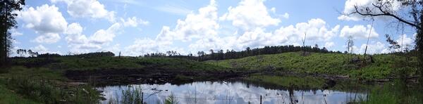
Panorama of Clear-Cutting for Pulp Mill
A panorama view of an area clear-cut of pine trees for processing at a pulp mill. Pulp mills manufacture paper from wood.
A panorama view of an area clear-cut of pine trees for processing at a pulp mill. Pulp mills manufacture paper from wood.
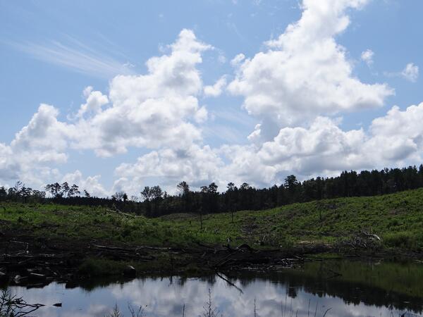
Clear-Cutting for Pulp Mill
A view of an area clear-cut of pine trees for processing at a pulp mill. Pulp mills manufacture paper from wood.
A view of an area clear-cut of pine trees for processing at a pulp mill. Pulp mills manufacture paper from wood.

USGS Scientists Taking Field Measurements
USGS scientists (from left) Judy Drexler, Tamara Kraus and Bryan Downing and Katy O’Donnell preparing to take spot field measurements in the San Francisco estuary.
Location: Northern San Francisco Estuary, CA
USGS scientists (from left) Judy Drexler, Tamara Kraus and Bryan Downing and Katy O’Donnell preparing to take spot field measurements in the San Francisco estuary.
Location: Northern San Francisco Estuary, CA

Calibrating Real-time Measurements
The USGS R/V Mary Landsteiner shown at a brief stop during a study in the Northern San Francisco estuary. USGS scientist Bryan Downing is shown calibrating the on-board real-time underway measurement system.
Location: Northern San Francisco Estuary, CA
The USGS R/V Mary Landsteiner shown at a brief stop during a study in the Northern San Francisco estuary. USGS scientist Bryan Downing is shown calibrating the on-board real-time underway measurement system.
Location: Northern San Francisco Estuary, CA