
A USGS South Dakota Water Science Center streamgage was dedicated by Congressional and city officials on September 3 in Rapid City.
Images
Images
Filter Total Items: 9448

Tools of the Water Science Trade
A USGS South Dakota Water Science Center streamgage was dedicated by Congressional and city officials on September 3 in Rapid City.

Display Window on Showcase Streamgage
A USGS South Dakota Water Science Center streamgage was dedicated by Congressional and city officials on September 3 in Rapid City.
A USGS South Dakota Water Science Center streamgage was dedicated by Congressional and city officials on September 3 in Rapid City.

Showcase Streamgage at Trailhead
A USGS South Dakota Water Science Center streamgage was dedicated by Congressional and city officials on September 3 in Rapid City.
A USGS South Dakota Water Science Center streamgage was dedicated by Congressional and city officials on September 3 in Rapid City.

Rapid City, SD Showcase Streamgage
A USGS South Dakota Water Science Center streamgage was dedicated by Congressional and city officials on September 3 in Rapid City.
A USGS South Dakota Water Science Center streamgage was dedicated by Congressional and city officials on September 3 in Rapid City.

Rapid City, SD Showcase Streamgage
A USGS South Dakota Water Science Center streamgage was dedicated by Congressional and city officials on September 3 in Rapid City.
A USGS South Dakota Water Science Center streamgage was dedicated by Congressional and city officials on September 3 in Rapid City.

USGS South Dakota Water Science Center
The USGS South Dakota Water Science Center is located in Rapid City, SD.
The USGS South Dakota Water Science Center is located in Rapid City, SD.
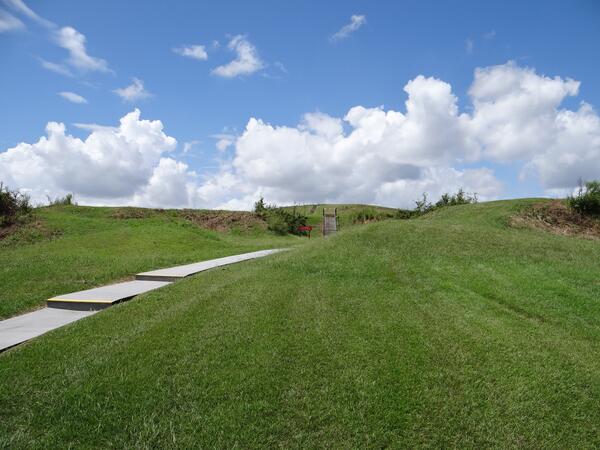
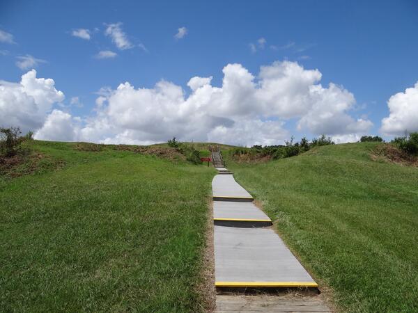
Stairs Ascending Mound A
The stairs ascending Mound A from the east. Mound A is also known as the "Bird Mound," because its original shape is believed to have been that of a bird. The stairs climb from the legs and tail of the bird toward its head.
The stairs ascending Mound A from the east. Mound A is also known as the "Bird Mound," because its original shape is believed to have been that of a bird. The stairs climb from the legs and tail of the bird toward its head.
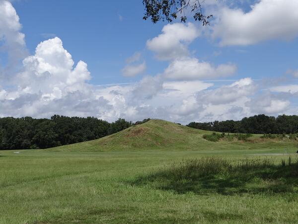
View of Mound A
View of the primary mound, Mound A, looking north. Mound A is also known as the "Bird Mound," because its original shape is believed to have been that of a bird.
View of the primary mound, Mound A, looking north. Mound A is also known as the "Bird Mound," because its original shape is believed to have been that of a bird.
Crest of Mound A Looking South
A view from the crest of Mound A to the south. Mound A is also known as the "Bird Mound," because its original shape is believed to have been that of a bird. This view is of its left wing, looking towards Mound E, which can be seen at the edge of the green field.
A view from the crest of Mound A to the south. Mound A is also known as the "Bird Mound," because its original shape is believed to have been that of a bird. This view is of its left wing, looking towards Mound E, which can be seen at the edge of the green field.

Close Up of Grizzly Bear Hair on Fence
Grizzly bear hair on barbed wire at a hair corral. Bears climb over or under the corral and the hair collected provides information for genetic analysis.
Grizzly bear hair on barbed wire at a hair corral. Bears climb over or under the corral and the hair collected provides information for genetic analysis.
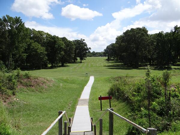
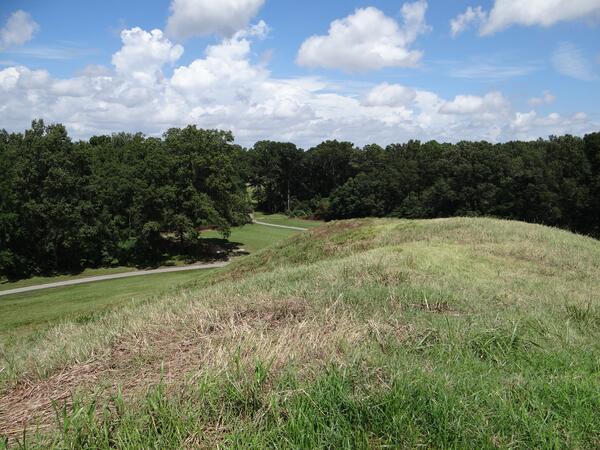
View from Mound A to the East
The stairs descending Mound A to the east. Mound A is also known as the "Bird Mound," because its original shape is believed to have been that of a bird. Mound A is at the apex of a series of 6 concentric rings of raised earthworks. The rings were believed to have been the site of dwellings.
The stairs descending Mound A to the east. Mound A is also known as the "Bird Mound," because its original shape is believed to have been that of a bird. Mound A is at the apex of a series of 6 concentric rings of raised earthworks. The rings were believed to have been the site of dwellings.
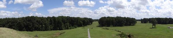
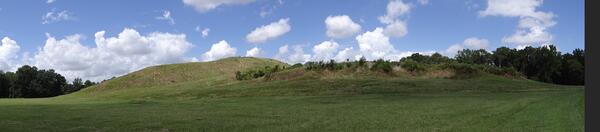
Panorama of View from Mound A to the East
A panorama of the stairs descending Mound A to the east. Mound A is also known as the "Bird Mound," because its original shape is believed to have been that of a bird. Mound A is at the apex of a series of 6 concentric rings of raised earthworks. The rings were believed to have been the site of dwellings.
A panorama of the stairs descending Mound A to the east. Mound A is also known as the "Bird Mound," because its original shape is believed to have been that of a bird. Mound A is at the apex of a series of 6 concentric rings of raised earthworks. The rings were believed to have been the site of dwellings.

View of Mound A
View of the primary mound, Mound A, looking northwest. Mound A is also known as the "Bird Mound," because its original shape is believed to have been that of a bird.
View of the primary mound, Mound A, looking northwest. Mound A is also known as the "Bird Mound," because its original shape is believed to have been that of a bird.
Stairs Ascending Mound A
The stairs ascending Mound A from the east. Mound A is also known as the "Bird Mound," because its original shape is believed to have been that of a bird. The stairs climb from the legs and tail of the bird toward its head.
The stairs ascending Mound A from the east. Mound A is also known as the "Bird Mound," because its original shape is believed to have been that of a bird. The stairs climb from the legs and tail of the bird toward its head.
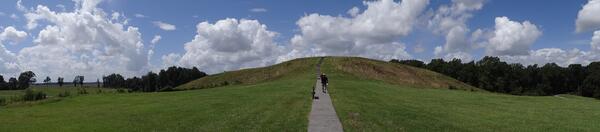
Panorama of Mound A
A panorama of the stairs ascending Mound A from the east. Mound A is also known as the "Bird Mound," because its original shape is believed to have been that of a bird. The stairs climb from the legs and tail of the bird toward its head.
A panorama of the stairs ascending Mound A from the east. Mound A is also known as the "Bird Mound," because its original shape is believed to have been that of a bird. The stairs climb from the legs and tail of the bird toward its head.
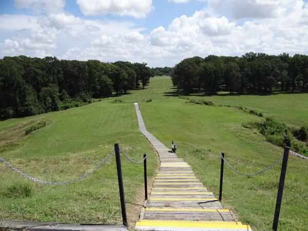
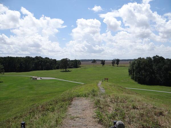
Crest of Mound A Looking East
A view from the crest of Mound A of the stairs descending to the east. Mound A is also known as the "Bird Mound," because its original shape is believed to have been that of a bird. Mound A is at the apex of a series of 6 concentric rings of raised earthworks. The rings were believed to have been the site of dwellings.
A view from the crest of Mound A of the stairs descending to the east. Mound A is also known as the "Bird Mound," because its original shape is believed to have been that of a bird. Mound A is at the apex of a series of 6 concentric rings of raised earthworks. The rings were believed to have been the site of dwellings.
Panorama of Mound A
Panorama of the primary mound, Mound A, looking north. Mound A is also known as the "Bird Mound," because its original shape is believed to have been that of a bird.
Panorama of the primary mound, Mound A, looking north. Mound A is also known as the "Bird Mound," because its original shape is believed to have been that of a bird.
Crest of Mound A Looking North
A view from the crest of Mound A to the north. Mound A is also known as the "Bird Mound," because its original shape is believed to have been that of a bird. This view is of its right wing, looking towards Mound B, which is obscured in the trees.
A view from the crest of Mound A to the north. Mound A is also known as the "Bird Mound," because its original shape is believed to have been that of a bird. This view is of its right wing, looking towards Mound B, which is obscured in the trees.

Cliffs near Sudley Springs along Bull Run, Manassas Battlefield, VA
Cliffs near Sudley Springs along Bull Run, Manassas Battlefield, VAVegetation grows on an east-facing cliff along Bull Run near Sudley Springs in Manassas National Battlefield Park, Virginia. The cliffs are islands of specialized habitat; they support plant species found nowhere else in the park, including locally uncommon or rare species.

2014 South Napa CA M6 Earthquake - August 24
Left-stepping en echelon fractures characteristic of right-lateral fault displacement at the ground surface. Total fault slip measured near this location was 40-46 cm. Photo taken on main rupture strand near Buhman Rd.
Left-stepping en echelon fractures characteristic of right-lateral fault displacement at the ground surface. Total fault slip measured near this location was 40-46 cm. Photo taken on main rupture strand near Buhman Rd.

2014 South Napa CA M6 Earthquake - August 24
Right-lateral offset of vineyard row of nearly 40 cm. Photo taken on the main fault rupture near Buhman Rd.
Right-lateral offset of vineyard row of nearly 40 cm. Photo taken on the main fault rupture near Buhman Rd.