
A bend of the Tioughnioga River, a tributary of the Chenango River, that runs through Upstate New York.
Images
Images
Filter Total Items: 9448

Bend of the Tioughnioga River
A bend of the Tioughnioga River, a tributary of the Chenango River, that runs through Upstate New York.

Gettysburg Soldiers' National Cemetery
A view of the Soldier's National Cemetery from the observatory tower at Culp's Hill, one of the battle sites at Gettysburg Battlefield.
A view of the Soldier's National Cemetery from the observatory tower at Culp's Hill, one of the battle sites at Gettysburg Battlefield.

Autumn Colors at Gettysburg
Autumn colors from the observatory tower at Culp's Hill, one of the battle sites at Gettysburg Battlefield.
Autumn colors from the observatory tower at Culp's Hill, one of the battle sites at Gettysburg Battlefield.

Panorama of Gettysburg Battlefield
A panorama of fall colors from the observatory tower at Culp's Hill, one of the battle sites at Gettysburg Battlefield.
A panorama of fall colors from the observatory tower at Culp's Hill, one of the battle sites at Gettysburg Battlefield.

Petroleum Access Wells
Petroleum was refined onsite to differing levels depending on what its purpose was. Differing petroleums were stored in wells like these for ease of access.
Petroleum was refined onsite to differing levels depending on what its purpose was. Differing petroleums were stored in wells like these for ease of access.

Meadow on Lower Culp's Hill
A meadow on Lower Culp's Hill, one of the battle sites at Gettysburg Battlefield.
A meadow on Lower Culp's Hill, one of the battle sites at Gettysburg Battlefield.

Big Round Top
A view of Big Round Top and the Gettysburg National Military Park visitor center from the Culp's Hill observatory tower, one of the battle sites at Gettysburg Battlefield.
A view of Big Round Top and the Gettysburg National Military Park visitor center from the Culp's Hill observatory tower, one of the battle sites at Gettysburg Battlefield.

Steam Engine at Steamtown
A steam engine at the Steamtown National Historic Site. Steam engines demonstrated one of the first comprehensive intersections of energy, mineral, and water resources. Steam engines required coal for fuel to boil water to make steam, as well as iron and steel for the casings and sand for traction on the rails.
A steam engine at the Steamtown National Historic Site. Steam engines demonstrated one of the first comprehensive intersections of energy, mineral, and water resources. Steam engines required coal for fuel to boil water to make steam, as well as iron and steel for the casings and sand for traction on the rails.

Railroad Tracks
Railroad tracks at Steamtown National Historic Site. Originally, rails were made of iron, but as steel production became more efficient, steel replaced it and is still used today.
Railroad tracks at Steamtown National Historic Site. Originally, rails were made of iron, but as steel production became more efficient, steel replaced it and is still used today.

Petroleum Car
Petroleum first saw widespread use in the transporation industry as a lubricant. It was refined into various products depending on which part of the engine they were meant to lubricate. It was transported in tanker cars like this one.
Petroleum first saw widespread use in the transporation industry as a lubricant. It was refined into various products depending on which part of the engine they were meant to lubricate. It was transported in tanker cars like this one.

Bend of the Tioughnioga River
A bend of the Tioughnioga River, a tributary of the Chenango River, that runs through Upstate New York.
A bend of the Tioughnioga River, a tributary of the Chenango River, that runs through Upstate New York.
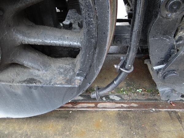
Sand for Traction
Steam engines used high-grade silica sand for traction on the rails. Sand was stored in a dome on top of the engine and, as the train traveled the tracks, the sand would be sprinkled down pipes to land on the tracks in front of the wheels. This would aid the wheels in gripping the tracks, especially when the rails were wet.
Steam engines used high-grade silica sand for traction on the rails. Sand was stored in a dome on top of the engine and, as the train traveled the tracks, the sand would be sprinkled down pipes to land on the tracks in front of the wheels. This would aid the wheels in gripping the tracks, especially when the rails were wet.

Fall Colors in Upstate New York
Fall colors can be seen in Upstate New York along the banks of the Tioughnioga River near Whitney Point.
Fall colors can be seen in Upstate New York along the banks of the Tioughnioga River near Whitney Point.

Glines Canyon East Abutment
Visitors at Glines Canyon East Abutment in Olympic National Park, the location of the Elwha River Restoration project. Image available at Olympic National Park flickr site.
Visitors at Glines Canyon East Abutment in Olympic National Park, the location of the Elwha River Restoration project. Image available at Olympic National Park flickr site.

Black-footed Ferret Release
An endangered black-footed ferret is released on private land in Arizona as part of a collaborative species recovery effort.
An endangered black-footed ferret is released on private land in Arizona as part of a collaborative species recovery effort.

Flooding in Nebraska
Jet ski in fotsam at Salt Creek at Greenwood, NE.
Jet ski in fotsam at Salt Creek at Greenwood, NE.

Adult Female Pallid Sturgeon
Female pallid sturgeon captured in the Missouri River near Boonville, MO.
Female pallid sturgeon captured in the Missouri River near Boonville, MO.

Whoopers Released
A Whooping crane chick is released into a temporary pen to acclimate before being released into the wild. Four of the endangered chicks, hatched and raised by their parents at the U.S. Geological Survey’s Patuxent Wildlife Research Center in Laurel, Maryland, were released on Necedah National Wildlife Refuge in Wisconsin.
A Whooping crane chick is released into a temporary pen to acclimate before being released into the wild. Four of the endangered chicks, hatched and raised by their parents at the U.S. Geological Survey’s Patuxent Wildlife Research Center in Laurel, Maryland, were released on Necedah National Wildlife Refuge in Wisconsin.
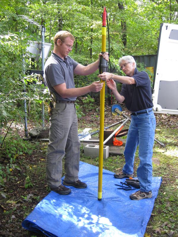
USGS scientists prepare to collect a Nuclear Magnetic Resonance log
USGS scientists prepare to collect a Nuclear Magnetic Resonance logUSGS scientists J. Alton Anderson and Carole D. Johnson prepare to collect a Nuclear Magnetic Resonance (NMR) log at a well.
USGS scientists prepare to collect a Nuclear Magnetic Resonance log
USGS scientists prepare to collect a Nuclear Magnetic Resonance logUSGS scientists J. Alton Anderson and Carole D. Johnson prepare to collect a Nuclear Magnetic Resonance (NMR) log at a well.

Scientist collecting data after the Oso landslide
USGS scientist, Mark Reid, in front of the exact place where the main body of the landslide, composed of glacial lacustrine clay, overrode the liquified alluvium of the river valley.
USGS scientist, Mark Reid, in front of the exact place where the main body of the landslide, composed of glacial lacustrine clay, overrode the liquified alluvium of the river valley.

Scientists Explore Hawaii's Coast
Coral growth offshore of the Hawaiian Island of Kahoʻolawe has been significantly impacted by the island's deforestation and resulting erosion and sediment run-off into the nearshore environment. This image is of a coral reef in deeper waters offshore of Kahoʻolawe.
Coral growth offshore of the Hawaiian Island of Kahoʻolawe has been significantly impacted by the island's deforestation and resulting erosion and sediment run-off into the nearshore environment. This image is of a coral reef in deeper waters offshore of Kahoʻolawe.