How hot do wildfires get?
- 570 F degrees - TEMPERATURE AT WHICH WOOD WILL BURST INTO FLAMES
- 2,200 F degrees - TEMPERATURE WILDFIRES COULD REACH IN EXTREME CONDITIONS

Official websites use .gov
A .gov website belongs to an official government organization in the United States.
Secure .gov websites use HTTPS
A lock () or https:// means you’ve safely connected to the .gov website. Share sensitive information only on official, secure websites.
Images

How hot do wildfires get?
How hot do wildfires get?

USGS fire science informs land, water, and emergency management decisions. Each year tens of thousands of wildfires cause billions of dollars of damage.
USGS fire science informs land, water, and emergency management decisions. Each year tens of thousands of wildfires cause billions of dollars of damage.

MEET A FIRE SCIENTIST: Rachel A Loehman, Ph.D.
I study the complexities between people and nature, particularly the impacts of wildfires on landscapes, habitats, and natural resources
MEET A FIRE SCIENTIST: Rachel A Loehman, Ph.D.
I study the complexities between people and nature, particularly the impacts of wildfires on landscapes, habitats, and natural resources

Fast-moving, highly destructive debris flows triggered by intense rainfall are one of the most dangerous post-fire hazards. The risk of floods and debris flows after fires increases due to vegetation loss and soil exposure. Cases of sudden and deadly debris flow are well documented along the western United States, particularly in Southern California.
Fast-moving, highly destructive debris flows triggered by intense rainfall are one of the most dangerous post-fire hazards. The risk of floods and debris flows after fires increases due to vegetation loss and soil exposure. Cases of sudden and deadly debris flow are well documented along the western United States, particularly in Southern California.

USGS Water and Fire Technicians team members, Jorge Gonzalez and Efren Alvarado, made repairs to the Buck Mountain precipitation gage during the Blue 2 Fire near Alto, New Mexico on June 7, 2024. This station, along with similar gages, provides critical real-time rainfall data to the National Weather Service and local emergency managers.
USGS Water and Fire Technicians team members, Jorge Gonzalez and Efren Alvarado, made repairs to the Buck Mountain precipitation gage during the Blue 2 Fire near Alto, New Mexico on June 7, 2024. This station, along with similar gages, provides critical real-time rainfall data to the National Weather Service and local emergency managers.

A new eruption began along Kīlauea's Southwest Rift Zone on June 3, 2024, and this map depicts activity on the eruption's first day. New lava flows are shown in red, only covering about 88 acres (36 hectares) of ground within relatively short distances of the eruptive fissures.
A new eruption began along Kīlauea's Southwest Rift Zone on June 3, 2024, and this map depicts activity on the eruption's first day. New lava flows are shown in red, only covering about 88 acres (36 hectares) of ground within relatively short distances of the eruptive fissures.

The U.S. Geological Survey and German Aerospace Center (Deutsches Zentrum für Luft-und Raumfahrt or DLR sign statement for plans to continue partnership with the upcoming Landsat Next satellite mission.
The U.S. Geological Survey and German Aerospace Center (Deutsches Zentrum für Luft-und Raumfahrt or DLR sign statement for plans to continue partnership with the upcoming Landsat Next satellite mission.
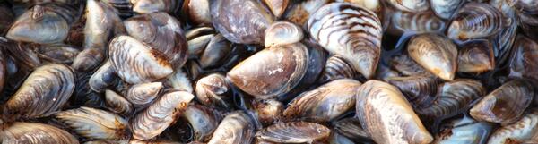
Zebra mussels, an invasive species that threatens U.S. waters. Photograph Credit: Dave Britton, U.S. Fish and Wildlife Service.
Zebra mussels, an invasive species that threatens U.S. waters. Photograph Credit: Dave Britton, U.S. Fish and Wildlife Service.

Image from the inaugural U.S.-Germany Space Dialogue Space Dialogue in Berlin on June 4, 2024.
Image from the inaugural U.S.-Germany Space Dialogue Space Dialogue in Berlin on June 4, 2024.

USGS and German Aerospace Center sign statement of intent for upcoming Landsat Next mission.
(Left to Right): Head of the DLR Space Division Dr. Anke Pagels-Kerp and USGS Deputy Director-Operations Cindy Lodge.
USGS and German Aerospace Center sign statement of intent for upcoming Landsat Next mission.
(Left to Right): Head of the DLR Space Division Dr. Anke Pagels-Kerp and USGS Deputy Director-Operations Cindy Lodge.

USGS Deputy Director-Operations Cindy Lodge shown here with DLR’s German Remote Sensing Data Center (DFD) Director professor Stefan Dech at DLR’s Earth Observation Center in Oberpfaffenhofen finalizing the signatures on the statement of intent for the upcoming Landsat Next mission.
USGS Deputy Director-Operations Cindy Lodge shown here with DLR’s German Remote Sensing Data Center (DFD) Director professor Stefan Dech at DLR’s Earth Observation Center in Oberpfaffenhofen finalizing the signatures on the statement of intent for the upcoming Landsat Next mission.
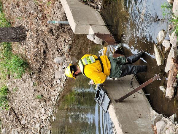
A member of the USGS Water and Fire Technicians Team repairs a streamgage during the Blue 2 Fire near Alto, New Mexico.
A member of the USGS Water and Fire Technicians Team repairs a streamgage during the Blue 2 Fire near Alto, New Mexico.

The USGS Water and Fire Technicians Team prepares to evaluate precipitation and streamflow gauges during the Blue 2 Fire near Alto, New Mexico.
The USGS Water and Fire Technicians Team prepares to evaluate precipitation and streamflow gauges during the Blue 2 Fire near Alto, New Mexico.

A buoy marking the location of monitoring equipment in Pool 13 of the Upper Mississippi River in 2024. The equipment is placed below the water surface to monitor waves and water clarity in the spring and summer.
A buoy marking the location of monitoring equipment in Pool 13 of the Upper Mississippi River in 2024. The equipment is placed below the water surface to monitor waves and water clarity in the spring and summer.

How Streamgages are Used in Postfire Flood Forecasting
Stream data is recorded in real time and posted online.
Stream data include water level, velocity, and turbidity.
During storms, rainfall data is compared to the stream data.
The National Weather Service uses the data to issue flood warnings.
How Streamgages are Used in Postfire Flood Forecasting
Stream data is recorded in real time and posted online.
Stream data include water level, velocity, and turbidity.
During storms, rainfall data is compared to the stream data.
The National Weather Service uses the data to issue flood warnings.

Paul Laustsen at the 2024 OCAP Academy in Reston, VA. Photo by Megan Evans.
Paul Laustsen at the 2024 OCAP Academy in Reston, VA. Photo by Megan Evans.
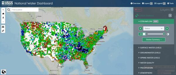
Caption: This image shows a screenshot of the online USGS National Water Dashboard.
Caption: This image shows a screenshot of the online USGS National Water Dashboard.
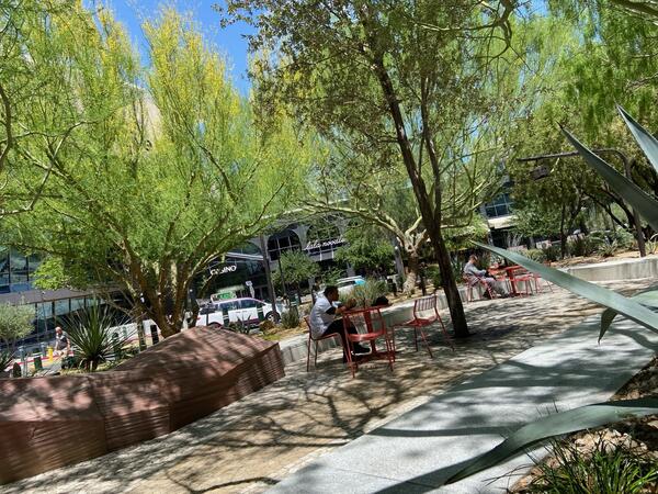
Park off Las Vegas strip where people are surrounded by trees. People in image are seated at red tables and one person is walking in distance outside of hotel.
Park off Las Vegas strip where people are surrounded by trees. People in image are seated at red tables and one person is walking in distance outside of hotel.
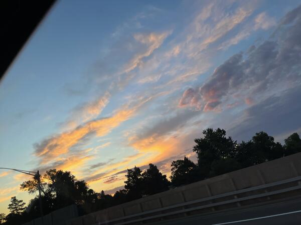
Image of trees taken from passenger window along 170 outside of Denver before sunset. Trees appear almost black and sky is blue with pink, orange and purple clouds.
Image of trees taken from passenger window along 170 outside of Denver before sunset. Trees appear almost black and sky is blue with pink, orange and purple clouds.

A view of the study area of Pool 13 of the Upper Mississippi River on a calm day from Eagle Point Park in Clinton, IA.
A view of the study area of Pool 13 of the Upper Mississippi River on a calm day from Eagle Point Park in Clinton, IA.

USGS and USFWS logos with title "An Orchestra of Conservation for the Melodies of Hakalau Forest" featured on an image of a red apapane bird against a blue sky background
USGS and USFWS logos with title "An Orchestra of Conservation for the Melodies of Hakalau Forest" featured on an image of a red apapane bird against a blue sky background