Volcano Evacuation Route sign along a roadway in WA State.
Volcano Evacuation Route sign along a roadway in WA State.Volcano Evacuation Route sign along a roadway in Washington State.

Official websites use .gov
A .gov website belongs to an official government organization in the United States.
Secure .gov websites use HTTPS
A lock () or https:// means you’ve safely connected to the .gov website. Share sensitive information only on official, secure websites.
Images

Volcano Evacuation Route sign along a roadway in Washington State.
Volcano Evacuation Route sign along a roadway in Washington State.

A level crew running a line from Mojave, California to Keeler, California via the state road, preparing the way for topographers to follow. R.A. Farmer, just to the left of the long-barreled Engineers WYE level instrument, was the levelman and Chief of Party.
A level crew running a line from Mojave, California to Keeler, California via the state road, preparing the way for topographers to follow. R.A. Farmer, just to the left of the long-barreled Engineers WYE level instrument, was the levelman and Chief of Party.

Image scan of a historical bird migration card (1904).
Image scan of a historical bird migration card (1904).

Topographic mapping crew poses in camp in the Cascade Mountains of Washington.
Topographic mapping crew poses in camp in the Cascade Mountains of Washington.
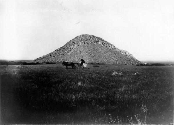
Ground repeat photography location 233 looking west at Huérfano Butte, at 1,159-meter elevation. In 1902, photographer David Griffiths’ horse-drawn buggy was clearly visible in the open grassland, and scattered desert hackberry plants were behind and on either side of the buggy. (David Griffiths).
Ground repeat photography location 233 looking west at Huérfano Butte, at 1,159-meter elevation. In 1902, photographer David Griffiths’ horse-drawn buggy was clearly visible in the open grassland, and scattered desert hackberry plants were behind and on either side of the buggy. (David Griffiths).

USGS laboratory in Washington DC where water samples 1883-87 from Yellowstone National Park were analyzed. Photograph, USGS Historical Photography Library.
USGS laboratory in Washington DC where water samples 1883-87 from Yellowstone National Park were analyzed. Photograph, USGS Historical Photography Library.

Cliff Palace, Mesa Verde National Park, Colorado - 1891
Cliff Palace, Mesa Verde National Park, Colorado - 1891

Hydrographer taking a cableway streamflow measurement at the first USGS streamgage at Embudo, New Mexico, established in 1889.
Hydrographer taking a cableway streamflow measurement at the first USGS streamgage at Embudo, New Mexico, established in 1889.

USGS prersonnel at the Embudo Station, New Mexico. Embudo was selected as the site of the first USGS streamgaging station in 1889 because of the need for systematic water resource assessments of western states as it not only offered a favorable climate and easy rail access, but qualified for congressional funding tapped specifically for the “arid West.”
USGS prersonnel at the Embudo Station, New Mexico. Embudo was selected as the site of the first USGS streamgaging station in 1889 because of the need for systematic water resource assessments of western states as it not only offered a favorable climate and easy rail access, but qualified for congressional funding tapped specifically for the “arid West.”

Embudo Student Hydrographers

Old Faithful Geyser in Upper Geyser Basin. 1878(?). Yellowstone National Park, Wyoming. U.S. Geological and Geographical Survey of the Territories (Hayden Survey).
Old Faithful Geyser in Upper Geyser Basin. 1878(?). Yellowstone National Park, Wyoming. U.S. Geological and Geographical Survey of the Territories (Hayden Survey).

Portrait of Ferdinand V. Hayden, about the time of his directorship of the Geological Survey of the Territories. c. 1870. The Hayden Survey was a predecessor to the USGS.
Portrait of Ferdinand V. Hayden, about the time of his directorship of the Geological Survey of the Territories. c. 1870. The Hayden Survey was a predecessor to the USGS.

U.S. Geological and Geographical Survey of the Territories (Hayden Survey). Group of all the members of the Survey, made while in camp at Red Buttes at the junction of the North Platte and Sweetwater Rivers. Natrona County, Wyoming, 1870. Standing left to right: John "Potato John" Raymond and "Val," cooks; Sanford R. Gifford, landscape painter; Henry W.
U.S. Geological and Geographical Survey of the Territories (Hayden Survey). Group of all the members of the Survey, made while in camp at Red Buttes at the junction of the North Platte and Sweetwater Rivers. Natrona County, Wyoming, 1870. Standing left to right: John "Potato John" Raymond and "Val," cooks; Sanford R. Gifford, landscape painter; Henry W.

Strong shaking during the 1868 Hayward Fault earthquake caused the second story of the Alameda County Courthouse in San Leandro to collapse (photo courtesy of the Bancroft Library, University of California). The inset photo shows the courthouse before the quake
Strong shaking during the 1868 Hayward Fault earthquake caused the second story of the Alameda County Courthouse in San Leandro to collapse (photo courtesy of the Bancroft Library, University of California). The inset photo shows the courthouse before the quake

A curious smallmouth bass following behind scuba divers in Sparkling Lake, Vilas County, Wis.
A curious smallmouth bass following behind scuba divers in Sparkling Lake, Vilas County, Wis.
Sign in desk, taken at the first Federal Unmanned Aircraft Systems Workshop.
Sign in desk, taken at the first Federal Unmanned Aircraft Systems Workshop.

Red and Bonita Mine located approximately .4 miles from the Gold King Mine.
Red and Bonita Mine located approximately .4 miles from the Gold King Mine.

Red and Bonita Mine located approximately .4 miles from the Gold King Mine.
Red and Bonita Mine located approximately .4 miles from the Gold King Mine.

Red and Bonita Mine located approximately .4 miles from the Gold King Mine.
Red and Bonita Mine located approximately .4 miles from the Gold King Mine.

USGS staff checking the streamgage equipment on the San Saba River in Texas.
USGS staff checking the streamgage equipment on the San Saba River in Texas.

EON Geosciences airplane under contract to the USGS for low-level flights in Cedar Rapids/Waterloo, Iowa, area.
EON Geosciences airplane under contract to the USGS for low-level flights in Cedar Rapids/Waterloo, Iowa, area.