
Adult, immature, and nymph stage box elder bugs gather on the leaves of a hosta plant growing at the base of a silver maple tree. Adults have fully formed, mainly black wings.
Images
Images
Filter Total Items: 9452

Boxelder Bugs Gather on the Leaves of Hosta 4
Adult, immature, and nymph stage box elder bugs gather on the leaves of a hosta plant growing at the base of a silver maple tree. Adults have fully formed, mainly black wings.

Honey Bees Make Life Sweet
Honey bees live and work in highly collaborative, social colonies with a sole reproducing queen, and they make honey by storing nectar from flowering plants in their hives for use during food scarcities.
Honey bees live and work in highly collaborative, social colonies with a sole reproducing queen, and they make honey by storing nectar from flowering plants in their hives for use during food scarcities.

USGS Honey Bee Research
The USGS researches land use and honey bee health in the northern Great Plains. This research will be useful in equipping land managers and policy makers with the best-available science to improve forage and habitat for pollinators in a part of the country that is undergoing rapid land-use change.
The USGS researches land use and honey bee health in the northern Great Plains. This research will be useful in equipping land managers and policy makers with the best-available science to improve forage and habitat for pollinators in a part of the country that is undergoing rapid land-use change.

Shake Table at Dusk
Shake Table at dusk, lit by flourescent lights installed under the table in addition to a high-powered, hand-held flashlight.
Shake Table at dusk, lit by flourescent lights installed under the table in addition to a high-powered, hand-held flashlight.

Shake Table at Night
An 8.5-minute exposure taken on a moonless night with a blue-gel'd flashlight to fill in the top of the shake table.
An 8.5-minute exposure taken on a moonless night with a blue-gel'd flashlight to fill in the top of the shake table.

Shake Table at Night
A 30-second exposure with the fluorescent lights underneath the table switched on for a split second.
A 30-second exposure with the fluorescent lights underneath the table switched on for a split second.

Control Center for the Shake Table
D.V. Rogers in the "Bunker," the control center for the project. Real-time earthquakes are received via satellite internet.
D.V. Rogers in the "Bunker," the control center for the project. Real-time earthquakes are received via satellite internet.

Eggs in Sparrow Nest
Clay-colored sparrow nest.

Bird Migration Cards
Volunteers Derek Smith (white shirt) and Reuben Anderson sort through migration cards in the Bird Phenology Program Office.
Volunteers Derek Smith (white shirt) and Reuben Anderson sort through migration cards in the Bird Phenology Program Office.

USGS Scientist at Work
Brent Knights and Jon Vallazza conduct a river productivity study aboard the E.D. Cope, Upper Mississippi River System.
Brent Knights and Jon Vallazza conduct a river productivity study aboard the E.D. Cope, Upper Mississippi River System.

Road Repair in Indian Country
Workers repairing a road.

School Construction in Indian Country
A new school being constructed.

Molten Rock Streaming into Water
The molten rock mixture cools upon contact with lukewarm water, instantly creating glassy agglutinate.
__________
The molten rock mixture cools upon contact with lukewarm water, instantly creating glassy agglutinate.
__________

Separating Water from Agglutinate
When the water is separated from the cooled molten rock, agglutinate is collected.
__________
The USGS has created man-made moon dirt, or regolith, to help NASA prepare for upcoming moon explorations. Four tons of the simulant is expected to be made by this summer of 2009 and turned over to the scientific community involved in lunar exploration.

Zybek Melter in Action
Plasma torches at Zybek Advanced Products blaze at over 37,000 degrees Fahrenheit, melting the rock mixture.
Plasma torches at Zybek Advanced Products blaze at over 37,000 degrees Fahrenheit, melting the rock mixture.

Aerial View of the Audubon NWR
This photo shows an aerial view of the existing facilities at Audubon National Wildlife Refuge. Related to the R6BB Construct Headquarters Visitor Building Audubon NWR project.
This photo shows an aerial view of the existing facilities at Audubon National Wildlife Refuge. Related to the R6BB Construct Headquarters Visitor Building Audubon NWR project.
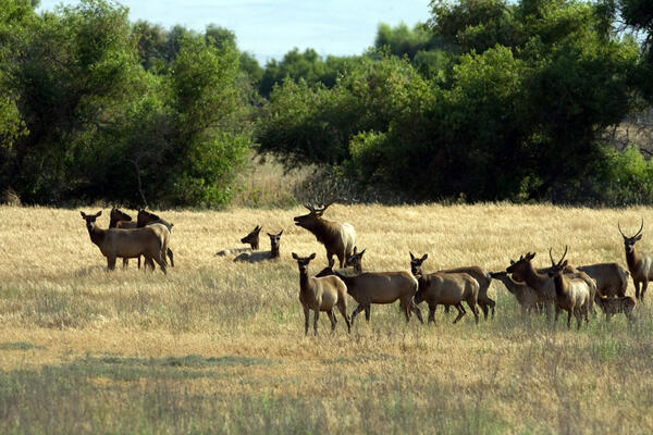
Tule Elk at San Luis National Wildlife Refuge
Tule elk are shown here in their natural habitat at San Luis National Wildlife Refuge; Recovery Act funding will enable the refuge to build a Visitor Center to better serve the public. Related to the R8AF Construct Headquarters Visitor Building San Luis NWR project.
Tule elk are shown here in their natural habitat at San Luis National Wildlife Refuge; Recovery Act funding will enable the refuge to build a Visitor Center to better serve the public. Related to the R8AF Construct Headquarters Visitor Building San Luis NWR project.
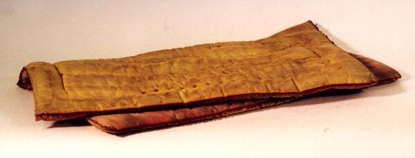
Saddle Blanket
This is one of many saddle blankets from Dr. J.D. Love. The blanket has some felt decoration along the edges and is in particularily good condition. Saddle Blankets were used under saddles or pack saddles to provide comfort for animals used to carry equipment.
Object ID: USGS-000011
This is one of many saddle blankets from Dr. J.D. Love. The blanket has some felt decoration along the edges and is in particularily good condition. Saddle Blankets were used under saddles or pack saddles to provide comfort for animals used to carry equipment.
Object ID: USGS-000011
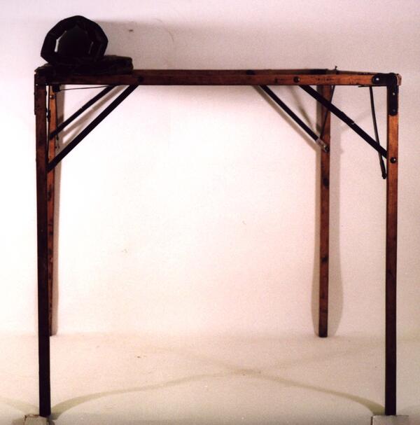
Field Table
This is a rolltop table used by Arnold Hague. The table top is made of oilcloth and rolls up. The table, legs and frame can be collapsed for easy travel and the package can then be carried on a wooden pack saddle.
Object ID: USGS-000023
This is a rolltop table used by Arnold Hague. The table top is made of oilcloth and rolls up. The table, legs and frame can be collapsed for easy travel and the package can then be carried on a wooden pack saddle.
Object ID: USGS-000023
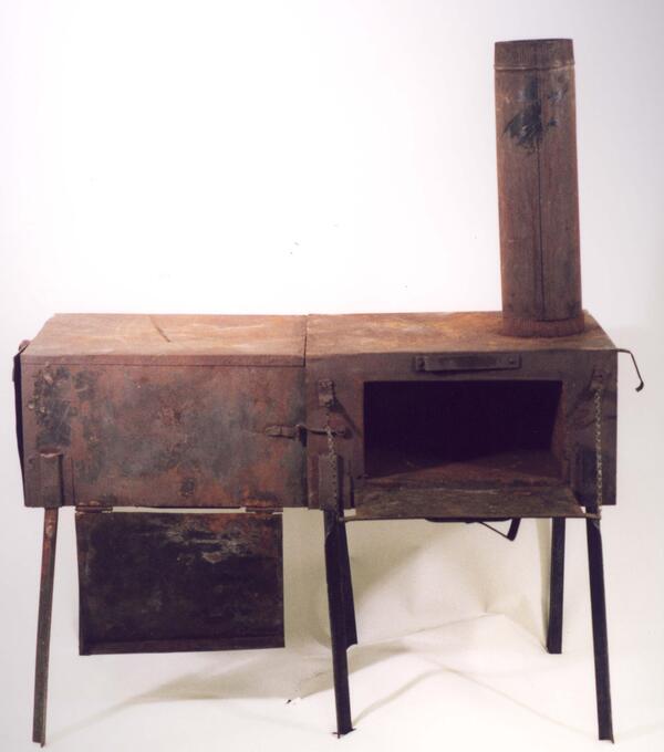
Rema Stove
This is a "Rema Stove." It was invented by Bill Rema and the design was never patented. This is likely the only remaining stove of its kind. Dr. J. D. Love added a few elements, but it is essentially built to the original specifications. This stove was used extensively by USGS field scientists.
Object ID: USGS-000034
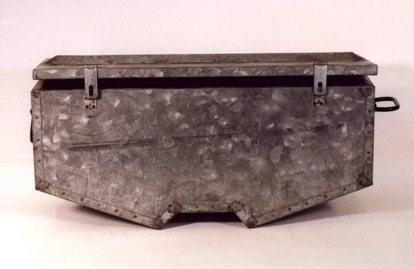
Aluminum Pannier
This aluminum pannier was made for the storage of meat, vegetables and other food products. The pannier could be buried in the ground or placed in water in order to keep the contents cool. It was designed by Dr. J. D. Love and made for him in 1945.
This aluminum pannier was made for the storage of meat, vegetables and other food products. The pannier could be buried in the ground or placed in water in order to keep the contents cool. It was designed by Dr. J. D. Love and made for him in 1945.