
This belt is one of many personal items included in the geological collection. It may have been used with clips to hold equipment for easy access in the field.
Object ID: USGS-000093
Images
Images
Filter Total Items: 9452
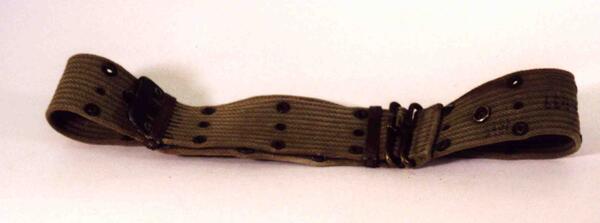
Tool Belt
This belt is one of many personal items included in the geological collection. It may have been used with clips to hold equipment for easy access in the field.
Object ID: USGS-000093
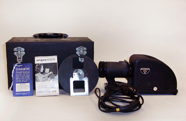
Argus Film Projector
Manufactured by Argus Inc, Ann Arbor, Michigan. This projector was used for 35mm slides.
Object ID: USGS-000194
Manufactured by Argus Inc, Ann Arbor, Michigan. This projector was used for 35mm slides.
Object ID: USGS-000194
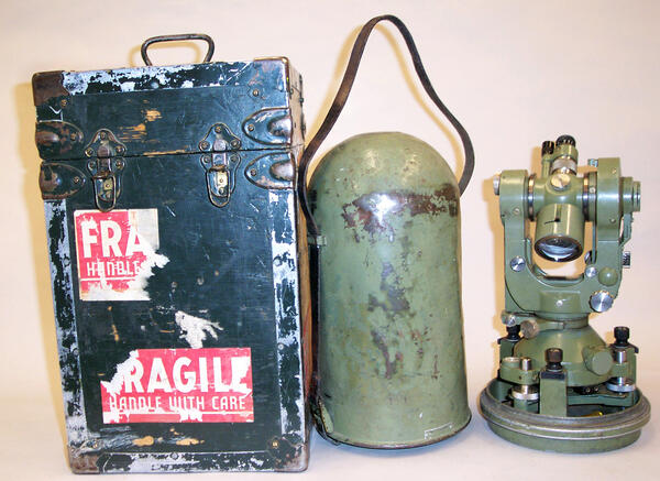
T21 Theodolite
Manufactured by WILD Heerbrugg, Switzerland. This instrument was made in the late 1950s- early 1960s and was in service until the late 1970s. It includes its original air-tight and water-tight steel case, as well as its shipping case.
Object ID: USGS-000198
Manufactured by WILD Heerbrugg, Switzerland. This instrument was made in the late 1950s- early 1960s and was in service until the late 1970s. It includes its original air-tight and water-tight steel case, as well as its shipping case.
Object ID: USGS-000198

35mm Coupled Rangefinder Camera
Equipped with a Summaron Lens, 1950s. Manufactured in Leitz, Germany.
Object ID: USGS-000277
Equipped with a Summaron Lens, 1950s. Manufactured in Leitz, Germany.
Object ID: USGS-000277

Kodak Folding Pocket Camera
With original case.
Object ID: USGS-000287
With original case.
Object ID: USGS-000287
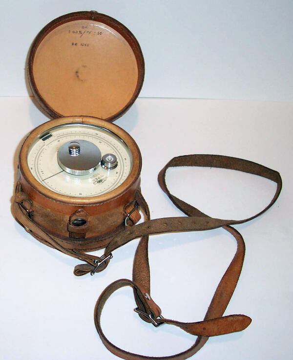
Surveying Altimeter
This type of altimeter is a precision aneroid barometer that translates barometric (air) pressure into altitude. Temperature compensation calculations, as well as calculations to account for diurnal barometric change need to be recorded during use.
This type of altimeter is a precision aneroid barometer that translates barometric (air) pressure into altitude. Temperature compensation calculations, as well as calculations to account for diurnal barometric change need to be recorded during use.

Water Testing PH Analysis Kit
Manufactured by Lamotte Chemical Products Company, Chestertown, Maryland sometime after 1930.
Object ID: USGS-000249
Manufactured by Lamotte Chemical Products Company, Chestertown, Maryland sometime after 1930.
Object ID: USGS-000249

Black-Tailed Prairie Dog
Black-tailed prairie dogs are quite susceptible to sylvatic plague, but a new plague vaccine put in their food shows significant promise in the laboratory. The prairie dogs transmit the disease to endangered black-footed ferrets, who eat the prairie dogs and are also quite susceptible to the disease.
Black-tailed prairie dogs are quite susceptible to sylvatic plague, but a new plague vaccine put in their food shows significant promise in the laboratory. The prairie dogs transmit the disease to endangered black-footed ferrets, who eat the prairie dogs and are also quite susceptible to the disease.
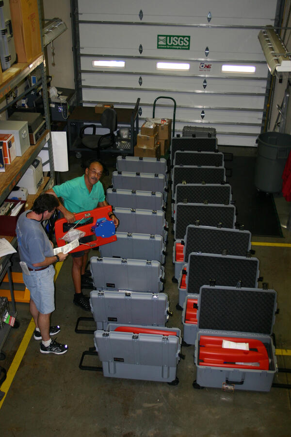
Acoustic Doppler Current Profilers
USGS Hydrologic Instrumentation Facilities employee Jerry Gardner and contract employee Rodger Cook, prepare recently acquired Acoustic Doppler Profilers for distribution to USGS Water Science Centers.
USGS Hydrologic Instrumentation Facilities employee Jerry Gardner and contract employee Rodger Cook, prepare recently acquired Acoustic Doppler Profilers for distribution to USGS Water Science Centers.
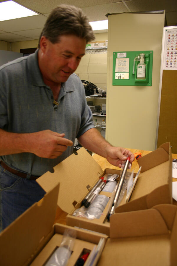
Pressure Transducer Unit
USGS Contract employee Kevin Hadley examines a pressure tranducer unit prior to subjecting it to quality assurance testing.
USGS Contract employee Kevin Hadley examines a pressure tranducer unit prior to subjecting it to quality assurance testing.

1928 South Cascade Glacier
1928 black-and-white oblique-angle aerial photo of South Cascade Glacier, northwestern Washington State, looking approximately southeast.
1928 black-and-white oblique-angle aerial photo of South Cascade Glacier, northwestern Washington State, looking approximately southeast.
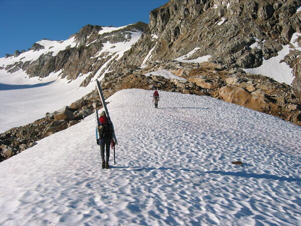
USGS scientist
USGS scientists head out for a day's work on South Cascade Glacier, northwestern Washington State.
USGS scientists head out for a day's work on South Cascade Glacier, northwestern Washington State.
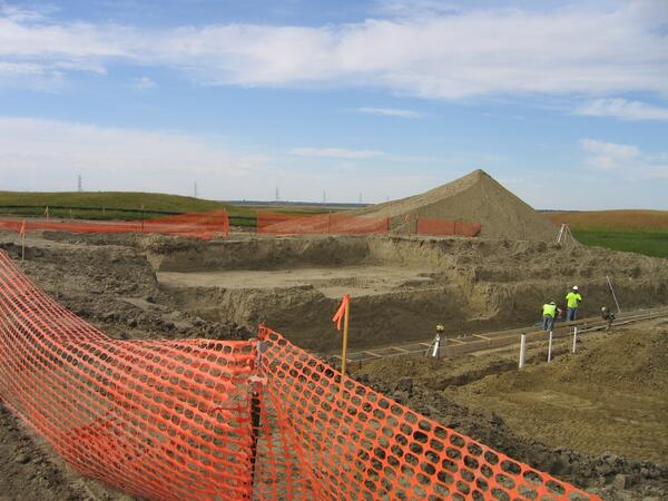
Excavation for Conference Room
This photo shows workers completing the excavation at the site for the conference room in the new Audubon NWR Headquarters. This project, funded by the Recovery Act, will allow the Refuge to replace the current headquarters and visitor facility, which is approximately 52 years old and has had four additions added to it over the years.
This photo shows workers completing the excavation at the site for the conference room in the new Audubon NWR Headquarters. This project, funded by the Recovery Act, will allow the Refuge to replace the current headquarters and visitor facility, which is approximately 52 years old and has had four additions added to it over the years.

Bats and Wind Energy
USGS biologist Paul Cryan examines the carcass of a hoary bat (Lasiurus cinereus) found beneath a wind turbine. By examining the casualties, biologists hope to learn more about why migratory bats are so susceptible to wind turbines.
USGS biologist Paul Cryan examines the carcass of a hoary bat (Lasiurus cinereus) found beneath a wind turbine. By examining the casualties, biologists hope to learn more about why migratory bats are so susceptible to wind turbines.

Wind Turbine
The species of bats that are most susceptible to wind turbines all roost in trees throughout the year, leading some scientists to speculate that they may be visually mistaking wind turbines for trees in which to roost.
The species of bats that are most susceptible to wind turbines all roost in trees throughout the year, leading some scientists to speculate that they may be visually mistaking wind turbines for trees in which to roost.

Beni Anaconda (Eunectes beniensis)
Beni or Bolivian Anaconda (Eunectes beniensis). Photo by Lutz Dirksen, www.anakondas.de. Used with permission.
Beni or Bolivian Anaconda (Eunectes beniensis). Photo by Lutz Dirksen, www.anakondas.de. Used with permission.

Southern African Python
Southern African Python (Python natalensis). The snake pictured is a representative of a species discussed in the USGS snake risk assessment. This snake was photographed in its native range.
Southern African Python (Python natalensis). The snake pictured is a representative of a species discussed in the USGS snake risk assessment. This snake was photographed in its native range.

Bat with Radio Transmitter
USGS biologist Paul Cryan releases a bat carrying a miniature radio transmitter. Researchers are increasingly turning to high-tech methods to try to learn more about the mysterious lives of bats.
USGS biologist Paul Cryan releases a bat carrying a miniature radio transmitter. Researchers are increasingly turning to high-tech methods to try to learn more about the mysterious lives of bats.
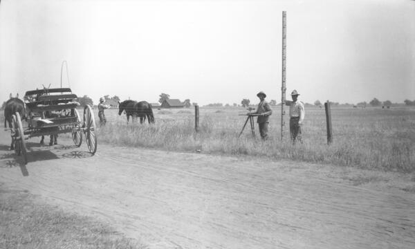
USGS Topographers at Work
USGS topographers pose with their leveling instrument and leveling rod.
USGS topographers pose with their leveling instrument and leveling rod.

Dave Mech Following Wolves
Late in the evening, two wolves make use of the trail that leads to the head of the fiord. Studying wolves in the High Arctic allows scientists to follow the wolves during their travels, assuming the scientists can keep up. All-terrain vehicles are needed, and the 24-hour daylight at this time of year is critical.
Late in the evening, two wolves make use of the trail that leads to the head of the fiord. Studying wolves in the High Arctic allows scientists to follow the wolves during their travels, assuming the scientists can keep up. All-terrain vehicles are needed, and the 24-hour daylight at this time of year is critical.

Brutus the North Pole Wolf
USGS biologist Dave Mech has spent more than 20 summers studying Arctic wolves on Ellesmere Island, where they are unafraid of humans and can be observed at close range.
USGS biologist Dave Mech has spent more than 20 summers studying Arctic wolves on Ellesmere Island, where they are unafraid of humans and can be observed at close range.