
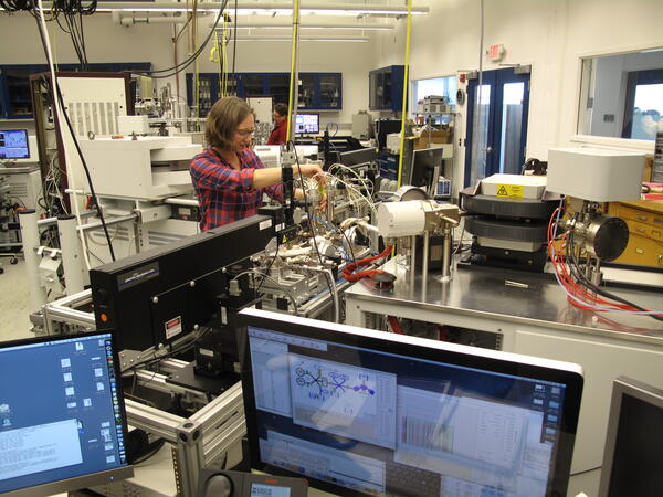
This project supports the USGS argon geochronology laboratory in Denver. The USGS 40Ar/39Ar geochronology laboratory is a state-of-the-art research facility for determining absolute ages of minerals and rocks. The 40Ar/39Ar laboratory contributes critical geochronology to individual USGS research projects and to partners in academia and other Federal agencies. This laboratory develops methodology for small and difficult sample analysis often at the limits of existing mass spectrometer technology.
Science Issue and Relevance
The 40Ar/39Ar Method: 40Ar/39Ar geochronology is an experimentally robust and versatile method for constraining the age and thermal history of rocks. Such information is extremely valuable for understanding a variety of geological processes including the formation of ore deposits, mountain building and history of volcanic events, paleo-seismic events, and paleo-climate. The 40Ar/39Ar isotopic dating method has evolved into the most commonly applied geochronological method, and can be applied to many geological problems that require precise and accurate time and temperature control.
Methodology to Address Issue
This project provides partial support for the USGS argon geochronology laboratory in Denver. The USGS 40Ar/39Ar geochronology laboratory is a state-of-the-art research facility for determining absolute ages of minerals and rocks. The 40Ar/39Ar laboratory contributes critical geochronology to individual USGS research projects and to partners in academia and other Federal agencies. This facility houses necessary equipment for sample preparation and analysis, including high-sensitivity noble gas mass spectrometers and ultraviolet (UV) and infrared (IR) lasers. The versatility of the 40Ar/39Ar method permits determining the timing of processes and events such as igneous intrusions and extrusions, ore mineralization and hydrothermal fluid circulation, metamorphic cooling and exhumation, mineral formation and recrystallization, and shallow crustal faulting. Scientists are dependent on the geochronologist for data and interpretations to determine these parameters. This laboratory develops methodology for small and difficult sample analysis often at the limits of existing mass spectrometer technology.
Below are other science projects associated with this project.

Porphyry Copper Systems of the Boulder batholith, Montana

USGS Geochron: A database of USGS geochronological and thermochronological data

Evaluation of Critical Elements in Carbonatites

Geologic Framework of the Intermountain West

Serving the U.S. Geological Survey’s geochronological data
This project supports the USGS argon geochronology laboratory in Denver. The USGS 40Ar/39Ar geochronology laboratory is a state-of-the-art research facility for determining absolute ages of minerals and rocks. The 40Ar/39Ar laboratory contributes critical geochronology to individual USGS research projects and to partners in academia and other Federal agencies. This laboratory develops methodology for small and difficult sample analysis often at the limits of existing mass spectrometer technology.
Science Issue and Relevance
The 40Ar/39Ar Method: 40Ar/39Ar geochronology is an experimentally robust and versatile method for constraining the age and thermal history of rocks. Such information is extremely valuable for understanding a variety of geological processes including the formation of ore deposits, mountain building and history of volcanic events, paleo-seismic events, and paleo-climate. The 40Ar/39Ar isotopic dating method has evolved into the most commonly applied geochronological method, and can be applied to many geological problems that require precise and accurate time and temperature control.
Methodology to Address Issue
This project provides partial support for the USGS argon geochronology laboratory in Denver. The USGS 40Ar/39Ar geochronology laboratory is a state-of-the-art research facility for determining absolute ages of minerals and rocks. The 40Ar/39Ar laboratory contributes critical geochronology to individual USGS research projects and to partners in academia and other Federal agencies. This facility houses necessary equipment for sample preparation and analysis, including high-sensitivity noble gas mass spectrometers and ultraviolet (UV) and infrared (IR) lasers. The versatility of the 40Ar/39Ar method permits determining the timing of processes and events such as igneous intrusions and extrusions, ore mineralization and hydrothermal fluid circulation, metamorphic cooling and exhumation, mineral formation and recrystallization, and shallow crustal faulting. Scientists are dependent on the geochronologist for data and interpretations to determine these parameters. This laboratory develops methodology for small and difficult sample analysis often at the limits of existing mass spectrometer technology.
Below are other science projects associated with this project.
Porphyry Copper Systems of the Boulder batholith, Montana
USGS Geochron: A database of USGS geochronological and thermochronological data
Evaluation of Critical Elements in Carbonatites
Geologic Framework of the Intermountain West