Cover of California's Fourth Climate Change Assessment Report
Cover of California's Fourth Climate Change Assessment ReportCover of the 2018 publication, "California’s Fourth Climate Change Assessment: Statewide Summary Report."

Official websites use .gov
A .gov website belongs to an official government organization in the United States.
Secure .gov websites use HTTPS
A lock () or https:// means you’ve safely connected to the .gov website. Share sensitive information only on official, secure websites.
Coastal and Marine Hazards and Resources Program images.

Cover of the 2018 publication, "California’s Fourth Climate Change Assessment: Statewide Summary Report."
Cover of the 2018 publication, "California’s Fourth Climate Change Assessment: Statewide Summary Report."

Unalakleet village on the low-lying barrier spit at the inlet of the Unalakleet River and Norton Sound, Alaska.
Unalakleet village on the low-lying barrier spit at the inlet of the Unalakleet River and Norton Sound, Alaska.
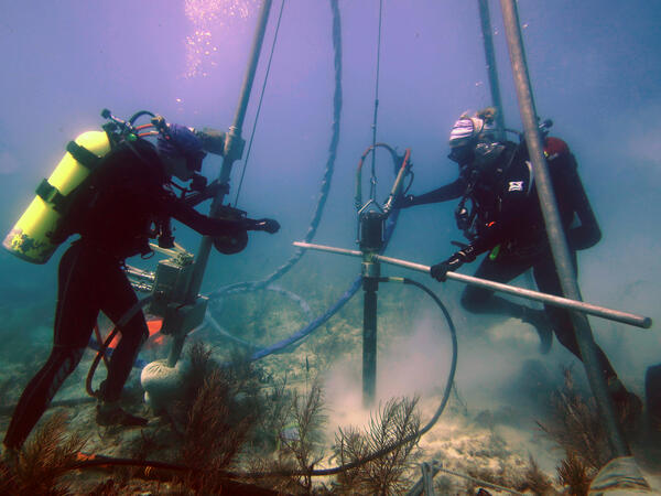
Research Oceanographer Lauren Toth and student volunteer Liz Whitcher drill a coral-reef core from a reef off Key West, Florida, in the Florida Keys National Marine Sanctuary. Photo taken under research permit FKNMS-2015-058. Credit: Anastasios Stathakopoulos, USGS.
Research Oceanographer Lauren Toth and student volunteer Liz Whitcher drill a coral-reef core from a reef off Key West, Florida, in the Florida Keys National Marine Sanctuary. Photo taken under research permit FKNMS-2015-058. Credit: Anastasios Stathakopoulos, USGS.

Jenny McKee and Peter Dal Farro of the USGS Pacific Coastal and Marine Science Center swing a pair of seismic sources, also called air guns, and the gun hanger, out over the water to deploy them during the 2018 MATRIX cruise. Scripps Institution of Oceanography's seismic streamer is coiled on the blue winch in the foreground.
Jenny McKee and Peter Dal Farro of the USGS Pacific Coastal and Marine Science Center swing a pair of seismic sources, also called air guns, and the gun hanger, out over the water to deploy them during the 2018 MATRIX cruise. Scripps Institution of Oceanography's seismic streamer is coiled on the blue winch in the foreground.

Jenny White McKee and Pete Dal Ferro of the Pacific Coastal and Marine Science Center retrieve two airguns during the 2018 MATRIX cruise aboard the R/V Hugh R. Sharp. The seismic streamer is visible on the winch in the foreground.
Jenny White McKee and Pete Dal Ferro of the Pacific Coastal and Marine Science Center retrieve two airguns during the 2018 MATRIX cruise aboard the R/V Hugh R. Sharp. The seismic streamer is visible on the winch in the foreground.

Four diesel-powered compressors chained to the deck of the R/V Hugh R. Sharp provided the air to power the seismic sources during the MATRIX cruise.
Four diesel-powered compressors chained to the deck of the R/V Hugh R. Sharp provided the air to power the seismic sources during the MATRIX cruise.

Unmanned Aerial Systems (UAS) demonstration at 2018 Woods Hole, MA Science Stroll
Unmanned Aerial Systems (UAS) demonstration at 2018 Woods Hole, MA Science Stroll

Sandy Brosnahan, Woods Hole Coastal and Marine Science Center, discusses Kilauea Volcano drone footage with Science Stroll participants
Sandy Brosnahan, Woods Hole Coastal and Marine Science Center, discusses Kilauea Volcano drone footage with Science Stroll participants

USGS drone demonstration at the 2018 Woods Hole, MA Science Stroll
USGS drone demonstration at the 2018 Woods Hole, MA Science Stroll

USGS drone demonstration at the 2018 Woods Hole, MA Science Stroll
USGS drone demonstration at the 2018 Woods Hole, MA Science Stroll

Woods Hole Coastal and Marine Science Center Unmanned Aerial Systems (UAS) demonstration, 2018 Woods Hole Science Stroll
Woods Hole Coastal and Marine Science Center Unmanned Aerial Systems (UAS) demonstration, 2018 Woods Hole Science Stroll

Sandy Baldwin, Woods Hole Coastal and Marine Science Center, shares video from the kilauea volcano with Science Stroll participants.
Sandy Baldwin, Woods Hole Coastal and Marine Science Center, shares video from the kilauea volcano with Science Stroll participants.

USGS display table at the 2018 Woods Hole, MA Science Stroll
USGS display table at the 2018 Woods Hole, MA Science Stroll

Woods Hole Coastal and Marine Science Center staff, Tarandeep Kalra (pointing in light blue shirt) and Zafer Defne (orange USGS shirt) discuss oceanographic models with Science Stroll attendees
Woods Hole Coastal and Marine Science Center staff, Tarandeep Kalra (pointing in light blue shirt) and Zafer Defne (orange USGS shirt) discuss oceanographic models with Science Stroll attendees

Sandy Brosnahan, Woods Hole Coastal and Marine Science Center's Aerial Imaging and Mapping project lead, shares the display screen of a drone in flight
Sandy Brosnahan, Woods Hole Coastal and Marine Science Center's Aerial Imaging and Mapping project lead, shares the display screen of a drone in flight

2018 Woods Hole, MA Science Stroll USGS drone demonstration
2018 Woods Hole, MA Science Stroll USGS drone demonstration

Engineering technician Jenny McKee from the USGS Pacific Coastal and Marine Science Center in Santa Cruz, California watches as an expendable sonobuoy leaves the launcher during the 2018 MATRIX cruise on research vessel Hugh R.
Engineering technician Jenny McKee from the USGS Pacific Coastal and Marine Science Center in Santa Cruz, California watches as an expendable sonobuoy leaves the launcher during the 2018 MATRIX cruise on research vessel Hugh R.

Entering Yaquina Bay, Oregon aboard the NOAA ship Rainier, approaching the Yaquina Bay Bridge with Newport Marina off to the right in the distance.
Entering Yaquina Bay, Oregon aboard the NOAA ship Rainier, approaching the Yaquina Bay Bridge with Newport Marina off to the right in the distance.

USGS personnel configuring and deploying the streamer of hydrophone receivers on the R/V Hugh R. Sharp during the MATRIX cruise. In foreground from left to right are Nathan Miller, Wayne Baldwin, and Eric Moore from the USGS Woods Hole Coastal and Marine Science Center.
USGS personnel configuring and deploying the streamer of hydrophone receivers on the R/V Hugh R. Sharp during the MATRIX cruise. In foreground from left to right are Nathan Miller, Wayne Baldwin, and Eric Moore from the USGS Woods Hole Coastal and Marine Science Center.

Sandy Brosnahan (left) and Ellizabeth Pendleton (right), Woods Hole Coastal and Marine Science Center Unmanned Aerial Systems (UAS) pilots flying drones at Sandy Neck Beach, Cape Cod, MA.
Sandy Brosnahan (left) and Ellizabeth Pendleton (right), Woods Hole Coastal and Marine Science Center Unmanned Aerial Systems (UAS) pilots flying drones at Sandy Neck Beach, Cape Cod, MA.

USGS Unmanned Aerial Systems (UAS) pilot, Elizabeth Pendleton, setting a target in Great Marsh, Sandy Neck Beach, Cape Cod, Massachusetts
USGS Unmanned Aerial Systems (UAS) pilot, Elizabeth Pendleton, setting a target in Great Marsh, Sandy Neck Beach, Cape Cod, Massachusetts