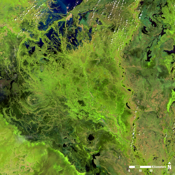
Landsat 8 image of South Sudan, showing portions of the states of Unity, Jonglei, and Warrup.
Image date: October 22, 2024
Path 174, Row 54
Band combination: 654

Official websites use .gov
A .gov website belongs to an official government organization in the United States.
Secure .gov websites use HTTPS
A lock () or https:// means you’ve safely connected to the .gov website. Share sensitive information only on official, secure websites.
Explore the images on this page to learn more about the Landsat sensors, satellites and missions.
Landsat 8 image of South Sudan, showing portions of the states of Unity, Jonglei, and Warrup.
Image date: October 22, 2024
Path 174, Row 54
Band combination: 654
Landsat 8 image of South Sudan, showing portions of the states of Unity, Jonglei, and Warrup.
Image date: October 22, 2024
Path 174, Row 54
Band combination: 654
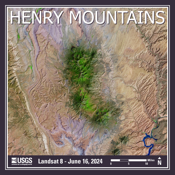
Landsat 8 image of the Henry Mountains in southeastern Utah.
Published on social media on November 7, 2024.
Mosaic of two different Landsat 8 images:
Image date: June 16, 2024
Path 37, Row 33 and Path 37, Row 34
Landsat 8 image of the Henry Mountains in southeastern Utah.
Published on social media on November 7, 2024.
Mosaic of two different Landsat 8 images:
Image date: June 16, 2024
Path 37, Row 33 and Path 37, Row 34

The attendees of the Landsat Ground Station Operators Working Group (LGSOWG) #52 meeting in Canberra, Australia in November 2024.
Visit this USGS webpage to learn more about LGSOWG #52.
The attendees of the Landsat Ground Station Operators Working Group (LGSOWG) #52 meeting in Canberra, Australia in November 2024.
Visit this USGS webpage to learn more about LGSOWG #52.
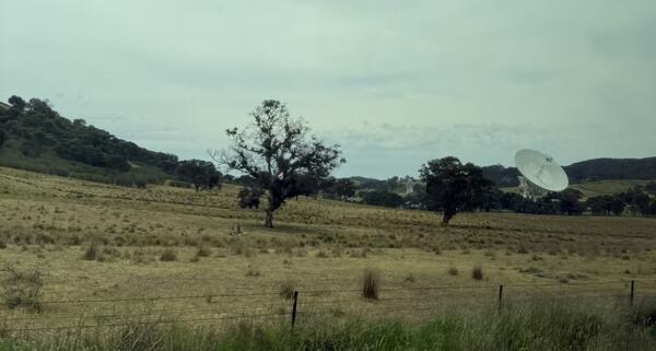
A picture of an antenna at the Canberra Deep Space Communications Complex (DSCC) located at Tidbinbilla, Australia. Hi. this is text.
The attendees of the Landsat Ground Station Operators Working Group (LGSOWG) #52 meeting visited the DSCC in early November 2024,
A picture of an antenna at the Canberra Deep Space Communications Complex (DSCC) located at Tidbinbilla, Australia. Hi. this is text.
The attendees of the Landsat Ground Station Operators Working Group (LGSOWG) #52 meeting visited the DSCC in early November 2024,

This graphic displays an example query created using information from the Querying the Landsat SpatioTemporal Asset Catalog with PySTAC tutorial.
This graphic displays an example query created using information from the Querying the Landsat SpatioTemporal Asset Catalog with PySTAC tutorial.
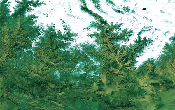
Landsat 9 image of the China-Mongolia border, showing parts of the autonomous region of Xinjiang, China, and Khovd Province, Mongolia.
Image date: October 23, 2024
Path 141, Row 28
Landsat 9 image of the China-Mongolia border, showing parts of the autonomous region of Xinjiang, China, and Khovd Province, Mongolia.
Image date: October 23, 2024
Path 141, Row 28

Las Vegas, Nevada and the area surrounding has been and remains a popular region of interest when showcasing urban growth and land change using Landsat sensors.
Las Vegas, Nevada and the area surrounding has been and remains a popular region of interest when showcasing urban growth and land change using Landsat sensors.
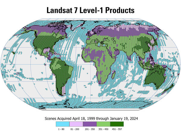
Nearly 3.4 million Landsat 7 Level-1 products are available for download from the USGS Earth Resources Observation and Science (EROS) Center archive. This map displays the density of the available Level-1 products acquired by Landsat 7 from April 1999 through January 2024.
Nearly 3.4 million Landsat 7 Level-1 products are available for download from the USGS Earth Resources Observation and Science (EROS) Center archive. This map displays the density of the available Level-1 products acquired by Landsat 7 from April 1999 through January 2024.
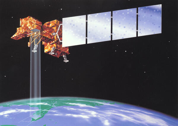
This is an illustration of the Landsat 7 satellite acquiring imagery of the Earth from space.
This is an illustration of the Landsat 7 satellite acquiring imagery of the Earth from space.

A September 20, 2024, Landsat 9 satellite image of eutrophication in Lake Thompson, South Dakota. Eutrophication because of phosphate fertilizer use is probably one of the most notable impacts on the environment, society and the economy.
A September 20, 2024, Landsat 9 satellite image of eutrophication in Lake Thompson, South Dakota. Eutrophication because of phosphate fertilizer use is probably one of the most notable impacts on the environment, society and the economy.

See your name in Landsat imagery!
This image was created using NASA's "Your Name in Landsat". Check it out at https://landsat.gsfc.nasa.gov/apps/YourNameInLandsat-main/index.html.
See your name in Landsat imagery!
This image was created using NASA's "Your Name in Landsat". Check it out at https://landsat.gsfc.nasa.gov/apps/YourNameInLandsat-main/index.html.

Tarrabool Lake is a seasonal lake in Australia’s Northern Territory. While the lake’s water level fluctuates from year to year, its swampy wetlands and the surrounding tropical forested areas supports an essential habitat for small mammals, reptiles, and a wide variety of bird species.
Tarrabool Lake is a seasonal lake in Australia’s Northern Territory. While the lake’s water level fluctuates from year to year, its swampy wetlands and the surrounding tropical forested areas supports an essential habitat for small mammals, reptiles, and a wide variety of bird species.

The Park Fire north of Sacramento in California forced thousands of residents to evacuate in late July as it spread to over 370,000 acres. The fire started on July 24th. Landsat 8 captured an image of the fire two days later.
The Park Fire north of Sacramento in California forced thousands of residents to evacuate in late July as it spread to over 370,000 acres. The fire started on July 24th. Landsat 8 captured an image of the fire two days later.

Ocean currents, and the sediments they transport, have constantly shifted the Cape Cod barrier islands over time. Some of the abrupt changes, however, can be linked directly to a storm.
Ocean currents, and the sediments they transport, have constantly shifted the Cape Cod barrier islands over time. Some of the abrupt changes, however, can be linked directly to a storm.

Minister for Foreign Affairs, Penny Wong, and U.S. Secretary of State, Antony Blinken, with the signed bilateral statement on the Landsat Next program.
Minister for Foreign Affairs, Penny Wong, and U.S. Secretary of State, Antony Blinken, with the signed bilateral statement on the Landsat Next program.

Alison Rose, Chief of Space Division, Geoscience Australia, and Darcee Killpack, acting Associate Director, Core Science Systems, United States Geological Survey, signing the Memorandum of Understanding formally operationalizing the Landsat Next partnership.
Alison Rose, Chief of Space Division, Geoscience Australia, and Darcee Killpack, acting Associate Director, Core Science Systems, United States Geological Survey, signing the Memorandum of Understanding formally operationalizing the Landsat Next partnership.

Minister for Foreign Affairs, Penny Wong, and U.S. Secretary of State, Antony Blinken, with the signed bilateral statement on the Landsat Next program.
Minister for Foreign Affairs, Penny Wong, and U.S. Secretary of State, Antony Blinken, with the signed bilateral statement on the Landsat Next program.

The Phoenix, Arizona metropolitan area, also known as the Valley of the Sun, is comprised of more than 14,600 square miles and is considered the largest metropolitan area in the southwestern United States. The desert climate and abundant sunshine of the area are main factors in population growth and urban sprawl.
The Phoenix, Arizona metropolitan area, also known as the Valley of the Sun, is comprised of more than 14,600 square miles and is considered the largest metropolitan area in the southwestern United States. The desert climate and abundant sunshine of the area are main factors in population growth and urban sprawl.

Screen capture of the Queensland WetlandMaps website for the landscape around the Diamantina National park in Queensland, for which DEA WIT data can be viewed for selected wetlands. WetlandMaps (des.qld.gov.au)
Screen capture of the Queensland WetlandMaps website for the landscape around the Diamantina National park in Queensland, for which DEA WIT data can be viewed for selected wetlands. WetlandMaps (des.qld.gov.au)

The Railroad Valley Playa, located in east central Nevada, measures about 80 miles long and nearly 20 miles wide, and is a vast and wide-open landscape.
The Railroad Valley Playa, located in east central Nevada, measures about 80 miles long and nearly 20 miles wide, and is a vast and wide-open landscape.
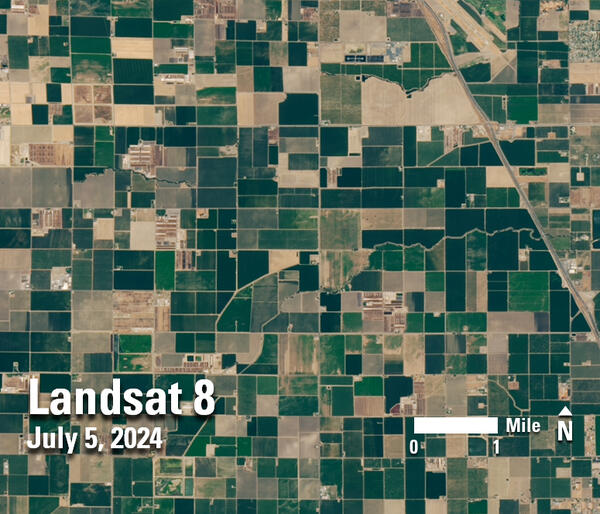
Landsat 8 image of central California cropland and dairies, southeast of Fresno, on July 5, 2024.
Landsat 8 image of central California cropland and dairies, southeast of Fresno, on July 5, 2024.