
Damage from a major post-wildfire landslide that occurred on 25 December 2003 near Devore, San Bernardino County as a result of the Old/Grand Prix fires that ran through the San Bernardino Mountains.
Images
Images related to natural hazards.
Filter Total Items: 7275

Debris flow after the 2003 Old Gran Prix fire
Damage from a major post-wildfire landslide that occurred on 25 December 2003 near Devore, San Bernardino County as a result of the Old/Grand Prix fires that ran through the San Bernardino Mountains.

USGS marine technicians launch a hydrophone off Puerto Rico seafloor
USGS marine technicians launch a hydrophone off Puerto Rico seafloorUSGS marine technicians Alex Nichols (L) and Eric Moore (R) deploy the hydrophone array on a seismic research cruise off the southwest coast of Puerto Rico aboard the R/V Sultana in March 2020.

Three scientists launch a "sparker" used in seafloor mapping
Three scientists launch a "sparker" used in seafloor mappingUSGS research geologist Jason Chaytor (L) and marine technicians Alex Nichols (center) and Eric Moore (R) deploy the “sparker” sound source on a seismic research cruise off the southwest coast of Puerto Rico aboard the R/V Sultana in March 2020.

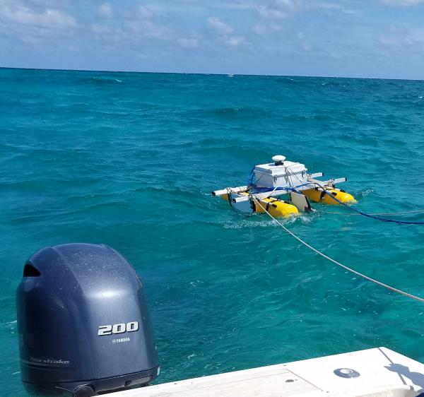
Deploying streamer
Alex Nichols, Wayne Baldwin, and Eric Moore deploying a streamer in Puerto Rico.
Alex Nichols, Wayne Baldwin, and Eric Moore deploying a streamer in Puerto Rico.

Scientist launches instrument used to map seafloor off Puerto Rico
Scientist launches instrument used to map seafloor off Puerto RicoUSGS marine technician Wayne Baldwin prepares to deploy the hydrophone array during a seismic research cruise off the southwest coast of Puerto Rico on board the R/V Sultana in March 2020.

Woods Hole Coastal and Marine Science Center Sediment Analysis Lab
Woods Hole Coastal and Marine Science Center Sediment Analysis LabView inside the Woods Hole Coastal and Marine Science Center Sediment Analysis Laboratory showing the laboratory computer workstation, precision balances, and interior of the oven and sieving room.

Woods Hole Sediment Analysis Lab
View inside the Woods Hole Coastal and Marine Science Center Sediment Analysis Laboratory showing the Beckman Coulter Multisizer 3 and Horiba LA-960 laser diffraction unit.
View inside the Woods Hole Coastal and Marine Science Center Sediment Analysis Laboratory showing the Beckman Coulter Multisizer 3 and Horiba LA-960 laser diffraction unit.

Mushroom Pool, in the Lower Geyser Basin of Yellowstone National Park. The pool
Mushroom Pool, in the Lower Geyser Basin of Yellowstone National Park. The poolMushroom Pool, in the Lower Geyser Basin of Yellowstone National Park, as it looked in June 23, 1967. The sample that would be the source of Thermus aquaticus strain YT-1 came from this hot spring. Pictured is Thomas Brock standing near the edge of the pool. Image from the self-published "A Scientist in Yellowstone National Park" (Brock, 2017).

Timelapse of water rising in Halema‘uma‘u
This timelapse sequence shows the water pond in Halema‘uma‘u Crater, at Kīlauea's summit, between November 1, 2019, and March 26, 2020. Over this time the water level rose approximately 14 meters (46 feet), equivalent to 67 cm (about 2 feet) per week. The timelapse shows one image per day (with a few cloudy images removed), and is looped several times.
This timelapse sequence shows the water pond in Halema‘uma‘u Crater, at Kīlauea's summit, between November 1, 2019, and March 26, 2020. Over this time the water level rose approximately 14 meters (46 feet), equivalent to 67 cm (about 2 feet) per week. The timelapse shows one image per day (with a few cloudy images removed), and is looped several times.

Davina Passeri presents poster about coastal change research
Davina Passeri presents poster about coastal change researchDavina Passeri of the St. Petersburg Coastal and Marine Science Center presents a poster about coastal change research in Dauphin Island, Alabama at the USGS Southeast Regional Meeting in February 2020.

Ilsa Kuffner presents a poster on coral research
Ilsa Kuffner speaks to a group at the USGS Southeast Regional Meeting in February 2020 about coral research conducted by the St. Petersburg Coastal and Marine Science Center
Ilsa Kuffner speaks to a group at the USGS Southeast Regional Meeting in February 2020 about coral research conducted by the St. Petersburg Coastal and Marine Science Center

Kathryn Smith at an Outreach Event
The USGS St. Petersburg Coastal and Marine Science Center conducted outreach at the Localtopia Event held in February 2020. Staff demonstrated a simulation of how storms can impact sandy coastlines through processes such as erosion.
The USGS St. Petersburg Coastal and Marine Science Center conducted outreach at the Localtopia Event held in February 2020. Staff demonstrated a simulation of how storms can impact sandy coastlines through processes such as erosion.

Water, ash, and the great unknown of explosive volcanic eruptions
Water, ash, and the great unknown of explosive volcanic eruptionsScanning electron microprobe images show the complexity of tiny Icelandic ash grains (150 micron, or 0.006 inch). Image (a) shows a dense and blocky grain, and (b) shows a foamy grain. Photos by J. Schmith.

Answer: a GPS capable of accurately measuring elevations to within 10 cm (~4 in)
Answer: a GPS capable of accurately measuring elevations to within 10 cm (~4 in)Answer: a GPS capable of accurately measuring elevations to within 10 cm (~4 in). In the summer of 2019, USGS organized a Light Detection and Ranging (LiDAR) survey of the Kīlauea summit and East Rift Zone, including both the Pu‘u ‘Ō‘ō and 2018 lower Puna lava flows.
SQUID-5 - Structure-from-Motion Quantitative Underwater Imaging Device
SQUID-5 - Structure-from-Motion Quantitative Underwater Imaging DeviceThe SQUID-5, or a Structure-from-Motion (SfM) Quantitative Underwater Imaging Device with 5 cameras is a towed surface vehicle with an onboard Global Navigation Satellite System (GNSS) and 5 downward-looking cameras with overlapping views of the seafloor.

HVO scientists conduct field checks of LiDAR survey
HVO scientists conduct field checks of LiDAR surveyQuestion: what's that in the shrubs?
HVO scientists conduct field checks of LiDAR survey
HVO scientists conduct field checks of LiDAR surveyQuestion: what's that in the shrubs?

State of Our Nation’s Coast Stakeholder Engagement Workshop
State of Our Nation’s Coast Stakeholder Engagement WorkshopA group of participants at the Coastal Change Hazards State of Our Nation’s Coast stakeholder engagement workshop at the Waquoit Bay National Estuarine Reserve in Falmouth, MA. Here participants are pictured writing the names of tools they use on sticky notes.

State of Our Nation’s Coast Stakeholder Engagement Workshop
State of Our Nation’s Coast Stakeholder Engagement WorkshopParticipants of the Coastal Change Hazards State of Our Nation’s Coast stakeholder engagement workshop at the Waquoit Bay National Estuarine Reserve in Falmouth, MA. Participants are pictured here talking in small groups.

CTD rosette being deployed
A CTD-rosette is a commonly used instrument that measures conductivity (that can inform scientists about salinity), temperature, and depth (CTD). As the instrument is lowered into the water--sometimes down to great depths--the cylinders around will open at various depths to collect water samples at discrete locations throughout the water column.
A CTD-rosette is a commonly used instrument that measures conductivity (that can inform scientists about salinity), temperature, and depth (CTD). As the instrument is lowered into the water--sometimes down to great depths--the cylinders around will open at various depths to collect water samples at discrete locations throughout the water column.

Sunset on a research vessel in the Gulf of Mexico
A beautiful sun set over the Gulf of Mexico from the stern of the R/V Pelican.
A beautiful sun set over the Gulf of Mexico from the stern of the R/V Pelican.

Guide describes general protocols and provides templates for news media manageme
Guide describes general protocols and provides templates for news media managemeUSGS Cascades Volcano Observatory News Media Management Guide—General Protocols and Templates, USGS Circular 1462 (https://pubs.er.usgs.gov/publication/cir1462) provides protocols and templates for (1) normal conditions when CVO has an opportunity to be proactive with its messages and to raise general awaren