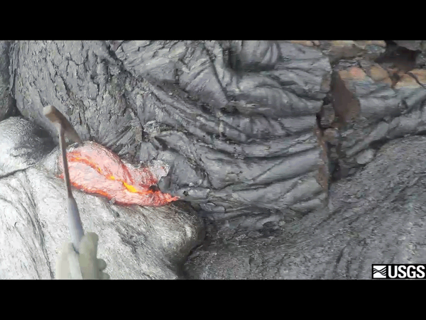
U.S. flag

An official website of the United States government

Images

Images related to natural hazards.

Filter Total Items: 7271
Five different flows—two erupted prehistorically and three others e...

To construct a geologic map of this area, USGS Hawaiian Volcano Observatory geologists initially used lava flow type, rock colors, and relative stratigraphic positions to distinguish between individual lava flows, and then relied on laboratory analyses and age-dates of the flows to refine their field mapping. USGS photo.

To construct a geologic map of this area, USGS Hawaiian Volcano Observatory geologists initially used lava flow type, rock colors, and relative stratigraphic positions to distinguish between individual lava flows, and then relied on laboratory analyses and age-dates of the flows to refine their field mapping. USGS photo.

Several small collapses as summit lava lake slowly drops...
Several small collapses as summit lava lake slowly drops

Summit deflation over the past day was associated with the summit lava lake level slowly dropping. When this happens, collapses commonly occur within the Overlook crater. Solidified lava, attached to the Overlook crater walls, collapsed into the lake on several occasions today, triggering small dust plumes and agitation of the lake surface.

Summit deflation over the past day was associated with the summit lava lake level slowly dropping. When this happens, collapses commonly occur within the Overlook crater. Solidified lava, attached to the Overlook crater walls, collapsed into the lake on several occasions today, triggering small dust plumes and agitation of the lake surface.

Geologic mapping looks to the past to reveal the future...
Geologic mapping looks to past to reveal the future

An HVO field geologist must make his way through dense forest to map the full extent of an old Mauna Loa lava flow. USGS photo.

Landsat satellite image shows June 27th lava flow...
Landsat satellite image shows June 27th lava flow

This satellite image was captured on Tuesday, October 13, 2015 by the Landsat 8 satellite. Although this is a false-color image, the color map has been chosen to mimic what the human eye would expect to see. Bright red pixels depict areas of very high temperatures and show active lava. White areas are clouds.

This satellite image was captured on Tuesday, October 13, 2015 by the Landsat 8 satellite. Although this is a false-color image, the color map has been chosen to mimic what the human eye would expect to see. Bright red pixels depict areas of very high temperatures and show active lava. White areas are clouds.

A diver peeks from behind a badly bleached coral in the Florida Keys National Marine Sanctuary in October 2015
Bleached mountainous star coral at Hen and Chickens Sanctuary

A diver peeks from behind a badly bleached coral in the Florida Keys National Marine Sanctuary in October 2015. Coral bleaching events caused by abnormally warm ocean temperatures continue to regularly claim the lives of coral populations around the globe. 

A diver peeks from behind a badly bleached coral in the Florida Keys National Marine Sanctuary in October 2015. Coral bleaching events caused by abnormally warm ocean temperatures continue to regularly claim the lives of coral populations around the globe. 

Lessons learned from the 2006 Kīholo Bay earthquakes...
Lessons learned from the 2006 Kīholo Bay earthquakes

A Hawaiian Volcano Observatory volunteer demonstrates "Drop! Cover! Hold on!"—actions that can reduce injuries or prevent death during an earthquake.

A Hawaiian Volcano Observatory volunteer demonstrates "Drop! Cover! Hold on!"—actions that can reduce injuries or prevent death during an earthquake.

Lessons learned from the 2006 Kīholo Bay earthquakes...
Lessons learned from the 2006 Kīholo Bay earthquakes

Graphic from the Great Hawaii ShakeOut website (http://shakeout.org/hawaii/) showing the recommended actions to protect yourself during an earthquake.

Image: USGS Scientist Inspects Streamgage During Flooding Event
USGS Scientist Inspects Streamgage During Flooding Event

USGS scientist Matt Jennings inspects streamgage number  02136361 at Turkey Creek near Maryville, South Carolina, the morning of October 4, 2015. The discharge they measured was 6,000 cfs.

USGS scientist Matt Jennings inspects streamgage number  02136361 at Turkey Creek near Maryville, South Carolina, the morning of October 4, 2015. The discharge they measured was 6,000 cfs.

Small-scale map of flow field...
Small-scale map of flow field

This small-scale map shows Kīlauea's active East Rift Zone lava flow in relation to the eastern part of the Island of Hawai‘i. The area of the flow on September 11 is shown in pink, while widening and advancement of the flow as of September 30 is shown in red. The yellow lines show the active lava tube system.

This small-scale map shows Kīlauea's active East Rift Zone lava flow in relation to the eastern part of the Island of Hawai‘i. The area of the flow on September 11 is shown in pink, while widening and advancement of the flow as of September 30 is shown in red. The yellow lines show the active lava tube system.

Map showing flow field changes...
Map showing flow field changes

This map shows recent changes to Kīlauea's active East Rift Zone lava flow field. The area of the flow on September 11 is shown in pink, while widening and advancement of the flow as of September 30 (based on satellite imagery) is shown in red. The yellow lines show the active lava tube system.

This map shows recent changes to Kīlauea's active East Rift Zone lava flow field. The area of the flow on September 11 is shown in pink, while widening and advancement of the flow as of September 30 (based on satellite imagery) is shown in red. The yellow lines show the active lava tube system.

A repeating loop showing a hammer scooping lava from a flow and dropping it into a bucket.
Lava Sampling
Lava Sampling
Lava Sampling

This is an animated GIF, taken from a longer video, showing the moment that this geologist from the Hawaiian Volcano Observatory (HVO) scoops up lava from an active flow and drops it into a bucket of water to cool it down. 

This is an animated GIF, taken from a longer video, showing the moment that this geologist from the Hawaiian Volcano Observatory (HVO) scoops up lava from an active flow and drops it into a bucket of water to cool it down. 

HVO geologists hike through thick fume and fog to reach the lava po...
Geologists hike through thick fume and fog to reach the lava pond i...

HVO geologists hike through thick fume and fog to reach the lava pond in the western portion of Pu‘u ‘Ō‘ō crater.

Scattered breakouts remain active northeast of Pu‘u ‘Ō‘ō...
Scattered breakouts remain active NE of Pu‘u ‘Ō‘ō

The June 27th lava flow remains active with scattered breakouts northeast of Pu‘u ‘Ō‘ō. The farthest active breakout today was about 6.5 km (4 miles) from Pu‘u ‘Ō‘ō. This photograph shows activity along the northern flow boundary, where breakouts continue to burn vegetation.

The June 27th lava flow remains active with scattered breakouts northeast of Pu‘u ‘Ō‘ō. The farthest active breakout today was about 6.5 km (4 miles) from Pu‘u ‘Ō‘ō. This photograph shows activity along the northern flow boundary, where breakouts continue to burn vegetation.

This Quicktime video shows lava sample collection from the perspect...
Lava sample collection from the perspective of an Geologist
No major changes in the lava lake at Halema‘uma‘u Crater...
No major changes in the lava lake at Halema‘uma‘u

This wide view shows the lava lake active within the Overlook crater, which is set within the larger Halema‘uma‘u Crater. There have been no major changes in the lake in recent weeks. This morning the lava lake was roughly 60 meters (200 feet) below the rim of the Overlook crater.

This wide view shows the lava lake active within the Overlook crater, which is set within the larger Halema‘uma‘u Crater. There have been no major changes in the lake in recent weeks. This morning the lava lake was roughly 60 meters (200 feet) below the rim of the Overlook crater.

This view looks west towards Pu‘u ‘Ō‘ō, which can be seen in the up...

This view looks west towards Pu‘u ‘Ō‘ō, which can be seen in the upper left. The most distant active breakouts today were located near the center of the photograph, at a spot roughly 6.5 km (4 miles) from Pu‘u ‘Ō‘ō.

This view looks west towards Pu‘u ‘Ō‘ō, which can be seen in the upper left. The most distant active breakouts today were located near the center of the photograph, at a spot roughly 6.5 km (4 miles) from Pu‘u ‘Ō‘ō.

A closer look at the lava lake in the Overlook crater....
lava lake in the Overlook crater.
Bottled soda helps us to understand volcanic eruptions...
Bottled soda helps us to understand volcanic eruptions

Replica of a 19th century soda bottle that was sealed with a blue marble (visible in lower crimp of the bottle). Bottles like this played a part in creating the bottled soda analogy of how and why volcanoes erupt. The Halema‘uma‘u Overlook gas plume is visible in the background. USGS photo.

Replica of a 19th century soda bottle that was sealed with a blue marble (visible in lower crimp of the bottle). Bottles like this played a part in creating the bottled soda analogy of how and why volcanoes erupt. The Halema‘uma‘u Overlook gas plume is visible in the background. USGS photo.

Was this page helpful?