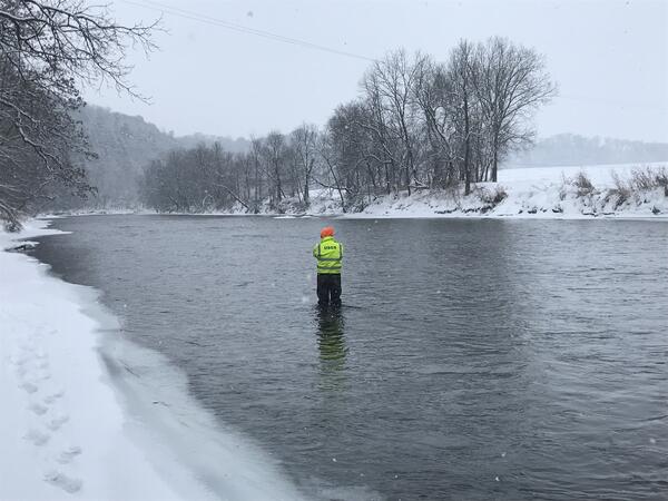
Routine measurement at USGS stream gage 05383950 Root River, MN
Routine measurement at USGS stream gage 05383950 Root River, MNPatrick Farrell makes a snowy, routine measurement at USGS stream gage 05383950 Root River near Pilot Mount, MN.

Official websites use .gov
A .gov website belongs to an official government organization in the United States.
Secure .gov websites use HTTPS
A lock () or https:// means you’ve safely connected to the .gov website. Share sensitive information only on official, secure websites.
Explore water-related photography, imagery, and illustrations.
Patrick Farrell makes a snowy, routine measurement at USGS stream gage 05383950 Root River near Pilot Mount, MN.
Patrick Farrell makes a snowy, routine measurement at USGS stream gage 05383950 Root River near Pilot Mount, MN.

Travis Gibson services the SonTek SW prior to making a discharge measurement on a chilly morning on the Great Salt Lake at USGS gage 410401112134801 Great Salt Lake Farmington Bay Outflow, UT.
Travis Gibson services the SonTek SW prior to making a discharge measurement on a chilly morning on the Great Salt Lake at USGS gage 410401112134801 Great Salt Lake Farmington Bay Outflow, UT.

Ever wondered about how groundwater observation wells are drilled? This photo provides a behind-the-scenes look as USGS drilled a groundwater well in California last month. This photo looks down over a mud tank and shakers, which are part of drilling operations.
Ever wondered about how groundwater observation wells are drilled? This photo provides a behind-the-scenes look as USGS drilled a groundwater well in California last month. This photo looks down over a mud tank and shakers, which are part of drilling operations.
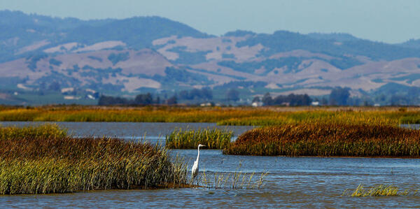
Photo of the San Francisco Bay Estuary. This photo show wetlands and waterfowl.
Photo of the San Francisco Bay Estuary. This photo show wetlands and waterfowl.

Lab Instrumentation used for target analyses at the OGRL at the KS WSC. Image is of part of the Instrument Laboratory.
Lab Instrumentation used for target analyses at the OGRL at the KS WSC. Image is of part of the Instrument Laboratory.

Photograph taken for a USGS project to collect imagery, topographic, and bathymetric data and sources of water and salts of Zuni Salt Lake in west-central New Mexico, 2019.
Photograph taken for a USGS project to collect imagery, topographic, and bathymetric data and sources of water and salts of Zuni Salt Lake in west-central New Mexico, 2019.

USGS gage 05293000 YELLOW BANK RIVER NEAR ODESSA, MN with High River Water Level From Flood.
USGS gage 05293000 YELLOW BANK RIVER NEAR ODESSA, MN with High River Water Level From Flood.


A 4" aluminum I-beam is used allow an ADVM to be raised and lowered on a stainless steel sled.
A 4" aluminum I-beam is used allow an ADVM to be raised and lowered on a stainless steel sled.

Temporary mount for installation of a horizontal ADVM under ice. A large flange serves as a load bearing base plate with 2" pipe and pipe fittings being used to suspend the ADVM below.
Temporary mount for installation of a horizontal ADVM under ice. A large flange serves as a load bearing base plate with 2" pipe and pipe fittings being used to suspend the ADVM below.

Diagram depicting stationing in midsection measurement where velocity measurements are acquired. Each station width is multiplied by the station depth and measured velocity to compute the discharge in each section. Section discharges are tabulated to compute a total discharge for the cross section.
Diagram depicting stationing in midsection measurement where velocity measurements are acquired. Each station width is multiplied by the station depth and measured velocity to compute the discharge in each section. Section discharges are tabulated to compute a total discharge for the cross section.

Missouri boat and mount.

A well at a restored prairie on Lake Agassiz beach ridge, Glacial Ridge National Wildlife Refuge
A well at a restored prairie on Lake Agassiz beach ridge, Glacial Ridge National Wildlife Refuge

Morning fog over beach ridges at Glacial Ridge National Wildlife Refuge
Morning fog over beach ridges at Glacial Ridge National Wildlife Refuge

Prairie Dog, Glacial Ridge National Wildlife Refuge
Prairie Dog, Glacial Ridge National Wildlife Refuge


Example of a camera system that will be tested to measure water level and surface velocity at the East Branch Brandywine Creek below Downingtown, PA.
Example of a camera system that will be tested to measure water level and surface velocity at the East Branch Brandywine Creek below Downingtown, PA.

A 4" aluminum I-beam is used allow an ADVM to be raised and lowered on a stainless steel sled. The I-beam also serves as a pedestal mount for electronics housing.
A 4" aluminum I-beam is used allow an ADVM to be raised and lowered on a stainless steel sled. The I-beam also serves as a pedestal mount for electronics housing.

Top view of beam orientation and sample volume of a sidelooking ADVM. The ADVM-measured velocity used to index mean velocity is usually the sample volume x-component of velocity.
Top view of beam orientation and sample volume of a sidelooking ADVM. The ADVM-measured velocity used to index mean velocity is usually the sample volume x-component of velocity.

2" galvanzied pipe mated to a custom PVC clamp mount are used to fasten a horizontal ADVM.
2" galvanzied pipe mated to a custom PVC clamp mount are used to fasten a horizontal ADVM.