U.S. flag

An official website of the United States government

Images

California Volcano Observatory images.

Filter Total Items: 196
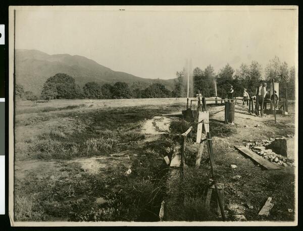
A sepia-toned historical photograph shows an open field with people standing near a row of wooden-framed well structures and pipes. A thin jet of gas or water sprays upward from two of the wells. Forested hills and a mountain rise in the background.
Kelseyville Gas Wells, ca.1910

Photograph of men at the Kelseyville Gas Wells, ca.1910, by M. Rieder. Courtesy of California Historical Society Collection, University of Southern California Digital Libraries. 

Photograph of men at the Kelseyville Gas Wells, ca.1910, by M. Rieder. Courtesy of California Historical Society Collection, University of Southern California Digital Libraries. 

A black-and-white stereograph photo pair shows a horse-drawn cart advancing toward the photographer on a muddy dirt road. In the middle ground, an early-20th century hotel is flanked by other small shops and a single telegraph pole. In the background, a double-peaked snow clad mountain rises high above the town, faded with distance.
Stereograph photo of Mount Shasta and the town of Sisson in 1906

Horse-drawn carriage on road in Sisson, California, El Monte Hotel in foreground, Mount Shasta in the background. Image courtesy of the Library of Congress.

Photograph of the town of Sisson (later (1922) the town of Mt. Shasta) in the distance at the foot of Mount Shasta in winter. Snow covered fir trees in the foreground.
Town of Sisson at the foot of Mount Shasta in winter, ca.1900

Photograph of the town of Sisson (later (1922) the town of Mt. Shasta) in the distance at the foot of Mount Shasta in winter. Snow covered fir trees in the foreground. Photo courtesy of University of Southern California Libraries and California Historical Society. Digitally reproduced by the USC Digital Library.

Photograph of the town of Sisson (later (1922) the town of Mt. Shasta) in the distance at the foot of Mount Shasta in winter. Snow covered fir trees in the foreground. Photo courtesy of University of Southern California Libraries and California Historical Society. Digitally reproduced by the USC Digital Library.

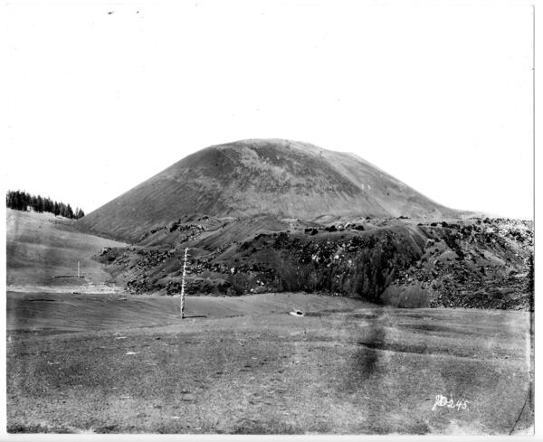
A historic black-and-white photo shows a small, round mountain made up of barren rocks. A huge lava flow spreads from its base, sparsely dotted by spindly pine trees.
Cinder Cone volcano in the Lassen Volcanic Center

This photo of the Cinder Cone scoria cone volcano north of Lassen Peak was taken in 1889 by Joseph Diller, an early USGS and National Parks geologist. Photo courtesy of the National Park Service.

This photo of the Cinder Cone scoria cone volcano north of Lassen Peak was taken in 1889 by Joseph Diller, an early USGS and National Parks geologist. Photo courtesy of the National Park Service.

Infographic about the 2019 report "California's Exposure to Volcanic Hazards"
California's Exposure to Volcanic Hazards

Infographic about the 2019 report "California's Exposure to Volcanic Hazards"

USGS Director Jim Reilly being given a tour of the CalVO Ops room by Emily Montgomery-Brown
USGS Director Jim Reilly being given a tour of the CalVO

In a February 5, 2019 visit, USGS Director Jim Reilly was given a tour of CalVO facilities, including the Operations Room. Here Emily Montgomery-Brown explains the networks that monitor California's threatening volcanoes.

In a February 5, 2019 visit, USGS Director Jim Reilly was given a tour of CalVO facilities, including the Operations Room. Here Emily Montgomery-Brown explains the networks that monitor California's threatening volcanoes.

Was this page helpful?