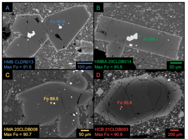
A subduction zone is formed where two tectonic plates come together and one plate overrides the other. The plate with lower density, usually comprised of continental crust, stays on top while the denser plate, usually made of oceanic crust, is pushed and pulled beneath, into Earth’s mantle.
Images
California Volcano Observatory images.
A subduction zone is formed where two tectonic plates come together and one plate overrides the other. The plate with lower density, usually comprised of continental crust, stays on top while the denser plate, usually made of oceanic crust, is pushed and pulled beneath, into Earth’s mantle.
A spreading center is formed where two tectonic plates are moving away from each other. Magma from the mantle upwells to fill the space made by the diverging plates, and erupts at the boundary to form new crust.
The Salton Buttes volcanic field is the youngest and southernmost of the fields associated with the North American and Pacific plate boundary. Five obsidian rhyolite domes erupted on the southern shore of the Salton Sea between 6000 and 500 years ago. The area is active geothermally and seismically, with numerous hot springs and mudpots on the surface.
The Mendocino Triple Junction is a tectonic boundary where three plates (the Pacific, North American, and Juan De Fuca) meet.
Transform boundaries are formed where two tectonic plates pass laterally by one another. These boundaries are commonly defined by a series of faults, each of which accommodates some of the translational movement between passing plates. Small bends in these boundaries led to the formation of mountains and valleys.
Sampling molten lava from the middle East Rift Zone Kīlauea eruption in Nāpau Crater, September 17, 2024
Sampling molten lava from the middle East Rift Zone Kīlauea eruption in Nāpau Crater, September 17, 2024USGS Hawaiian Volcano Observatory geologists collected a sample of the middle East Rift Zone Kīlauea eruption in Nāpau Crater, within a closed area Hawaiʻi Volcanoes National Park. Geologists put molten lava into a metal bucket and rapidly quench it with water.
Eddy covariance monitoring station at Horseshoe Lake, Mammoth Mountain, California
Eddy covariance monitoring station at Horseshoe Lake, Mammoth Mountain, CaliforniaThe eddy covariance station shown in this photo has been continuously measuring CO₂ emissions since 2014, providing half-hourly measurements of volcanic gas flux. Unlike previous seasonal monitoring that was limited by snowpack, this 6-meter-tall tower setup with commercial power allows year-round operation - a first for volcanic gas monitoring in this environment.
On the Cascade crest 35 km north of Mount Shasta, Goosenest is a late Pleistocene andesitic cone about ~1,400 m (~4500 ft) tall. USGS photo by A. Pivarunas.
Whitney Creek on the slopes of Mount Shasta in northern California is regularly reshaped by debris flows, created by melting snow and ice or precipitation. Although the stream channel itself is relatively small, these flows are capable of carrying large volumes of volcanic debris, including boulders in excess of several meters. USGS photo by J. Ball.
Lenticular clouds form when moist air flows up the slopes of a volcano (or other peak), cools, and condenses. The resulting clouds often drop a bit after pushing over the summit, like an eddy over a rock in a stream, and create seemingly stationary shapes that hover over the landscape. USGS photo by Andrew Calvert.
Lassen Volcanic Center earthquake swarm of June 24, 2024
Lassen Volcanic Center earthquake swarm of June 24, 2024This map shows the location of the June 24, 2024 earthquake swarm at the Lassen Volcanic Center relative to Lassen Peak and Growler & Morgan Hot Springs. Earthquakes are indicated by white, blue, and yellow circles, scaled to the earthquake size.
LSIB helicorder trace from the Lassen Volcanic Center on June 24, 2024.
LSIB helicorder trace from the Lassen Volcanic Center on June 24, 2024.This digital helicorder record from station LSIB on the Northern California Seismic Network emphasizes the dozens of tiny earthquakes in Lassen's June 24 swarm. Earch line of the helicorder shows 15 minutes of time, with the entire record covering 24 hours.
Tuffisite veins form during eruptions, when a mix of hot volcanic gas and rock fragments are forced through fractures in cooled lava. USGS photo by J. Crozier.
Mono Craters consists of a series of high-silica rhyolite lava domes, many erupted within the last 10,000 years. The domes are often steep, glassy, and contain very few phenocrysts.
Rhyolite lava flow textures from Long Valley and Yellowstone calderas
Rhyolite lava flow textures from Long Valley and Yellowstone calderasRhyolite lava flow textures from Long Valley and Yellowstone calderas. A) Photograph of well-developed spherulites in a lava flow from Long Valley Caldera in Eastern California. This high-silica rhyolite flow is very similar to the Central Plateau Member rhyolites of the Yellowstone Plateau Volcanic Field and exhibits many of the same textures.
Mass spectrometer, used to measure the ration of atoms with different masses, in the USGS laboratory at Moffett Field, California
Mass spectrometer, used to measure the ration of atoms with different masses, in the USGS laboratory at Moffett Field, CaliforniaA mass spectrometer is used to measure the ratio of atoms with different masses—in this case, the different isotopes of argon gas, which can be used to determine the age of a volcanic rock. Left: a side view of a mass spectrometer at the USGS Argon Geochronology Laboratory in Moffett Field, CA. Right: a close-up view of the sample chamber in this mass spectrometer.
Microscopic view of different groundmass textures in rocks
Microscopic view of different groundmass textures in rocksMicroscopic view of different groundmass textures in rocks. On the left, this groundmass is a good choice for argon dating, as it consists of abundant interconnected crystals. On the right, the groundmass consists predominantly of glass (black because it does not transmit cross-polarized light) and is a poor choice for argon dating.
Laboratory Building 800 at Moffett Field, California
Laboratory Building 800 at Moffett Field, CaliforniaBuilding 800 at the USGS Moffett Field campus houses shared laboratory space for multiple science centers. USGS photo by Jessica Ball.
Laboratory Building 800 at Moffett Field, California
Laboratory Building 800 at Moffett Field, CaliforniaBuilding 800 at the USGS Moffett Field campus houses shared laboratory space for multiple science centers. USGS photo by Jessica Ball.
Inverted topography in the Clear Lake Volcanic Field
Inverted topography in the Clear Lake Volcanic FieldFrom this vantage point, the remnants of a Clear Lake volcanic field lava flow can be seen forming the prominent ridge across Highway 20. They are iron-rich and a popular location for vineyard cultivation.
Cerro San Luis Obispo, Islay Hills volcanic complex
Cerro San Luis Obispo, Islay Hills volcanic complexIslay Hills is a chain of peaks also known as the Nine Sisters (or “Morros”).
Cerro San Luis Obispo, Islay Hills volcanic complex
Cerro San Luis Obispo, Islay Hills volcanic complexIslay Hills is a chain of peaks also known as the Nine Sisters (or “Morros”).
Volcanic gas sampling at a mud pool, Salton Buttes, California
Volcanic gas sampling at a mud pool, Salton Buttes, CaliforniaTo sample volcanic gases, inverted funnels connected to an evacuated sample bottle by tubing are sealed over a fumarole. Painter's poles are used to reach gas vents across dangerous (hot, unstable, or fragile) ground.