U.S. flag

An official website of the United States government

Images

California Volcano Observatory images.

Filter Total Items: 183
This photo looks across an active rock quarry at a conical hill that has been mined, revealing a dark red interior
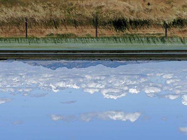
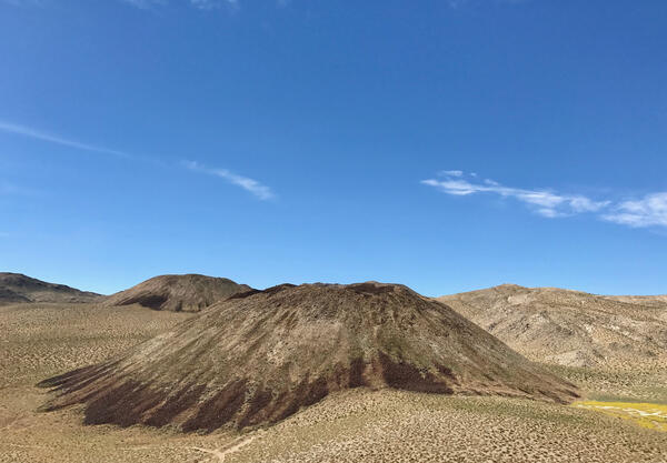
Clearlake Oaks cinder cone, Clear Lake Volcanic Field, California

Cinder cones (or scoria cones) are relatively small, steep-sided volcanoes that are constructed around a single vent when lava is ejected into the air, breaks into smaller pieces, and builds up around the sides of the vent. This photo is looking across the quarry which exposes the interior of a cinder cone east of Clearlake Oaks in the Clear Lake Volcanic Field.

Cinder cones (or scoria cones) are relatively small, steep-sided volcanoes that are constructed around a single vent when lava is ejected into the air, breaks into smaller pieces, and builds up around the sides of the vent. This photo is looking across the quarry which exposes the interior of a cinder cone east of Clearlake Oaks in the Clear Lake Volcanic Field.

A view on a clear day, looking down from a high volcanic peak at a cratered promontory in the blue waters of Clear Lake.
Buckingham Peninsula, Clear Lake, CA

Located at the midpoint of Clear Lake in Lake County, California, Buckingham Peninsula shows evidence of young explosive volcanism in the Clear Lake Volcanic Field. Little Borax Lake, enclosed within the Buckingham golf course, is a water-filled maar crater, as is Horseshoe Bay to its northeast. USGS photo by J. Ball.

Located at the midpoint of Clear Lake in Lake County, California, Buckingham Peninsula shows evidence of young explosive volcanism in the Clear Lake Volcanic Field. Little Borax Lake, enclosed within the Buckingham golf course, is a water-filled maar crater, as is Horseshoe Bay to its northeast. USGS photo by J. Ball.

A deep blue lake is nestled in pine forest at the foot of a rocky, hilly peak
Mammoth Mountain
Mammoth Mountain
Mammoth Mountain

View of the Mammoth Mountain lava dome complex overlooking Horseshoe Lake.

View of the Mammoth Mountain lava dome complex overlooking Horseshoe Lake.

Eddy covariance station at Mammoth Mountain, California

Photograph of permanent eddy covariance station installed since 2014 in area of volcanic CO2 emissions on Mammoth Mountain, California. USGS photo by Jennifer Lewicki, August 2019.

Viewed from a distance, a small mountain range sits isolated among broad, flat fields.
Sutter Buttes
Sutter Buttes
Sutter Buttes

Located 50 miles north-northwest of Sacramento, Sutter Buttes are the only volcano in the Central Valley. They consist of a central core of andesite, dacite, and rhyolite domes and flows. These are surrounded by a large apron of fragmental volcanic debris.

Located 50 miles north-northwest of Sacramento, Sutter Buttes are the only volcano in the Central Valley. They consist of a central core of andesite, dacite, and rhyolite domes and flows. These are surrounded by a large apron of fragmental volcanic debris.

Rear-arc basalt lava outcrop

A 3-4m (10-12 ft) high outcrop of basalt lava, part of a broader lava flow. These flows were erupted about 300,000 years ago following basalt dike intrusions in a rear-arc region of northern California. The eruptions of three of these flows are thought to have taken place within several hundred years of each other.

A 3-4m (10-12 ft) high outcrop of basalt lava, part of a broader lava flow. These flows were erupted about 300,000 years ago following basalt dike intrusions in a rear-arc region of northern California. The eruptions of three of these flows are thought to have taken place within several hundred years of each other.

High-resolution, bare-earth, airborne light detection and ranging (...
Lidar image of Rocky Ridge and raised shorelines along Lake Tahoe

High-resolution, bare-earth, airborne light detection and ranging (LiDAR) image, looking obliquely northwest into Rocky Ridge.

Brown landscape with volcano in the background
Mount Shasta, a steep-sided Cascade Range stratovolcano in Northern Ca

Mount Shasta, a steep-sided Cascade Range stratovolcano in Northern California, looms above Little Glass Mountain, a thick obsidian flow erupted from the Medicine Lake shield volcano about 1,000 years ago. These are just two of the young volcanic areas monitored by the USGS California Volcano Observatory. USGS photo.

Mount Shasta, a steep-sided Cascade Range stratovolcano in Northern California, looms above Little Glass Mountain, a thick obsidian flow erupted from the Medicine Lake shield volcano about 1,000 years ago. These are just two of the young volcanic areas monitored by the USGS California Volcano Observatory. USGS photo.

A two part figure with a shaded-relief map view of the Long Valley Caldera marked with the outlines of its resurgent dome, Mammoth Mountain, Crowley Lake, the caldera outline, and major roads. Below is a west-to-east cross-section cartoon of the caldera, showing the locations of these features as well as the depth of caldera fill, basement rocks, and the paths of cold and hot water near magmatic intrusions.
Simplified geologic map (left) and diagrammatic cross section (right) of Long Valley Caldera.
Hydrotherm example
Hydrotherm program output example

Example Hydrotherm output. Hydrotherm is a three-dimensional simulation of multiphase groundwater flow and heat transport in the temperature range of 0 to 1200 degrees Celsius and the pressure range of 1 to 1000 MPa.

Example Hydrotherm output. Hydrotherm is a three-dimensional simulation of multiphase groundwater flow and heat transport in the temperature range of 0 to 1200 degrees Celsius and the pressure range of 1 to 1000 MPa.

Medicine Lake, California simplified hazards map showing potential ...
Medicine Lake, CA simplified hazards map

Medicine Lake, California simplified hazards map showing potential impact area for ground-based hazards during a volcanic event.

Medicine Lake, California simplified hazards map showing potential impact area for ground-based hazards during a volcanic event.

A simplified geologic map of the Long Valley Caldera, showing post-caldera rhyolite lava flows in various colors, concentrated on the W half of a long ellipsoidal caldera. The topographic caldera margin is shown in part with a dashed line surrounding the lavas and the structural caldera margin (ring fault), shown with a dotted line.
Long Valley Caldera map

Map showing distribution of Long Valley postcaldera rhyolites. Abbreviations: CD, Casa Diablo geothermal plant; Ski area, Mammoth Mountain Ski Area; LVEW, Long Valley Exploratory Well, 3 km deep, located high on resurgent uplift; s, surficial deposits filling structural lows on resurgent uplift.

Map showing distribution of Long Valley postcaldera rhyolites. Abbreviations: CD, Casa Diablo geothermal plant; Ski area, Mammoth Mountain Ski Area; LVEW, Long Valley Exploratory Well, 3 km deep, located high on resurgent uplift; s, surficial deposits filling structural lows on resurgent uplift.

A photograph of several rocky volcanic hills shaped like upside-down flans. The hills and the landscape around them are dotted with sagebrush and dry grasses, revealing the underlying desert soil and rock. A bright blue sky overhead is streaked with clouds. USGS photo by Seth Burgess
Lava domes in the Coso Volcanic Field

The photo shows several silica-rich lava domes in the Coso Volcanic Field, the closest of which erupted onto the desert floor around 80,000 years ago. USGS photo by Seth Burgess.

The photo shows several silica-rich lava domes in the Coso Volcanic Field, the closest of which erupted onto the desert floor around 80,000 years ago. USGS photo by Seth Burgess.

Small explosion of dark gray mud rises from a steaming patch of muddy ground. Around the mud pot are other patches of steam.
Salton Sea mud pot
Salton Sea mud pot
Salton Sea mud pot

A mud pot releases a burst of gas in the Davis-Schrimpf Seep Field near the Salton Sea. The geothermal area here is related to the same faulting and volcanic system which created the Salton Buttes lava domes. USGS photo by Deb Bergfeld, 2016.

A mud pot releases a burst of gas in the Davis-Schrimpf Seep Field near the Salton Sea. The geothermal area here is related to the same faulting and volcanic system which created the Salton Buttes lava domes. USGS photo by Deb Bergfeld, 2016.

Was this page helpful?