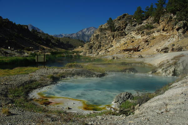
U.S. flag

An official website of the United States government

Images

California Volcano Observatory images.

Filter Total Items: 169
A red scoria cone is dotted with pine forest and sits on the valley floor near low hills of bright white Sierra Nevada granite.
Groundhog scoria cone in the Golden Trout Creek volcanic field, California

Groundhog scoria cone, the youngest of the Golden Trout Creek volcanic field, and the source of a lava flow that traveled 6 km to the west down Golden Trout Creek. The cone erupted through light-colored Mesozoic granitic rocks of the Sierra Nevada batholith visible in the distance. Photo by Rick Howard, 2002 (courtesy of Del Hubbs, U.S. Forest Service).

Groundhog scoria cone, the youngest of the Golden Trout Creek volcanic field, and the source of a lava flow that traveled 6 km to the west down Golden Trout Creek. The cone erupted through light-colored Mesozoic granitic rocks of the Sierra Nevada batholith visible in the distance. Photo by Rick Howard, 2002 (courtesy of Del Hubbs, U.S. Forest Service).

Graphic depicting the distribution of Yellowstone ash across the U....
Map of volcanic ash fall as a result of eruptions from Yellowstone,...

Map of volcanic ashfall. Areas of the United States that once were covered by volcanic ash from Yellowstone's giant eruptions 2 million and 630,000 years ago, compared with ashfall from the 760,000-year-old Long Valley caldera eruptions at Mammoth Lakes, California, and the 1980 eruption of Mount St. Helens, Washington.

Map of volcanic ashfall. Areas of the United States that once were covered by volcanic ash from Yellowstone's giant eruptions 2 million and 630,000 years ago, compared with ashfall from the 760,000-year-old Long Valley caldera eruptions at Mammoth Lakes, California, and the 1980 eruption of Mount St. Helens, Washington.

Animated GIF of the tectonic evolution of western North America shows the birth and lengthening of the San Andreas fault
Tectonic slab window

This animation of the tectonic evolution of western North America shows the birth and lengthening of the San Andreas fault as the triple junction moves north over the past 40 million years. Over time, the Farallon plate is consumed by subduction beneath North America and the divergent boundary (a.k.a.

This animation of the tectonic evolution of western North America shows the birth and lengthening of the San Andreas fault as the triple junction moves north over the past 40 million years. Over time, the Farallon plate is consumed by subduction beneath North America and the divergent boundary (a.k.a.

View of the Mono Lake-Long Valley volcanic region

An aerial view looking south of the Long Valley volcanic region in the area of Mono Lake, showing a line of rhyolite lava domes and explosion craters. An inset map shows the locations of silcic magmatic centers in the Long Valley area.

An aerial view looking south of the Long Valley volcanic region in the area of Mono Lake, showing a line of rhyolite lava domes and explosion craters. An inset map shows the locations of silcic magmatic centers in the Long Valley area.

Image: Coso Volcanic Field Tumulus
Coso Volcanic Field Tumulus

A tumulus in the Coso Volcanic Field, California. This lava was probably more viscous than the lava found in the Hawaii tumuli.

A tumulus in the Coso Volcanic Field, California. This lava was probably more viscous than the lava found in the Hawaii tumuli.

Mount Konocti, a 1,312 m (4,305 ft) mountain on the eastern shore o...

Mt. Konocti erupted during the most recent stage of volcanism (01. Ma to 10,000 years ago), and a future eruption from the same site would be devastating to the nearby inhabitants.

Mount Konocti on the western shore of Clear Lake, California

Mount Konocti, a mostly dacitic composite cone, on the western shore of Clear Lake, California. Thurston Lake is in the foreground.

In a black-and-white photo, a small wooden cabin with a peaked roof and single door and window sits in a snowy forest clearing. Snow is piled to chest height around the building and blobs of snow cling to the peak of the roof.
Lassen Volcano Observatory, 1926

The original Lassen Volcano Observatory building, provided by the US Forest Service, about 1926. The observatory consisted of a small office over a 10x10 ft concrete cellar which housed two custom-built seismographs. A small cottage nearby housed Ruy H. Finch, the head of and sole scientist at the Observatory for much of its existence. (Photo by R.H.

The original Lassen Volcano Observatory building, provided by the US Forest Service, about 1926. The observatory consisted of a small office over a 10x10 ft concrete cellar which housed two custom-built seismographs. A small cottage nearby housed Ruy H. Finch, the head of and sole scientist at the Observatory for much of its existence. (Photo by R.H.

A black-and-white photo of a man in a black suit jacket, pinstriped pants, and a dapper fedora. He is standing on a Hawaiian pahoehoe lava flow and peering into a deep ground crack.
Ruy H. Finch (1890-1957)

The founder of the Lassen Volcano Observatory (1926-1935) and second Director of the Hawaiian Volcano Observatory (1940-1951), Ruy Herbert Finch conducted research in both Hawaii and throughout the Western United States.

The founder of the Lassen Volcano Observatory (1926-1935) and second Director of the Hawaiian Volcano Observatory (1940-1951), Ruy Herbert Finch conducted research in both Hawaii and throughout the Western United States.

In this black-and-white photos, a view up a valley shows a bare moonscape of mud, silt, and boulders. In the far distance, a mountain peak rises above lines of pine trees lining the valley's sides.
Mudflows in Lost Creek, Lassen, May 22 1915

Benjamin F. Loomis Historical Photograph Collection: Lost Creek drainage area covered in mud, rocks, and debris from a mudflow off Lassen Peak. Photo courtesy of NPS.

Benjamin F. Loomis Historical Photograph Collection: Lost Creek drainage area covered in mud, rocks, and debris from a mudflow off Lassen Peak. Photo courtesy of NPS.

A black and white photograph looks across a swath cut through a pine forest by a debris and mud flow that originates at a steaming volcanic peak in the distance. A large crater is visible on the side of the volcano, which is emitting the steam. The rest of the volcano is heavily blanketed in snow.
Benjamin Loomis photograph of Lassen Peak and the Devastated Area, May 22, 1915

Steam issuing from summit of Lassen Peak from head of Lost Creek following mudflow. "Hot Rock"(large boulder) in foreground. Photographs taken a few hours prior to second major eruption and hot blast.

In a black-and-white photo, a snow-covered mountain peak is streaked with dark mud flowing down its sides in three directions. One flow directly faces the viewer, showing where trees have been mowed over by the debris. Elsewhere on the slopes, pine trees are scattered through the snow.
Lava and mudflows from Lassen Peak, May 22, 1915

Benjamin F. Loomis Historical Photograph Collection: Lassen Peak showing new lava flow on summit and large mudflows on slopes. Photo courtesy of NPS.

Benjamin F. Loomis Historical Photograph Collection: Lassen Peak showing new lava flow on summit and large mudflows on slopes. Photo courtesy of NPS.

A black and white photograph looks across a swath cut through a pine forest by a debris and mud flow that originates at a steaming volcanic peak in the distance. A large crater is visible on the side of the volcano, which is emitting the steam. The rest of the volcano is heavily blanketed in snow.
Historical photograph of Lassen Peak by Benjamin Loomis, May 22, 1915

A second view of Lassen Peak and the Deveastated Area following an explosive eruption and mudflowk. The crater of the volcano is visible, revealing that a lava dome which had previously been growing there was destroyed by the explosion. Subsequently, a lava flow began refilling the crater, and was mistakenly thought to have created the mudflow. 

A second view of Lassen Peak and the Deveastated Area following an explosive eruption and mudflowk. The crater of the volcano is visible, revealing that a lava dome which had previously been growing there was destroyed by the explosion. Subsequently, a lava flow began refilling the crater, and was mistakenly thought to have created the mudflow. 

A black-and-white stereograph photo pair shows a horse-drawn cart advancing toward the photographer on a muddy dirt road. In the middle ground, an early-20th century hotel is flanked by other small shops and a single telegraph pole. In the background, a double-peaked snow clad mountain rises high above the town, faded with distance.
Stereograph photo of Mount Shasta and the town of Sisson in 1906

Horse-drawn carriage on road in Sisson, California, El Monte Hotel in foreground, Mount Shasta in the background. Image courtesy of the Library of Congress.

Photograph of the town of Sisson (later (1922) the town of Mt. Shasta) in the distance at the foot of Mount Shasta in winter. Snow covered fir trees in the foreground.
Town of Sisson at the foot of Mount Shasta in winter, ca.1900

Photograph of the town of Sisson (later (1922) the town of Mt. Shasta) in the distance at the foot of Mount Shasta in winter. Snow covered fir trees in the foreground. Photo courtesy of University of Southern California Libraries and California Historical Society. Digitally reproduced by the USC Digital Library.

Photograph of the town of Sisson (later (1922) the town of Mt. Shasta) in the distance at the foot of Mount Shasta in winter. Snow covered fir trees in the foreground. Photo courtesy of University of Southern California Libraries and California Historical Society. Digitally reproduced by the USC Digital Library.

USGS Director Jim Reilly being given a tour of the CalVO Ops room by Emily Montgomery-Brown
USGS Director Jim Reilly being given a tour of the CalVO

In a February 5, 2019 visit, USGS Director Jim Reilly was given a tour of CalVO facilities, including the Operations Room. Here Emily Montgomery-Brown explains the networks that monitor California's threatening volcanoes.

In a February 5, 2019 visit, USGS Director Jim Reilly was given a tour of CalVO facilities, including the Operations Room. Here Emily Montgomery-Brown explains the networks that monitor California's threatening volcanoes.

Was this page helpful?