I Am A...Climate Modeler coloring page.
By

Official websites use .gov
A .gov website belongs to an official government organization in the United States.
Secure .gov websites use HTTPS
A lock () or https:// means you’ve safely connected to the .gov website. Share sensitive information only on official, secure websites.
Access all multimedia to include images, video, audio, webcams, before-after imagery, and more. Filter and explore with filtering options to refine search.

I Am A...Climate Modeler coloring page.
I Am A...Climate Modeler coloring page.

A broad overview of landslide geology across Pennsylvania, and historical and current work on landslides by the Pennsylvania Survey and others. The diverse geology and topography of Pennsylvania's woods provides a variety of landslide problems beyond the well-known issues around Pittsburgh.
A broad overview of landslide geology across Pennsylvania, and historical and current work on landslides by the Pennsylvania Survey and others. The diverse geology and topography of Pennsylvania's woods provides a variety of landslide problems beyond the well-known issues around Pittsburgh.

A prolonged dry spell has sparked woes over water availability and wildfire in the western United States.
A prolonged dry spell has sparked woes over water availability and wildfire in the western United States.

Spatter ramparts from the April 30, 1982, Kīlauea summit eruption remain visible on the floor of Kīlauea caldera. During this brief eruption, which lasted approximately 19 hours, lava erupted from a 1-km-long (0.6 mile) fissure that extended to the northeast of Halema‘uma‘u.
Spatter ramparts from the April 30, 1982, Kīlauea summit eruption remain visible on the floor of Kīlauea caldera. During this brief eruption, which lasted approximately 19 hours, lava erupted from a 1-km-long (0.6 mile) fissure that extended to the northeast of Halema‘uma‘u.

During the gas survey of Kīlauea caldera, HVO scientists walk transects in a grid-like pattern. As they traverse, the MultiGAS instruments that they are carrying on their backs measure the amount of carbon dioxide (CO2), sulfur dioxide (SO2), water vapor (H2O), and hydrogen sulfide (H2S).
During the gas survey of Kīlauea caldera, HVO scientists walk transects in a grid-like pattern. As they traverse, the MultiGAS instruments that they are carrying on their backs measure the amount of carbon dioxide (CO2), sulfur dioxide (SO2), water vapor (H2O), and hydrogen sulfide (H2S).

From the northwest corner of the largest down-dropped block within Kīlauea caldera, HVO scientists were able to spot the southern edge of the lava lake that was recently active, from December 2020 to May 2021. The ongoing Kīlauea caldera gas survey is being conducted with permission from Hawai‘i Volcanoes National Park.
From the northwest corner of the largest down-dropped block within Kīlauea caldera, HVO scientists were able to spot the southern edge of the lava lake that was recently active, from December 2020 to May 2021. The ongoing Kīlauea caldera gas survey is being conducted with permission from Hawai‘i Volcanoes National Park.

On Tuesday, August 10, HVO scientists traversed the west and south rims of Halema‘uma‘u, at the summit of Kīlauea, to collect photos of the inactive lava lake from many different angles. Such a collection of photos will enable the construction of a three-dimensional model of the crusted lake surface using structure-from-motion software.
On Tuesday, August 10, HVO scientists traversed the west and south rims of Halema‘uma‘u, at the summit of Kīlauea, to collect photos of the inactive lava lake from many different angles. Such a collection of photos will enable the construction of a three-dimensional model of the crusted lake surface using structure-from-motion software.
Mapping land cover in the United States in the present isn’t a simple job, but satellites like Landsat make it possible. Mapping conditions in the pre-satellite era, which the LANDFIRE program does through its Biophysical Settings (BpS) GIS data products, is a far trickier proposition.
Mapping land cover in the United States in the present isn’t a simple job, but satellites like Landsat make it possible. Mapping conditions in the pre-satellite era, which the LANDFIRE program does through its Biophysical Settings (BpS) GIS data products, is a far trickier proposition.

Photo Contest Winner | August 2021 | Where We Work
Hoosick River near Williamstown, MA sculpture
Photo Contest Winner | August 2021 | Where We Work
Hoosick River near Williamstown, MA sculpture

An anchor station in 20m water depth with a wave buoy and smart mooring attached. This instrument will deliver high-fidelity, real-time wave, water level, and wind data to scientists at the USGS St. Petersburg Coastal and Marine Science Center.
An anchor station in 20m water depth with a wave buoy and smart mooring attached. This instrument will deliver high-fidelity, real-time wave, water level, and wind data to scientists at the USGS St. Petersburg Coastal and Marine Science Center.

In recent weeks, HVO geophysicists have been undertaking a Global Positioning System (GPS) campaign across Kīlauea.
In recent weeks, HVO geophysicists have been undertaking a Global Positioning System (GPS) campaign across Kīlauea.
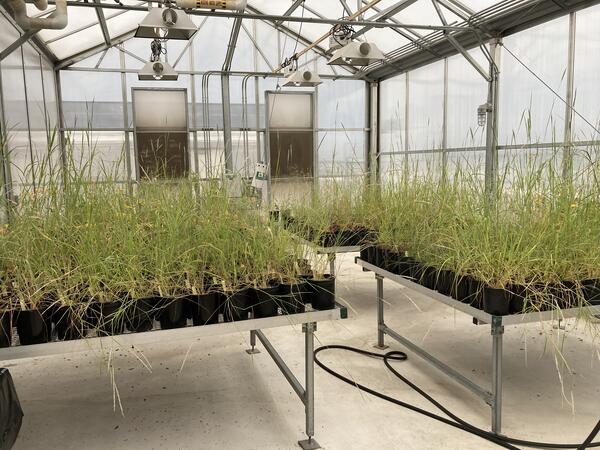
RestoreNet is partnering with the Gornish lab at the University of Arizona to better understand how a plant’s source location (provenance) influences its performance in a restoration setting. This greenhouse experiment will be conducted by PhD student, Sierra Lauman.
RestoreNet is partnering with the Gornish lab at the University of Arizona to better understand how a plant’s source location (provenance) influences its performance in a restoration setting. This greenhouse experiment will be conducted by PhD student, Sierra Lauman.

A solar-powered Sofar spotter buoy floats in the water next to the R/V (Research Vessel) Sallenger.
A solar-powered Sofar spotter buoy floats in the water next to the R/V (Research Vessel) Sallenger.

A solar-powered Sofar spotter buoy floats in the water next to the R/V (Research Vessel) Sallenger.
A solar-powered Sofar spotter buoy floats in the water next to the R/V (Research Vessel) Sallenger.

A solar-powered Sofar spotter buoy floats in the water next to the R/V (Research Vessel) Sallenger.
A solar-powered Sofar spotter buoy floats in the water next to the R/V (Research Vessel) Sallenger.

Schematic displaying the general processes associated with collapse of Yellowstone Caldera. (A) Pre-caldera volcanism includes the eruption of dome complexes from the underlying magma chambers. (B) The caldera-forming eruption evacuates a significant amount of magma from the chamber, causing the overlying crustal block to subside into the void space.&nbs
Schematic displaying the general processes associated with collapse of Yellowstone Caldera. (A) Pre-caldera volcanism includes the eruption of dome complexes from the underlying magma chambers. (B) The caldera-forming eruption evacuates a significant amount of magma from the chamber, causing the overlying crustal block to subside into the void space.&nbs

A scientific diver ascends safely towards the surface after deploying a wave buoy and smart mooring in 20m water depth. This instrument will deliver high-fidelity, real-time wave, water level, and wind data to scientists at the USGS St. Petersburg Coastal and Marine Science Center.
A scientific diver ascends safely towards the surface after deploying a wave buoy and smart mooring in 20m water depth. This instrument will deliver high-fidelity, real-time wave, water level, and wind data to scientists at the USGS St. Petersburg Coastal and Marine Science Center.

A scientific diver next to an anchor station in 20m water depth with a wave buoy and smart mooring attached. This instrument will deliver high-fidelity, real-time wave, water level, and wind data to scientists at the USGS St. Petersburg Coastal and Marine Science Center.
A scientific diver next to an anchor station in 20m water depth with a wave buoy and smart mooring attached. This instrument will deliver high-fidelity, real-time wave, water level, and wind data to scientists at the USGS St. Petersburg Coastal and Marine Science Center.

Alaska Science Center geologist Doug Kreiner and University of Alaska, Fairbanks professor Sean Regan discuss the district-scale geology with the chief exploration geologist at Pogo Mine. This is a new collaborative study with USGS, UAF and Pogo Mine, to collaborate on unraveling the genesis of Pogo, an important producer of gold in Alaska with critical mi
Alaska Science Center geologist Doug Kreiner and University of Alaska, Fairbanks professor Sean Regan discuss the district-scale geology with the chief exploration geologist at Pogo Mine. This is a new collaborative study with USGS, UAF and Pogo Mine, to collaborate on unraveling the genesis of Pogo, an important producer of gold in Alaska with critical mi

Alaska Science Center geologist Doug Kreiner and University of Alaska, Fairbanks professor Sean Regan look at igneous textures in granitic rocks hosting gold at the Pogo gold mine with Pogo exploration geologists.
Alaska Science Center geologist Doug Kreiner and University of Alaska, Fairbanks professor Sean Regan look at igneous textures in granitic rocks hosting gold at the Pogo gold mine with Pogo exploration geologists.

