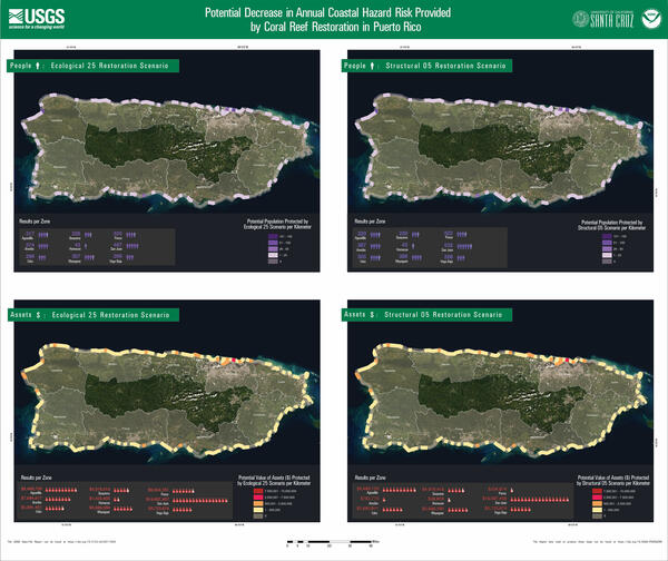
U.S. flag

An official website of the United States government

All Multimedia

Access all multimedia to include images, video, audio, webcams, before-after imagery, and more. Filter and explore with filtering options to refine search. 

Filter Total Items: 24939
Two aerial photos of Puerto Rico show colored sections along the coast to show values of loss after hurricanes.
Impact of damage by hurricanes Irma and Maria in Puerto Rico

Maps of Puerto Rico show the increase in annual coastal hazard risk due to damage by Hurricanes Irma and Maria.

  1. Increase in population at risk due to coral reef damage per kilometer (top)
  2. Increase in value ($) of assets at risk due to coral reef damage per kilometer (bottom)

Maps of Puerto Rico show the increase in annual coastal hazard risk due to damage by Hurricanes Irma and Maria.

  1. Increase in population at risk due to coral reef damage per kilometer (top)
  2. Increase in value ($) of assets at risk due to coral reef damage per kilometer (bottom)
Brochure with text and an aerial view looking down on a coast with columns depicting data values along the coast.
Social and Economic Benefits of Coral Reef Restoration in Florida, 1

Report Summary

The Social and Economic Benefits of Coral Reef Restoration in Florida

Targeted restoration of reef natural infrastructure can protect U.S. people and property from significant risk of future flooding.

Key Points

Brochure with text and an aerial view looking down on a coast with dots depicting data values along the coast.
Social and Economic Benefits of Coral Reef Restoration in Florida, 2

Coral reef restoration can yield significant flood reduction benefits. These natural defenses were damaged in the 2017 hurricanes; their recovery would reduce the risks of further storm damages to nature, people and property.

Brochure with text and a aerial view looking down on a coast with dots depicting data values along the coast.
Social and economic benefits of coral reef restoration: Puerto Rico 2

Coral reef restoration can yield significant flood reduction benefits. These natural defenses were damaged in the 2017 hurricanes; their recovery would reduce the risks of further storm damages to nature, people and property.

Coral reef restoration can yield significant flood reduction benefits. These natural defenses were damaged in the 2017 hurricanes; their recovery would reduce the risks of further storm damages to nature, people and property.

Continuous water quality station on the Mystic River at the Mystic Seaport, Mystic CT
Continuous water quality station

Continuous water quality station on the Mystic River at the Mystic Seaport, Mystic Connecticut (Site ID 412141071580200). Setup includes top and bottom multiparameter sondes and velocity uplooker.

Continuous water quality station on the Mystic River at the Mystic Seaport, Mystic Connecticut (Site ID 412141071580200). Setup includes top and bottom multiparameter sondes and velocity uplooker.

Image of the Week - Dixie Fire Ravages Northern California

The Dixie Fire has become the largest single fire in California's recorded history. State fire officials don't list it at the top, however. The record is held by the massive August Complex fire of 2020 which burned over one million acres. The term "complex" is used when multiple fires in the same area ignite separately.

The Dixie Fire has become the largest single fire in California's recorded history. State fire officials don't list it at the top, however. The record is held by the massive August Complex fire of 2020 which burned over one million acres. The term "complex" is used when multiple fires in the same area ignite separately.

Widespread landslides during the 2018 wet year in Pittsburgh

The record 2018 wet year in Pittsburgh resulted in widespread landslides throughout the region, many of which caused considerable damage to residential property and transportation infrastructure.

The record 2018 wet year in Pittsburgh resulted in widespread landslides throughout the region, many of which caused considerable damage to residential property and transportation infrastructure.

Photo of Pack Creek at Pack Creek Road Bridge river gage looking downstream Pack Creek in Utah
Pack Creek at Pack Creek Road Bridge river gage

Photo looking downstream from the Pack Creek Road Bridge shows the rain gage on top with a USGS sticker. Below is a solar panel for power. The other white round object contains the data logger and satellite antenna.

Photo looking downstream from the Pack Creek Road Bridge shows the rain gage on top with a USGS sticker. Below is a solar panel for power. The other white round object contains the data logger and satellite antenna.

man knee deep in a body of water next to a USGS boat holding a wire with green grass and trees in the background
Resistivity surveys in Northern Minnesota

USGS New York Water Science Center Research Hyrologist Neil Terry preparing for resistivity surveys in Northern Minnesota. (Credit: Josh Woda, USGS NY WSC, Public domain.)

USGS New York Water Science Center Research Hyrologist Neil Terry preparing for resistivity surveys in Northern Minnesota. (Credit: Josh Woda, USGS NY WSC, Public domain.)

Outstanding in the Field - Episode 8 artwork
USGS Outstanding in the Field, Episode 8, Braving thin ice
Outstanding in the Field - Episode 8 artwork
USGS Outstanding in the Field, Episode 8, Braving thin ice

This is the first in a special edition of Outstanding in the Field, the U.S. Geological Survey’s podcast series produced by the Ecosystems Mission Area. In this series we will be highlighting stories from the Alaska Voices podcast, a partnership between the U.S. Geological Survey’s Alaska Climate Adaptation Science Center and the University of Alaska Fairbanks.

This is the first in a special edition of Outstanding in the Field, the U.S. Geological Survey’s podcast series produced by the Ecosystems Mission Area. In this series we will be highlighting stories from the Alaska Voices podcast, a partnership between the U.S. Geological Survey’s Alaska Climate Adaptation Science Center and the University of Alaska Fairbanks.

Infographic on the 2011 Virginia Earthquake and East Coast Earthquake Hazards
2011 Virginia Earthquake - Infographic

USGS infographic on the magnitude 5.8 earthquake that struck central Virginia August 23, 2011, east coast earthquake hazards and how the USGS is helping inform critical decisions to protect lives and property. 

Full Text Description:

10-YEAR ANNIVERSARY OF THE M5.8 EARTHQUAKE IN VIRGINIA
America’s Most Widely Felt Earthquake

Earth As Art 3
Earth As Art 3
Earth As Art 3

The Earth As Art project began in the early 2000s, and its original intent remains the same: to produce images that do not look like satellite images at first glance.

The Earth As Art project began in the early 2000s, and its original intent remains the same: to produce images that do not look like satellite images at first glance.

Earth As Art 4
Earth As Art 4
Earth As Art 4

The Earth As Art project began in the early 2000s, and its original intent remains the same: to produce images that do not look like satellite images at first glance.

The Earth As Art project began in the early 2000s, and its original intent remains the same: to produce images that do not look like satellite images at first glance.

On the north margin of the south sulfur bank light-colored deposits are evidence of ongoing alteration from volcanic gas
Kīlauea caldera gas mapping—August 3, 2021

On the north margin of the south sulfur bank, which was exposed during the Kīlauea summit collapse events in 2018, light-colored deposits are evidence of the ongoing alteration from volcanic gas emissions.

On the north margin of the south sulfur bank, which was exposed during the Kīlauea summit collapse events in 2018, light-colored deposits are evidence of the ongoing alteration from volcanic gas emissions.

An HVO scientist collects a carbon dioxide sample from an area within Kīlauea caldera emitting elevated levels of volcanic gas
Kīlauea caldera gas mapping—August 3, 2021

An HVO scientist uses a syringe to capture a sample from an area within Kīlauea caldera that was identified as emitting elevated levels of the volcanic gas carbon dioxide. The sample is transferred to a gas sample bag, which will later be taken to a lab for chemical analyses. USGS photo by K. Mulliken on August 3, 2021.

An HVO scientist uses a syringe to capture a sample from an area within Kīlauea caldera that was identified as emitting elevated levels of the volcanic gas carbon dioxide. The sample is transferred to a gas sample bag, which will later be taken to a lab for chemical analyses. USGS photo by K. Mulliken on August 3, 2021.

I Am A...Climate Modeler coloring page
Pennsylvania Landslides, Pittsburgh and Beyond: A 40-year Perspective

A broad overview of landslide geology across Pennsylvania, and historical and current work on landslides by the Pennsylvania Survey and others. The diverse geology and topography of Pennsylvania's woods provides a variety of landslide problems beyond the well-known issues around Pittsburgh.

A broad overview of landslide geology across Pennsylvania, and historical and current work on landslides by the Pennsylvania Survey and others. The diverse geology and topography of Pennsylvania's woods provides a variety of landslide problems beyond the well-known issues around Pittsburgh.

Was this page helpful?