Cyanobacterial bloom at Ash River Harbor near Voyageurs National Park
Cyanobacterial bloom at Ash River Harbor near Voyageurs National ParkCyanobacterial bloom at Kabetogama Lake in Voyageurs National Park

Official websites use .gov
A .gov website belongs to an official government organization in the United States.
Secure .gov websites use HTTPS
A lock () or https:// means you’ve safely connected to the .gov website. Share sensitive information only on official, secure websites.
Explore our planet through photography and imagery, including climate change and water all the way back to the 1800s when the USGS was surveying the country by horse and buggy.

Cyanobacterial bloom at Kabetogama Lake in Voyageurs National Park
Cyanobacterial bloom at Kabetogama Lake in Voyageurs National Park

Cyanobacterial bloom in Kabetogama Lake with fall leaves in the background
Cyanobacterial bloom in Kabetogama Lake with fall leaves in the background

Flooding at Vekol Wash today, south of Phoenix, following remnant rains from Hurricane Rosa.
Flooding at Vekol Wash today, south of Phoenix, following remnant rains from Hurricane Rosa.

Typed information on back of photograph: Major John Wesley Powell, a series of three photos, number 1.
Typed information on back of photograph: Major John Wesley Powell, a series of three photos, number 1.

View looking west from the Brushy Mountains, NC, to the Blue Ridge escarpment and highlands of the Blue Ridge. The high jagged peak toward the left side of the photo is Grandfather Mountain and is covered by a winter snow.
View looking west from the Brushy Mountains, NC, to the Blue Ridge escarpment and highlands of the Blue Ridge. The high jagged peak toward the left side of the photo is Grandfather Mountain and is covered by a winter snow.

Gage house for Spearfish Creek at Spearfish, SD (USGS streamgage 06431500). This site was established as a U.S. Geological Survey streamgage on October 9, 1946, and is operated in cooperation with South Dakota Department of Natural Resources. Streamgages are visited by a USGS hydrologic technician on 6-week intervals throughout the year.
Gage house for Spearfish Creek at Spearfish, SD (USGS streamgage 06431500). This site was established as a U.S. Geological Survey streamgage on October 9, 1946, and is operated in cooperation with South Dakota Department of Natural Resources. Streamgages are visited by a USGS hydrologic technician on 6-week intervals throughout the year.

Staff gage for Spearfish Creek at Spearfish, SD (USGS streamgage 06431500). This site was established as a U.S. Geological Survey streamgage on October 9, 1946, and is operated in cooperation with South Dakota Department of Natural Resources.
Staff gage for Spearfish Creek at Spearfish, SD (USGS streamgage 06431500). This site was established as a U.S. Geological Survey streamgage on October 9, 1946, and is operated in cooperation with South Dakota Department of Natural Resources.
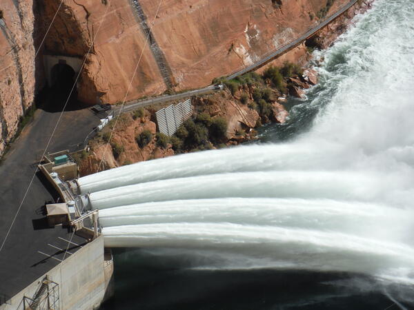
Looking down on Glen Canyon Dam jet tubes releasing water into the Colorado River for a November 2018 high flow experiment. The increase in flow of the Colorado River downstream of the dam mobilizes sand at the bottom of the river and that sand rebuilds sandbars in Grand Canyon.
Looking down on Glen Canyon Dam jet tubes releasing water into the Colorado River for a November 2018 high flow experiment. The increase in flow of the Colorado River downstream of the dam mobilizes sand at the bottom of the river and that sand rebuilds sandbars in Grand Canyon.

Glen Canyon Dam jet tubes releasing water into the Colorado River for a November 2018 high flow experiment. The increase in flow of the Colorado River downstream of the dam mobilizes sand at the bottom of the river and that sand rebuilds sandbars in Grand Canyon.
Glen Canyon Dam jet tubes releasing water into the Colorado River for a November 2018 high flow experiment. The increase in flow of the Colorado River downstream of the dam mobilizes sand at the bottom of the river and that sand rebuilds sandbars in Grand Canyon.

Shown in this photo is Hydrologic Technician Sam Banas performing an electric tape down measurement of a groundwater well. The site ID is: 422906072124301 MA-PHW 16 Petersham, MA
Shown in this photo is Hydrologic Technician Sam Banas performing an electric tape down measurement of a groundwater well. The site ID is: 422906072124301 MA-PHW 16 Petersham, MA

View from bridge of USGS gage 07241800, North Canadian River at Shawnee, OK
View from bridge of USGS gage 07241800, North Canadian River at Shawnee, OK

Satellite image of Taku Glacier in October 1, 2018. The Norris Glacier can be seen on the lower left hand corner and the Hole-in-the-Wall Glacier in the upper center portion of the image.
Satellite image of Taku Glacier in October 1, 2018. The Norris Glacier can be seen on the lower left hand corner and the Hole-in-the-Wall Glacier in the upper center portion of the image.

Satellite image of Taku Glacier in October 1, 2018. The Norris Glacier can be seen on the lower left hand corner and the Hole-in-the-Wall Glacier in the upper center portion of the image. Citation: McNeil, C. J., and Baker, E.
Satellite image of Taku Glacier in October 1, 2018. The Norris Glacier can be seen on the lower left hand corner and the Hole-in-the-Wall Glacier in the upper center portion of the image. Citation: McNeil, C. J., and Baker, E.

View of a clear blue hot spring pool of alkaline chloride fluid with silica sinter apron around it at Biscuit Basin. This pool is generally close to the boiling temperature (200℉, 93℃) at this altitude (7200 ft, 2195 m).
View of a clear blue hot spring pool of alkaline chloride fluid with silica sinter apron around it at Biscuit Basin. This pool is generally close to the boiling temperature (200℉, 93℃) at this altitude (7200 ft, 2195 m).

Alkaline-chloride waters from an eruption of Old Faithful flow over the edge of the white silica sinter terrace into the Firehole River. The orange coloration on the sinter terrace is due to thermophilic (high temperature) bacteria living in the warm fluids. Old Faithful Inn is in the background, with the wooded Summit Lake rhyolitic lava flow behind.&nb
Alkaline-chloride waters from an eruption of Old Faithful flow over the edge of the white silica sinter terrace into the Firehole River. The orange coloration on the sinter terrace is due to thermophilic (high temperature) bacteria living in the warm fluids. Old Faithful Inn is in the background, with the wooded Summit Lake rhyolitic lava flow behind.&nb

Remote Camera, 30-mile Camp (River MIe 30.7)

The Maumee River Watershed with Areas of Concern
The Maumee River Watershed with Areas of Concern

A larval sampling boat with nets prepared for deployment
A larval sampling boat with nets prepared for deployment

Cross section wading measurement looking downstream at Bull Lake Creek above Bull Lake.
Cross section wading measurement looking downstream at Bull Lake Creek above Bull Lake.

Only small amounts of sulfur dioxide (SO2) and hydrogen sulfide (H2S) are currently being released from Kīlauea, but they chemically react with each other (oxidation-reduction reaction) to form the bright yellow sulfur deposits visible on the crater walls within Halema‘uma‘u.
Only small amounts of sulfur dioxide (SO2) and hydrogen sulfide (H2S) are currently being released from Kīlauea, but they chemically react with each other (oxidation-reduction reaction) to form the bright yellow sulfur deposits visible on the crater walls within Halema‘uma‘u.

USGS Hydrologist Irene Fisher monitors groundwater conditions at an agricultural well.
USGS Hydrologist Irene Fisher monitors groundwater conditions at an agricultural well.