
This photo was taken within Yellowstone National Park and shows a cableway view of Lamar River near Tower Ranger Station. Less than half a mile downstream, the Lamar River flows into the more well-known Yellowstone River. When this photo was taken, flows were just a bit above average at the streamgage.
Images
Explore our planet through photography and imagery, including climate change and water all the way back to the 1800s when the USGS was surveying the country by horse and buggy.
Filter Total Items: 21343

Lamar River Downstream View
This photo was taken within Yellowstone National Park and shows a cableway view of Lamar River near Tower Ranger Station. Less than half a mile downstream, the Lamar River flows into the more well-known Yellowstone River. When this photo was taken, flows were just a bit above average at the streamgage.

Nested polymerase chain reaction (nPCR) for the detection of Rs
Nested polymerase chain reaction (nPCR) for the detection of RsNested polymerase chain reaction (nPCR) for the detection of Renibacterium salmoninarum. Agarose gel electrophoresis is used for size separation and visualization of amplified DNA sequences.

Ocean entry plume rising from just offshore of Ahalanui Beach Park
Ocean entry plume rising from just offshore of Ahalanui Beach Park
School Branch at Maloney Road near Brownsburg IN - debris on stream
School Branch at Maloney Road near Brownsburg IN - debris on streamSchool Branch at Maloney Road near Brownsburg IN - debris on stream
School Branch at Maloney Road near Brownsburg IN - debris on stream
School Branch at Maloney Road near Brownsburg IN - debris on streamSchool Branch at Maloney Road near Brownsburg IN - debris on stream

School Branch at Maloney Road near Brownsburg IN - large debris pile
School Branch at Maloney Road near Brownsburg IN - large debris pileSchool Branch at Maloney Road near Brownsburg IN - large debris pile
School Branch at Maloney Road near Brownsburg IN - large debris pile
School Branch at Maloney Road near Brownsburg IN - large debris pileSchool Branch at Maloney Road near Brownsburg IN - large debris pile

School Branch at Maloney Road near Brownsburg IN - stagnant water
School Branch at Maloney Road near Brownsburg IN - stagnant waterSchool Branch at Maloney Road near Brownsburg IN - stagnant water
School Branch at Maloney Road near Brownsburg IN - stagnant water
School Branch at Maloney Road near Brownsburg IN - stagnant waterSchool Branch at Maloney Road near Brownsburg IN - stagnant water

School Branch at Maloney Road near Brownsburg IN - stagnant water
School Branch at Maloney Road near Brownsburg IN - stagnant waterSchool Branch at Maloney Road near Brownsburg IN - muddy stream
School Branch at Maloney Road near Brownsburg IN - stagnant water
School Branch at Maloney Road near Brownsburg IN - stagnant waterSchool Branch at Maloney Road near Brownsburg IN - muddy stream

School Branch at Maloney Road near Brownsburg IN - stagnant water
School Branch at Maloney Road near Brownsburg IN - stagnant waterSchool Branch at Maloney Road near Brownsburg IN - low flowing stream
School Branch at Maloney Road near Brownsburg IN - stagnant water
School Branch at Maloney Road near Brownsburg IN - stagnant waterSchool Branch at Maloney Road near Brownsburg IN - low flowing stream

Blacks Fork above Smiths Fork Streamgage
Blacks Fork above Smiths Fork Streamgage

Dropping the Wire Weight
The wire weight was dropped from this bridge to measure the stream stage of the Blacks Fork River near Lyman, Wyoming. Even with an early start, it is a struggle to get work done before an afternoon storm rolls in.
The wire weight was dropped from this bridge to measure the stream stage of the Blacks Fork River near Lyman, Wyoming. Even with an early start, it is a struggle to get work done before an afternoon storm rolls in.

Kīlauea lower East Rift Zone
Taken from the July 31 morning overflight, this photo shows the west side of the fissure 8 lava channel with Kapoho Crater in the foreground. Fissure 8 and its gas plume are visible in the distance.
Taken from the July 31 morning overflight, this photo shows the west side of the fissure 8 lava channel with Kapoho Crater in the foreground. Fissure 8 and its gas plume are visible in the distance.

Kīlauea lower East Rift Zone lava flow
During an overflight this morning, the Hawaii County Fire Department captured this image looking east toward Kapoho Crater.
During an overflight this morning, the Hawaii County Fire Department captured this image looking east toward Kapoho Crater.
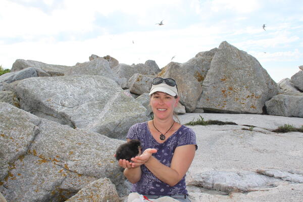
Atlantic puffin chick
Staudinger holding a Atlantic puffin chick on Seal Island National Wildlife Refuge.
Staudinger holding a Atlantic puffin chick on Seal Island National Wildlife Refuge.

Kīlauea summit
This aerial view of Kīlauea's summit (taken early yesterday morning, looking south) shows some well-known features and some that are now more obvious as a result of ongoing collapse of Halema‘uma‘u and parts of the summit caldera floor.
This aerial view of Kīlauea's summit (taken early yesterday morning, looking south) shows some well-known features and some that are now more obvious as a result of ongoing collapse of Halema‘uma‘u and parts of the summit caldera floor.

Kīlauea Volcano — Aerial View of Kapoho Crater
Aerial view of Kapoho Crater looking toward the south-southeast. Part of the lava channelbecame blocked just upstream of Kapoho Crater yesterday, diverting flows to the west and then south around the crater (center right). Lava exiting a crusted section of the channel continued flowing in the channel pathway (lower center to left).
Aerial view of Kapoho Crater looking toward the south-southeast. Part of the lava channelbecame blocked just upstream of Kapoho Crater yesterday, diverting flows to the west and then south around the crater (center right). Lava exiting a crusted section of the channel continued flowing in the channel pathway (lower center to left).

Kīlauea Volcano — Fissure 8 and Lava Channel
Fissure 8 and a full lava channel as seen during HVO's early morning overflight. The visible road is Nohea Street in the Leilani Estates subdivision.
Fissure 8 and a full lava channel as seen during HVO's early morning overflight. The visible road is Nohea Street in the Leilani Estates subdivision.

Kīlauea Volcano — Landscape Differences
During HVO's morning overflight today, the dramatic difference in landscapes on the northern and southern sides of the fissure 8 lava channel was readily apparent.
During HVO's morning overflight today, the dramatic difference in landscapes on the northern and southern sides of the fissure 8 lava channel was readily apparent.

Kīlauea Volcano — Looking Uprift Past Halekamahina
Kīlauea Volcano — Looking Uprift Past Halekamahina
Deadly Mudslides in Japan
Torrential rainfall swamped western Japan in July of 2018. The rain caused mudslides that flooded cities, damaged buildings and rattled the nation’s infrastructure.
Torrential rainfall swamped western Japan in July of 2018. The rain caused mudslides that flooded cities, damaged buildings and rattled the nation’s infrastructure.

Core retrieval
Dr. Meagan Gonneea (Cape Cod, MA) retrieves a core from an infilling salt marsh pond in the Great Barnstable Marsh.
Dr. Meagan Gonneea (Cape Cod, MA) retrieves a core from an infilling salt marsh pond in the Great Barnstable Marsh.

Kīlauea Volcano — Fissure 8 and Leilani Estates
Fissure 8 and Leilani Estates viewed from the south. Houses in the foreground are located in the southern portion of Leilani Estates.
Fissure 8 and Leilani Estates viewed from the south. Houses in the foreground are located in the southern portion of Leilani Estates.