
The fissure 8 lava fountain pulses to heights of 50 m (165 ft) within a cinder spatter cone. Fissure 8 feeds&nbs
Images
Explore our planet through photography and imagery, including climate change and water all the way back to the 1800s when the USGS was surveying the country by horse and buggy.
Filter Total Items: 21343

Kīlauea Volcano — Lava Fountain
The fissure 8 lava fountain pulses to heights of 50 m (165 ft) within a cinder spatter cone. Fissure 8 feeds&nbs

Kīlauea Volcano — Vacationland Laze Plume
Lava enters the ocean entry in the vicinity of Vacationland, producing a vigorous laze plume. Lava flowing into the ocean has built a delta of flows, rock rubble and black sand, which is over 320 acres in size.
Lava enters the ocean entry in the vicinity of Vacationland, producing a vigorous laze plume. Lava flowing into the ocean has built a delta of flows, rock rubble and black sand, which is over 320 acres in size.

Kīlauea's LERZ
Morning overflight of Kīlauea Volcano's lower East Rift Zone by the Civil Air Patrol provides context for the location of the fissure 8 fountain and lava channel within the lower Puna District. View is to the north. Image courtesy of Civil Air Patrol.
Morning overflight of Kīlauea Volcano's lower East Rift Zone by the Civil Air Patrol provides context for the location of the fissure 8 fountain and lava channel within the lower Puna District. View is to the north. Image courtesy of Civil Air Patrol.

WERC's Dr. Phil van Mantgem Extracts Core from Ponderosa Pine
WERC's Dr. Phil van Mantgem Extracts Core from Ponderosa PineDr. Phillip van Mantgem extracts a core sample from a ponderosa pine (Pinus ponderosa) that has experienced
prescribed fire in Lassen National Park, CA.
WERC's Dr. Phil van Mantgem Extracts Core from Ponderosa Pine
WERC's Dr. Phil van Mantgem Extracts Core from Ponderosa PineDr. Phillip van Mantgem extracts a core sample from a ponderosa pine (Pinus ponderosa) that has experienced
prescribed fire in Lassen National Park, CA.

Fissure activity and active ocean entry in Kīlauea's LERZ
Fissure activity and active ocean entry in Kīlauea's LERZFissure 8 produces a lava fountain that pulses to heights of 55 to 60 m (185 to 200 ft). Spattering has built a cinder cone that partially encircles fissure 8, now 51 m (170 ft) tall at its highest point. The steam in the foreground is the result of heavy morning rain falling on warm (not hot) tephra (lava fragments).

Kīlauea Volcano — Halema`uma`u Slumping
At Kīlauea Volcano's summit, inward slumping of the rim and walls of Halema‘uma‘u continues in response to ongoing subsidence. In this view to the southwest taken after this morning's event, a section of dark-colored wall rock (center left) has detached and dropped downward into the crater.
At Kīlauea Volcano's summit, inward slumping of the rim and walls of Halema‘uma‘u continues in response to ongoing subsidence. In this view to the southwest taken after this morning's event, a section of dark-colored wall rock (center left) has detached and dropped downward into the crater.

Kīlauea Volcano — Kapoho Bay and Vacationland
Lava from fissure 8 travels about 13 km (8 mi) down a well established channel (visible in the center of the image) to an ocean entry at Kapoho. Lava is building a seaward delta that is approximately 320 acres in size. The view is to the southwest with the Kapoho area in the lower right.
Lava from fissure 8 travels about 13 km (8 mi) down a well established channel (visible in the center of the image) to an ocean entry at Kapoho. Lava is building a seaward delta that is approximately 320 acres in size. The view is to the southwest with the Kapoho area in the lower right.

Kīlauea Volcano — Vacationland Ocean Entry
View of the active ocean entry in the vicinity of Vacationland. The interaction of hot lava with the ocean creates "laze", a corrosive seawater plume laden with hydrochloric acid and fine volcanic particles that can irritate the skin, eyes, and lungs, but that dissipates quickly with distance.
View of the active ocean entry in the vicinity of Vacationland. The interaction of hot lava with the ocean creates "laze", a corrosive seawater plume laden with hydrochloric acid and fine volcanic particles that can irritate the skin, eyes, and lungs, but that dissipates quickly with distance.

Scientist shows off a tree core fresh out of the tree
Scientist shows off a tree core fresh out of the treeScientists use a tool called an increment borer to remove cyllindrical tree cores from living trees. The cores show the tree's rings and help scientists learn about its growth.
Scientist shows off a tree core fresh out of the tree
Scientist shows off a tree core fresh out of the treeScientists use a tool called an increment borer to remove cyllindrical tree cores from living trees. The cores show the tree's rings and help scientists learn about its growth.

WERC's Dr. Phil van Mantgem Cores Ponderosa Pine in Lassen NP
WERC's Dr. Phil van Mantgem Cores Ponderosa Pine in Lassen NPDr. Phillip van Mantgem cores a ponderosa pine (Pinus ponderosa) in Lassen National Park, CA.
WERC's Dr. Phil van Mantgem Cores Ponderosa Pine in Lassen NP
WERC's Dr. Phil van Mantgem Cores Ponderosa Pine in Lassen NPDr. Phillip van Mantgem cores a ponderosa pine (Pinus ponderosa) in Lassen National Park, CA.

Acetolysis Set-Up, Pollen Laboratory
Seen in this image is the acetolysis set up. Acetolysis is used to remove the genetic material from inside the pollen, which allows the scientists to better identify and count the pollen.
Seen in this image is the acetolysis set up. Acetolysis is used to remove the genetic material from inside the pollen, which allows the scientists to better identify and count the pollen.

Kīlauea Volcano — Fissure 8 Lava Fountain
Photograph taken during helicopter overflight captures fissure 8 lava fountain.
Photograph taken during helicopter overflight captures fissure 8 lava fountain.
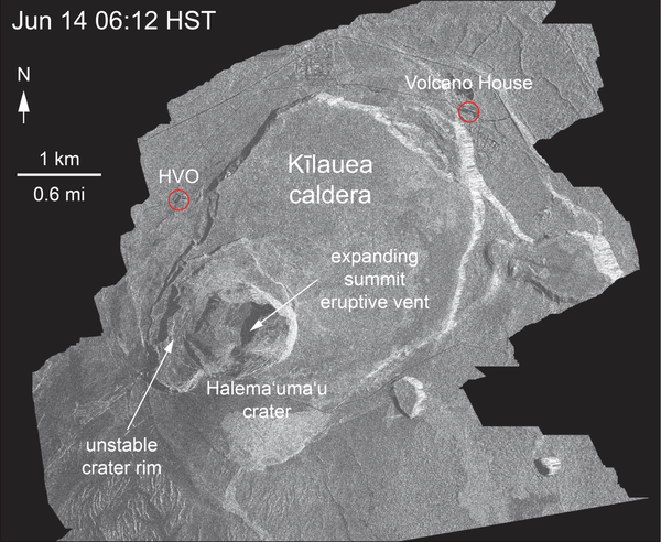
Kīlauea Volcano — Halema`uma`u Crater Enlargement
This animated GIF shows a sequence of radar amplitude images that were acquired by the Agenzia Spaziale Italiana CosmoSkyMed satellite system. The images illustrate changes to the caldera area of Kīlauea Volcano that occurred between May 5 and June 14 at about 6:00 a.m. HST.
This animated GIF shows a sequence of radar amplitude images that were acquired by the Agenzia Spaziale Italiana CosmoSkyMed satellite system. The images illustrate changes to the caldera area of Kīlauea Volcano that occurred between May 5 and June 14 at about 6:00 a.m. HST.

Kīlauea Volcano — Ocean Entry
The ocean entry remains fairly broad with a white steam/laze plume blowing onshore. USGS image taken June 15, 2018.
The ocean entry remains fairly broad with a white steam/laze plume blowing onshore. USGS image taken June 15, 2018.

Kīlauea Volcano — Spatter Cone Building
Lava fountains from Fissure 8 reach heights of 200 ft overnight. The cinder and spatter cone that is building around the fissure is now about 165 ft at its highest point.
Lava fountains from Fissure 8 reach heights of 200 ft overnight. The cinder and spatter cone that is building around the fissure is now about 165 ft at its highest point.

Pollen Under a Microscope
This image was taken through the eyepiece of a microscope. Pollen is mixed in with a few larger pieces of organic material.
This image was taken through the eyepiece of a microscope. Pollen is mixed in with a few larger pieces of organic material.

Slide of Pollen, Pollen Laboratory
A lab technician holds up the finished product after processing: an almost pure slide of pollen.
A lab technician holds up the finished product after processing: an almost pure slide of pollen.

Weighing Sediment Samples from the Great Dismal Swamp, 2018
Weighing Sediment Samples from the Great Dismal Swamp, 2018In the sample preperation room, a lab technician weighs sediments samples before placing them in a warming oven to dry.
Weighing Sediment Samples from the Great Dismal Swamp, 2018
Weighing Sediment Samples from the Great Dismal Swamp, 2018In the sample preperation room, a lab technician weighs sediments samples before placing them in a warming oven to dry.

A Tetons sunrise in Antelope Flats
A Tetons sunrise in Antelope Flats, Wyoming.
A Tetons sunrise in Antelope Flats, Wyoming.

Collecting periphyton samples, Boise River, Idaho
Hydrologist Lauren Zinsser collects a periphyton sample from the lower Boise River in southwestern Idaho
Hydrologist Lauren Zinsser collects a periphyton sample from the lower Boise River in southwestern Idaho

Driftwood on the edge of a sandy beach on Fire Island
Driftwood on the edge of a sandy beach on Fire IslandDriftwood on the edge of a sandy beach, against the background of the Fire Island breach, with the other edge of the breach in the background.
Driftwood on the edge of a sandy beach on Fire Island
Driftwood on the edge of a sandy beach on Fire IslandDriftwood on the edge of a sandy beach, against the background of the Fire Island breach, with the other edge of the breach in the background.