
Lava from fissure 8 is entering the sea this morning on the southern portion of the flow front primarily through the open channel, but also along this 1 km (0.6 mi) wide area with multiple laze plumes from smaller oozing lobes.
Images
Explore our planet through photography and imagery, including climate change and water all the way back to the 1800s when the USGS was surveying the country by horse and buggy.
Filter Total Items: 21343

Kīlauea Volcano — Laze Plumes
Lava from fissure 8 is entering the sea this morning on the southern portion of the flow front primarily through the open channel, but also along this 1 km (0.6 mi) wide area with multiple laze plumes from smaller oozing lobes.

Kīlauea Volcano — Ocean Entry
North facing view of the 1 km (0.6 mi) long ocean entry with multiple lobes of lava flowing into the sea.
North facing view of the 1 km (0.6 mi) long ocean entry with multiple lobes of lava flowing into the sea.

Kīlauea Volcano — Remobilized Ash Plume
Recent explosive events haven't produced significant ash plumes from the summit, but downwind communities may still experience ashfall when previously erupted ash is remobilized. On authorized permission from Hawai‘i Volcanoes National Park, our Unmanned Aircraft Systems crew is conducting gas measurements at Pu‘u ‘Ō‘ō.
Recent explosive events haven't produced significant ash plumes from the summit, but downwind communities may still experience ashfall when previously erupted ash is remobilized. On authorized permission from Hawai‘i Volcanoes National Park, our Unmanned Aircraft Systems crew is conducting gas measurements at Pu‘u ‘Ō‘ō.

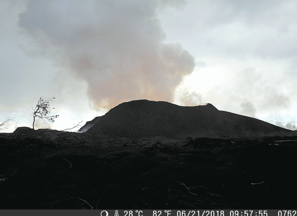
Kīlauea Volcano — Webcam Plume
At 10:41 p.m.

Like many Keys corals, this one has no new growth
A modern coral reef in Dry Tortugas National Park. There is little living coral and high rates of bioerosion. Photo taken under research permit number DRTO-2018-SCI-0005. Credit: Lauren Toth, USGS
A modern coral reef in Dry Tortugas National Park. There is little living coral and high rates of bioerosion. Photo taken under research permit number DRTO-2018-SCI-0005. Credit: Lauren Toth, USGS

Tidal marsh near San Pablo Bay
Lower Tubbs Island is a tidal marsh near Midshipman Point in northern San Pablo Bay, California, and is part of the San Pablo Bay National Wildlife Refuge. Historically, Tubbs Island was used as a club for duck hunters, protected by levees that could be opened with the tides to release salt water into the sloughs. In 1969, it was purchased by the Natu
Lower Tubbs Island is a tidal marsh near Midshipman Point in northern San Pablo Bay, California, and is part of the San Pablo Bay National Wildlife Refuge. Historically, Tubbs Island was used as a club for duck hunters, protected by levees that could be opened with the tides to release salt water into the sloughs. In 1969, it was purchased by the Natu

Backcountry Travel for Science
USGS scientists Kim Besiner, John Solder and Kate Wilkins collect groundwater samples at Grapevine Main Spring.
Scientists traveled to the remote locations along the south rim of the Grand Canyon to assess the potential effects of mining along the Coconino Plateau and groundwater withdrawals associated with increasing populations.

Backcountry Travel for Science
A group of USGS and National Park Service scientists above Granite Gorge on route for 56 miles and 20,000 vertical feet along the south rim of the Grand Canyon to collect groundwater samples from three springs.
Scientists in this photo (left to right) are Christina Bryant, Kim Beisner, John Solder and Kate Wilkins.

Backcountry travel in Grand Canyon to collect groundwater samples
Backcountry travel in Grand Canyon to collect groundwater samplesUSGS scientist Nick Voichick rafted about 150 miles in nine days on the Grand Canyon portion of the Colorado River to collect groundwater samples from springs in remote locations.

Backcountry travel in Grand Canyon to collect groundwater samples
Backcountry travel in Grand Canyon to collect groundwater samplesUSGS scientists Tom Porter and Joel Unema warm up in the sun as the scientific expedition moves downstream to the next sample location.
Backcountry travel in Grand Canyon to collect groundwater samples
Backcountry travel in Grand Canyon to collect groundwater samplesUSGS scientists Tom Porter and Joel Unema warm up in the sun as the scientific expedition moves downstream to the next sample location.

Backcountry travel in Grand Canyon to collect groundwater samples
Backcountry travel in Grand Canyon to collect groundwater samplesUSGS scientist Joel Unema hikes to National Canyon Spring to collect groundwater samples from a remote location near the south rim of the Grand Canyon. Joel Unema was part of a group of USGS and National Park Service scientists that rafted 150 miles in nine days to better understand natural resources.

Collecting Water-Quality Sample Using Bridge Crane, Bighorn River
Collecting Water-Quality Sample Using Bridge Crane, Bighorn RiverSummer Interns learning about sampling at the Bighorn River near Worland, Wyoming. The team used the bridge crane and heavy sampler to get water while streamflow was about twice average for the date.

Kīlauea Volcano — Documenting Fissure 8 Activity
USGS Hawaiian Volcano Observatory geology field crews maintain watch over the eruptive activity in the lower East Rift Zone and at Kīlauea's summit. Here, a geologist documents the behavior of lava as it exits the Fissure 8 cone. Lava enters the upper channel traveling as fast as 30 km/hour (18 mi/hour).
USGS Hawaiian Volcano Observatory geology field crews maintain watch over the eruptive activity in the lower East Rift Zone and at Kīlauea's summit. Here, a geologist documents the behavior of lava as it exits the Fissure 8 cone. Lava enters the upper channel traveling as fast as 30 km/hour (18 mi/hour).
Kīlauea Volcano — Fissure 8 Cone Changes (GIF)

Kīlauea Volcano — Fissure 8 From Luana Street
View of the fissure 8 cone and fountain from the end of Luana Street in Leilani Estates. Photo taken at 12:20 p.m.
View of the fissure 8 cone and fountain from the end of Luana Street in Leilani Estates. Photo taken at 12:20 p.m.

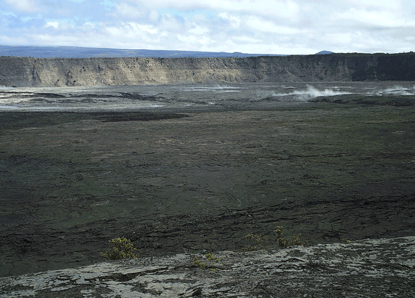
Kīlauea Volcano — Halema`uma`u Panoramic
This panorama of Kīlauea's summit caldera was made about 10 a.m. HST from the Keanakāko‘i overlook on the south side of the caldera. Halema‘uma‘u is visible steaming to the left, and the ongoing ground cracking is visible in the center of the image.
This panorama of Kīlauea's summit caldera was made about 10 a.m. HST from the Keanakāko‘i overlook on the south side of the caldera. Halema‘uma‘u is visible steaming to the left, and the ongoing ground cracking is visible in the center of the image.

Kīlauea Volcano — Sunrise Over Lava Channel
Early morning view of the open lava channel during helicopter overflight of the lower East Rift Zone.
Early morning view of the open lava channel during helicopter overflight of the lower East Rift Zone.

Woods Hole's Aerial Imaging and Mapping pilots in Hawaii
Woods Hole's Aerial Imaging and Mapping pilots in HawaiiWoods Hole Coastal and Marine Science Center's Aerial Imaging and Mapping rock stars preparing to fly Unmanned Aerial Systems (UAS) mission while a river of lava flows in the background
Woods Hole's Aerial Imaging and Mapping pilots in Hawaii
Woods Hole's Aerial Imaging and Mapping pilots in HawaiiWoods Hole Coastal and Marine Science Center's Aerial Imaging and Mapping rock stars preparing to fly Unmanned Aerial Systems (UAS) mission while a river of lava flows in the background

Kīlauea summit subsides and produces frequent earthquakes
Kīlauea summit subsides and produces frequent earthquakesOn June 23, 2018 at 4:32 p.m. HST after approximately 17 hours of elevated seismicity, a collapse explosion occurred at the summit if Kīlauea. The energy released by the event was equivalent to a magnitude 5.3 earthquake.
Kīlauea Volcano — Animated GIF of Crater Subsidence
Kīlauea Volcano — Animated GIF of Crater SubsidenceThis animated GIF shows a timelapse sequence consisting of one image per day between June 13 and 24. The photos were taken from the southern caldera rim, near Keanakāko‘i Crater, and look north towards HVO and Jaggar Museum.

Kīlauea Volcano — Fissure 8 Fountain
At fissure 8, fountains provide a vigorous supply of lava that exits the cinder cone and drops over a spillway to enter a well-established lava channel that extends to the sea.
At fissure 8, fountains provide a vigorous supply of lava that exits the cinder cone and drops over a spillway to enter a well-established lava channel that extends to the sea.