Staudinger and masters student Keenan Yakola (UMass Amherst, 2019) measuring an adult Atlantic puffin on Seal Island National Wildlife Refuge.
Images
Explore photos, graphics, and illustrations related to projects from across the CASC Network. And be sure to check out our Climate Illustrations page, featuring free-to-download illustrations that help describe tricky climate concepts and explain how climate change affects the world around us.
Staudinger and masters student Keenan Yakola (UMass Amherst, 2019) measuring an adult Atlantic puffin on Seal Island National Wildlife Refuge.
Hawai'ian forest at Hawai'i in Volcanoes National Park.
Hawai'ian forest at Hawai'i in Volcanoes National Park.Photograph of a Hawai'ian forest near the youngest site along the Hawai'ian Long Substrate Age Gradient used in this study. This forest is on the big island of Hawai'i in Volcanoes National Park.
Hawai'ian forest at Hawai'i in Volcanoes National Park.
Hawai'ian forest at Hawai'i in Volcanoes National Park.Photograph of a Hawai'ian forest near the youngest site along the Hawai'ian Long Substrate Age Gradient used in this study. This forest is on the big island of Hawai'i in Volcanoes National Park.
Celebrating the JW Powell exploration of the Colorado Plateau
Celebrating the JW Powell exploration of the Colorado PlateauMorning on the Green River (Uinta Basin) for the celebratory and re-envisioning expedition honoring the 150 year anniversary of JW Powell’s exploration of the Colorado Plateau, summer 2019. Eaton was selected by USGS’s Youth and Education in Science (YES) to participate in this USGS and University of Wyoming
Celebrating the JW Powell exploration of the Colorado Plateau
Celebrating the JW Powell exploration of the Colorado PlateauMorning on the Green River (Uinta Basin) for the celebratory and re-envisioning expedition honoring the 150 year anniversary of JW Powell’s exploration of the Colorado Plateau, summer 2019. Eaton was selected by USGS’s Youth and Education in Science (YES) to participate in this USGS and University of Wyoming
NPS image by Adams. A mule deer stands at the side of a road at Grand Teton National Park.
The Powell150 team’s boats stocked with gear and ready to set down the river.
Mitch Eaton pictured with “Paper Powell” just before embarking on his five-day journey on the Colorado River.
A photo of a Common tern holding an Atlantic herring in its bill. Photo credit Michelle Staudinger, PhD.
Yellow Warbler in Grass along Green River
An archaeological site in Grand Canyon National Park with nearby gully erosion
An archaeological site in Grand Canyon National Park with nearby gully erosionA partially-buried archaeological site in Grand Canyon National Park threatened by gully erosion of sediment on a river terrace near the Colorado River. Photo by Helen Fairley, USGS, SBSC, Grand Canyon Monitoring and Research Center, May 2019.
An archaeological site in Grand Canyon National Park with nearby gully erosion
An archaeological site in Grand Canyon National Park with nearby gully erosionA partially-buried archaeological site in Grand Canyon National Park threatened by gully erosion of sediment on a river terrace near the Colorado River. Photo by Helen Fairley, USGS, SBSC, Grand Canyon Monitoring and Research Center, May 2019.
A sandbar/sand dune along the Colorado River near an archaeological site in Grand Canyon prior to vegetation removal
A sandbar/sand dune along the Colorado River near an archaeological site in Grand Canyon prior to vegetation removalA research and monitoring area at a sandbar/sand dune near an archaeological site along the Colorado River in Grand Canyon before encroaching vegetation removal. Photo courtesy of Joel Sankey, USGS, Southwest Biological Science Center, Grand Canyon Monitoring and Research Center.
A sandbar/sand dune along the Colorado River near an archaeological site in Grand Canyon prior to vegetation removal
A sandbar/sand dune along the Colorado River near an archaeological site in Grand Canyon prior to vegetation removalA research and monitoring area at a sandbar/sand dune near an archaeological site along the Colorado River in Grand Canyon before encroaching vegetation removal. Photo courtesy of Joel Sankey, USGS, Southwest Biological Science Center, Grand Canyon Monitoring and Research Center.
Crater Hill, Kīlauea Point National Wildlife Refuge
Crater Hill, Kīlauea Point National Wildlife RefugeCrater Hill, Kīlauea Point National Wildlife Refuge
Crater Hill, Kīlauea Point National Wildlife Refuge
Crater Hill, Kīlauea Point National Wildlife RefugeCrater Hill, Kīlauea Point National Wildlife Refuge
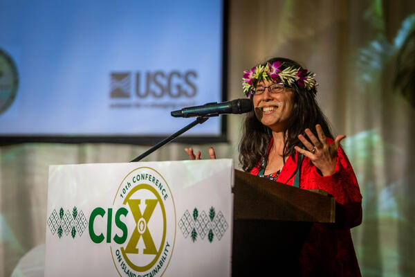
Janet Cushing, USGS, giving a presentation at the Conference on Island Stability in 2019.
A coqui frog rests on a red ti plant leaf. Native to Puerto Rico, coqui are an invasive species in Hawaii.
NW CASC’s USGS Director Nicole DeCrappeo on a recent rafting trip through the Grand Canyon on the Colorado River. She brought along a paper John Wesley Powell, an explorer and the 2nd director of the USGS, to commemorate the 150th anniversary of his historic trip down the Colorado River.
Partners discuss seasonal drought experiments.
Unuk River sampling site.
Aerial view of a southeast Louisiana coastal marsh
Aerial view of a southeast Louisiana coastal marshAerial view of a southeast Louisiana coastal marsh.
Aerial view of a southeast Louisiana coastal marsh
Aerial view of a southeast Louisiana coastal marshAerial view of a southeast Louisiana coastal marsh.
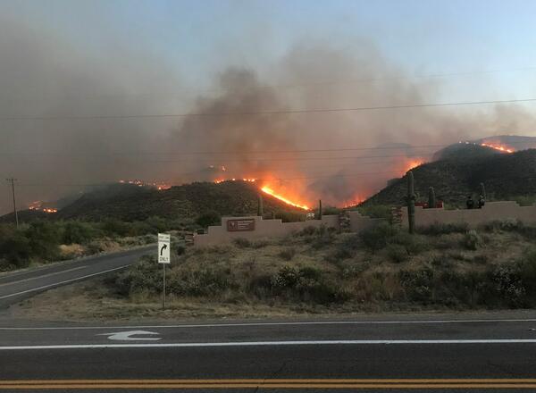
Flames from the Woodbury Fire rise above Tonto National Monument
Flames from the Woodbury Fire rise above Tonto National MonumentFlames from the Woodbury Fire rise above Tonto National Monument.
Flames from the Woodbury Fire rise above Tonto National Monument
Flames from the Woodbury Fire rise above Tonto National MonumentFlames from the Woodbury Fire rise above Tonto National Monument.
After a long day collecting cores, the team of scientists watch the sun set over the Florida Bay.
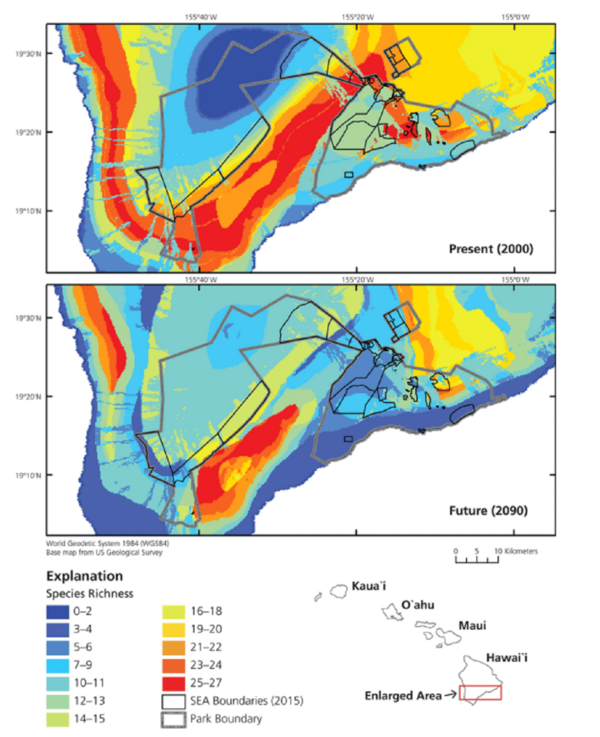
Native species richness (of the 29 species) using cool to warm colors to represent overlapping distributions of few to many species, respectively. The top panel shows that the present (year 2000) distribution of hotspots in the national park aligns well with the distribution of SEAs.
View of Nellie Juan Glacier from Wolverine Glacier
View of Nellie Juan Glacier from Wolverine GlacierView of Nellie Juan Glacier from Wolverine Glacier