U.S. flag

An official website of the United States government

Images

Explore photos, graphics, and illustrations related to projects from across the CASC Network. And be sure to check out our Climate Illustrations page, featuring free-to-download illustrations that help describe tricky climate concepts and explain how climate change affects the world around us. 

Filter Total Items: 650
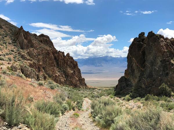
View east across Dixie Valley from the crest of the Stillwater Range, western Nevada

View east across Dixie Valley from the crest of the Stillwater Range, western Nevada. In the foreground are igneous rocks of an Oligocene caldera complex; bedrock in the Desatoya Mountains on the horizon is a slightly younger caldera complex. A major challenge for bedrock mapping is inferring what is in the subsurface between exposures like these.

View east across Dixie Valley from the crest of the Stillwater Range, western Nevada. In the foreground are igneous rocks of an Oligocene caldera complex; bedrock in the Desatoya Mountains on the horizon is a slightly younger caldera complex. A major challenge for bedrock mapping is inferring what is in the subsurface between exposures like these.

The Bandelier Tuff near Los Alamos, New Mexico

The Bandelier Tuff near Los Alamos, New Mexico.  The Jemez Mountains, home to the Valles and Toledo calderas where the tuff originated, rise in the distance.  The tuff was hot and thick when it was deposited by caldera-forming eruptions 1.61 and 1.25 million years ago, and so it is welded in places, forming a dense and resistant rock.  USGS photo by M

The Bandelier Tuff near Los Alamos, New Mexico.  The Jemez Mountains, home to the Valles and Toledo calderas where the tuff originated, rise in the distance.  The tuff was hot and thick when it was deposited by caldera-forming eruptions 1.61 and 1.25 million years ago, and so it is welded in places, forming a dense and resistant rock.  USGS photo by M

An oxbow in a river with green vegetation and foliage and blue skies.
Piscatiquis River at Medford, Maine

A photograph taken near USGS 01034000 Piscataquis River at Medford, Maine on June 6, 2022 when the river was experiencing below average flow conditions as a result of a continued drought.

Hills with patches of snow and orange coloring along the bank and vegetation along the tributary of the Agashashok River, AK
Tributary of Agashashok River, Noatak National Park and Preserve, Alaska

Tributary of Agashashok River located in the Noatak National Park and Preserve, Alaska. Recent observations from Arctic Alaska indicate that waters draining permafrost landscapes may be susceptible to iron and carbon mobilization following thaw.

Tributary of Agashashok River located in the Noatak National Park and Preserve, Alaska. Recent observations from Arctic Alaska indicate that waters draining permafrost landscapes may be susceptible to iron and carbon mobilization following thaw.

An orange inflatable raft sits on the shore of a lake
Raft containing sampling equipment on the shore of a recreational lake

An orange inflatable raft containing water sampling equipment sits on the shore of a recreational lake at Rapp Park and Recreation Area, Iowa.

Color photograph of coastline
Isaac Hale Beach Park (Pohoiki) - May 12, 2022

A view of Isaac Hale Beach Park (also known as Pohoiki) in the lower Puna District on the Island of Hawai‘i. Lava from the 2018 Kīlauea lower East Rift Zone eruption, emplaced in late July 2018, is visible on the left. USGS photo taken during a helicopter overflight on May 12, 2022, by N. Deligne.

A view of Isaac Hale Beach Park (also known as Pohoiki) in the lower Puna District on the Island of Hawai‘i. Lava from the 2018 Kīlauea lower East Rift Zone eruption, emplaced in late July 2018, is visible on the left. USGS photo taken during a helicopter overflight on May 12, 2022, by N. Deligne.

Mountain goat standing next to frozen lake
Mountain goat in Glacier National park

Mountain goat standing next to a mostly frozen, high-elevation lake in Glacier National Park, Montana. 

California Bearpoppy (Arctomecon californica) in gypsum-based soil
California Bearpoppy (Arctomecon californica)

California bearpoppy (Arctomecon californica) in gypsum-based soil. The declining abundance of this species is being actively tracked in multiple states. Photo by Morgan Andrews, SBSC, USGS.

California bearpoppy (Arctomecon californica) in gypsum-based soil. The declining abundance of this species is being actively tracked in multiple states. Photo by Morgan Andrews, SBSC, USGS.

Infographic describing biological sequestration, showing how carbon can be stored in soil and large root structures of plants
Biological Carbon Sequestration

Biological carbon sequestration is the natural ability of life and ecosystems to store carbon. Forests, peat marshes, and coastal wetlands are particularly good as storing carbon. Carbon can be stored in plant tissue, such as long-lived tree bark or in extensive root systems. Microbes break down plant and animal tissue through decomposition.

Biological carbon sequestration is the natural ability of life and ecosystems to store carbon. Forests, peat marshes, and coastal wetlands are particularly good as storing carbon. Carbon can be stored in plant tissue, such as long-lived tree bark or in extensive root systems. Microbes break down plant and animal tissue through decomposition.

A group of people stand in a circle in front of a tree-covered hill.
Stakeholder meeting at Pu'u Wa'awa'a State Forest Reserve in Hawai'i

Researchers associated with the Pacific Islands Climate Adaptation Science Center meet with potential stakeholders at the Pu'u Wa'awa'a State Forest Reserve in Hawai'i

Outstanding in the Field Episode 11 Artwork with microphone and headset graphic overlaying image of brown bears in a river.
Outstanding in the Field Episode 11 Artwork

Outstanding in the Field Episode 11 Artwork with microphone and headset graphic overlaying image of brown bears in a river.

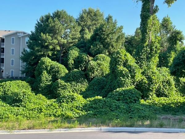
Green, leafy vines cover the trees, bushes and telephone poles on a hill outside of an apartment building
Kudzu is a voracious invasive species in the Southeast

Kudzu (genus Pueraria) is an invasive vine introduced to the United States from southeast Asia. 

scientists sampling soil at burned study site
Soil Monitoring Site in Burnt Chaparral Ecosystem

An established monitoring site to assess soil recovery in a chaparral ecosystem that burned in the 2020 LNU Lightning Complex Fire.

Low water drought conditions at Folsom Lake, California, on June 23, 2021.
Folsom_2021drought.jpg

Low water drought conditions at Folsom Lake, California, on June 23, 2021. Photo by Florence Low / California Department of Water Resources.

Low water drought conditions at Folsom Lake, California, on June 23, 2021. Photo by Florence Low / California Department of Water Resources.

photo of sagebrush landscape with blue sky
Big sagebrush landscape in northeast UT

Big sagebrush landscape under blue skies in northeast Utah. Photo by Steve Hanser (USGS)

Several birds flying low over a wetland. Mountains in the background.
Ruby Lake National Wildlife Reserve
View of Klamath Lake. Hills in the distance shrouded with low clouds and fog. Sun sits low in the sky on a late September day
Klamath Lake
Klamath Lake
Klamath Lake

View of Klamath Lake as seen by a USGS Hydrologic Technician in the field. Photo provided by Justin Willhite.

View of Klamath Lake as seen by a USGS Hydrologic Technician in the field. Photo provided by Justin Willhite.

Sunset on Lake Ontario Aboard the R/V Kaho
Lake Ontario at Sunset

Sunset on Lake Ontario aboard the USGS Great Lakes Science Center’s R/V Kaho. Photo credit: Thomas SanFilippo, USGS.

Sunset on Lake Ontario aboard the USGS Great Lakes Science Center’s R/V Kaho. Photo credit: Thomas SanFilippo, USGS.

Shrubland that has been grazed near Boulder Mountain, Utah, September 2021
Shrubland that has been grazed near Boulder Mountain, Utah

Shrubland that has been grazed near Boulder Mountain, Utah, during sunset, September 2021. Photo by Shannon Lencioni, SBSC, USGS.

Was this page helpful?