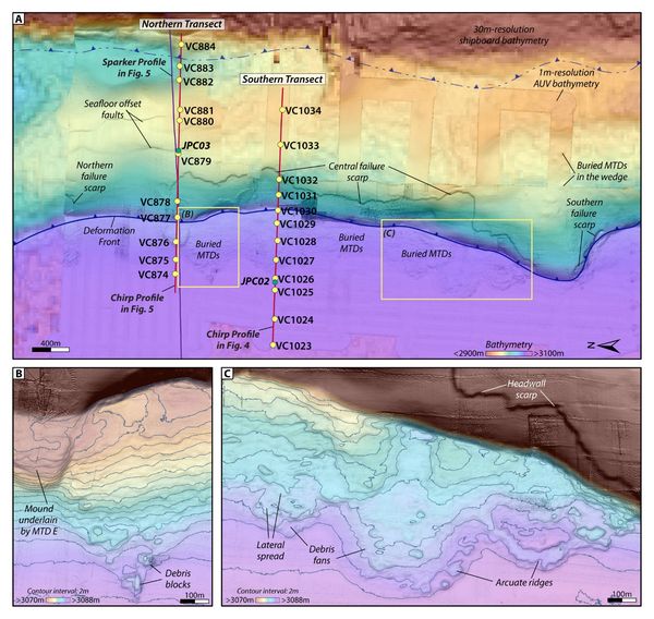
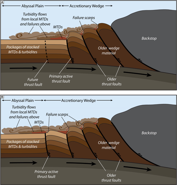
U.S. flag

An official website of the United States government

Images

Coastal and Marine Hazards and Resources Program images.

Filter Total Items: 2397
Photos of the autonomous MAPCAT cataraft being tested on a lake
Photos of the autonomous MAPCAT cataraft being tested

The Autonomous MAPping CATaraft, or “Autonomous MAPCAT”, is a remotely controlled, 14 foot long by 7 foot wide boat, built from an inflatable pontoon, aluminum frame, whitewater cataraft.

Collage of images showing natural offshore oil seepage on the California Coastline
two people smiling, equipment in the water behind them
Skilak Lake Seismograph Rescue Mission

ROV pilots Raeylynn Heinz and Alex Wick (both from OSU OOI) celebrate as their ROV and the OBS surface in Skilak Lake.

equipment underwater
Skilak Lake Seismograph Rescue Mission

View from the remotely operated vehicle (ROV) after attaching a recovery line to the ocean bottom seismograph 190 meters deep in Skilak Lake, Alaska.

View from the remotely operated vehicle (ROV) after attaching a recovery line to the ocean bottom seismograph 190 meters deep in Skilak Lake, Alaska.

person standing on sandy beach with control in hand looking at drone in the sky over cliffs
Mapping Gay Head Cliffs

The USGS Aerial Imaging and Mapping Group (AIMG) collaborated with the Wampanoag Tribe of Gay Head (Aquinnah), the Town of Aquinnah, and the Aquinnah Police Department to collect high-resolution data of the Gay Head Cliffs.

The USGS Aerial Imaging and Mapping Group (AIMG) collaborated with the Wampanoag Tribe of Gay Head (Aquinnah), the Town of Aquinnah, and the Aquinnah Police Department to collect high-resolution data of the Gay Head Cliffs.

maps showing 4-year change vs. 10-year change
Aquinnah Time Series

The USGS Aerial Imaging and Mapping Group (AIMG) collaborated with the Wampanoag Tribe of Gay Head (Aquinnah), the Town of Aquinnah, and the Aquinnah Police Department to collect high-resolution data of the Gay Head Cliffs.

The USGS Aerial Imaging and Mapping Group (AIMG) collaborated with the Wampanoag Tribe of Gay Head (Aquinnah), the Town of Aquinnah, and the Aquinnah Police Department to collect high-resolution data of the Gay Head Cliffs.

cliff backed sandy beach with two people walking on the sand
Mapping of Gay Head Cliffs

The USGS Aerial Imaging and Mapping Group (AIMG) collaborated with the Wampanoag Tribe of Gay Head (Aquinnah), the Town of Aquinnah, and the Aquinnah Police Department to collect high-resolution data of the Gay Head Cliffs.

The USGS Aerial Imaging and Mapping Group (AIMG) collaborated with the Wampanoag Tribe of Gay Head (Aquinnah), the Town of Aquinnah, and the Aquinnah Police Department to collect high-resolution data of the Gay Head Cliffs.

aerial group photo of big group outside
Special Visitors at WHCMSC

Woods Hole Coastal and Marine Science Center staff with Dave Applegate (USGS Chief Scientist and Acting Associate Director, USGS Natural Hazards Mission Area), Jonathan Godt (Program Coordinator, USGS Landslide Hazards Program), and Emily Himmelstoss (Associate Program Coordinator for Science, USGS Coastal and Marine Hazards and Resources Program) during a special v

Woods Hole Coastal and Marine Science Center staff with Dave Applegate (USGS Chief Scientist and Acting Associate Director, USGS Natural Hazards Mission Area), Jonathan Godt (Program Coordinator, USGS Landslide Hazards Program), and Emily Himmelstoss (Associate Program Coordinator for Science, USGS Coastal and Marine Hazards and Resources Program) during a special v

Detailed map showing seafloor features such as submarine canyons and slope failures offshore Kodiak Island, Alaska
USGS scientist showing visitor something on a tablet on a table outside under a tent
2025 Woods Hole Science Stroll

Meagan Eagle used a gas analyzer and respiration chamber to demonstrate the role of salt marshes in carbon sequestration.

a family with three kids visiting the USGS booth outside under a green tent
2025 Woods Hole Science Stroll

Marie Bartlett showing a family a core sample replica that displays how sediment core samples provide a layered record of past environments, climate, and geological events. 3D printed microfossils found in marine cores, such as forams and diatoms, were also on display.

Marie Bartlett showing a family a core sample replica that displays how sediment core samples provide a layered record of past environments, climate, and geological events. 3D printed microfossils found in marine cores, such as forams and diatoms, were also on display.

people taking handouts from USGS booth under tent outside on sunny day
2025 Woods Hole Science Stroll

The Science Career coloring books were super popular at the 2025 Woods Hole Science Stroll.

Man and child talking to USGS scientist at booth under tent outside
2025 Woods Hole Science Stroll

Marie Bartlett at the microscope station where visitors could look at foraminifera, tiny microfossils that live in marine environments. Scientists at the USGS use foraminifera to determine the age of sediment found many meters below the seafloor and to learn more about past climate conditions.

Marie Bartlett at the microscope station where visitors could look at foraminifera, tiny microfossils that live in marine environments. Scientists at the USGS use foraminifera to determine the age of sediment found many meters below the seafloor and to learn more about past climate conditions.

people looking at drone at USGS tent outside
2025 Woods Hole Science Stroll

Amit Millo showing off one of our drones at the 2025 Woods Hole Science Stroll on August 9, 2025. 

USGS booth under tent outside by the ocean, people talking to USGS at the booth
2025 Woods Hole Science Stroll

Marie Bartlett at the 2025 Woods Hole Science Stroll on August 9, 2025. During this free event, a variety of booths line the streets, docks, and Waterfront Park to deliver hands-on science activities, games, demonstrations, and more to visitors of all ages. 

Marie Bartlett at the 2025 Woods Hole Science Stroll on August 9, 2025. During this free event, a variety of booths line the streets, docks, and Waterfront Park to deliver hands-on science activities, games, demonstrations, and more to visitors of all ages. 

USGS scientist at booth outside with drones on it under tent outside talking to a person
2025 Woods Hole Science Stroll

Jin-Si over talking about using drones for coastal mapping. The Aerial Imaging and Mapping Group showcased uncrewed aircraft system technology (drones) of all sizes and talked about how they’re used to map short- and long-term changes in coastal landscapes. The group also flew one of the drones to demonstrate how they’re piloted.

Jin-Si over talking about using drones for coastal mapping. The Aerial Imaging and Mapping Group showcased uncrewed aircraft system technology (drones) of all sizes and talked about how they’re used to map short- and long-term changes in coastal landscapes. The group also flew one of the drones to demonstrate how they’re piloted.

USGS scientist talking to person outside at a USGS booth under a tent
2025 Woods Hole Science Stroll

Meagan Eagle used a gas analyzer and respiration chamber to demonstrate the role of salt marshes in carbon sequestration.

USGS scientist talking to two young adults at USGS booth outside under a tent
2025 Woods Hole Science Stroll

Meagan Eagle used a gas analyzer and respiration chamber to demonstrate the role of salt marshes in carbon sequestration.

People in USGS shirts behind booth outside under tent talking to visitors
2025 Woods Hole Science Stroll

The 2025 Woods Hole Science Stroll on August 9, 2025. During this free event, a variety of booths line the streets, docks, and Waterfront Park to deliver hands-on science activities, games, demonstrations, and more to visitors of all ages. 


The 2025 Woods Hole Science Stroll on August 9, 2025. During this free event, a variety of booths line the streets, docks, and Waterfront Park to deliver hands-on science activities, games, demonstrations, and more to visitors of all ages. 


people in USGS shirt smiling at child using the earthquake shake table
2025 Woods Hole Science Stroll

Anxiously waiting to see how the Lego structure does on the shake table! We setup a shake table that moves in different directions, at varying frequencies to demonstrate the power of earthquakes. People built structures out of Legos to put on the shake table to test how buildings, bridges, and other infrastructure would behave during a real seismic event.

Anxiously waiting to see how the Lego structure does on the shake table! We setup a shake table that moves in different directions, at varying frequencies to demonstrate the power of earthquakes. People built structures out of Legos to put on the shake table to test how buildings, bridges, and other infrastructure would behave during a real seismic event.

Was this page helpful?