
As sea-level rise accelerates, vegetation transitions are increasingly observed and USGS scientists are busy assessing those changes. Shoreline at the Cape Cod National Seashore in Wellfleet, MA.
Images
Coastal and Marine Hazards and Resources Program images.
Filter Total Items: 2410

Shoreline in Wellfleet
As sea-level rise accelerates, vegetation transitions are increasingly observed and USGS scientists are busy assessing those changes. Shoreline at the Cape Cod National Seashore in Wellfleet, MA.

Animated GIF showing waves breaking over a coral reef from above
Animated GIF showing waves breaking over a coral reef from aboveAnimated GIF showing waves breaking over a coral reef from above, illustrating how reefs act as natural breakwaters that dissipate wave energy.
Animated GIF showing waves breaking over a coral reef from above
Animated GIF showing waves breaking over a coral reef from aboveAnimated GIF showing waves breaking over a coral reef from above, illustrating how reefs act as natural breakwaters that dissipate wave energy.

Cover of Pacific Coastal and Marine Science Center General Information Product
Cover of Pacific Coastal and Marine Science Center General Information ProductCover of Pacific Coastal and Marine Science Center General Information Product, released on December 1, 2023.

USGS Scientists preparing Sediment Traps for deployment
USGS Scientists preparing Sediment Traps for deploymentUSGS Scientists Caitlin Reynolds and Rosalie Cruikshank are aboard the R/V Pelican in the northern Gulf of America. They are preparing two sediment traps for deployment. Sediments are caught in the large area at the top of the funnels, then collected in a bottle at the bottom.

Hydrothermal chimneys at the Eastern Galapágos Spreading Center
Hydrothermal chimneys at the Eastern Galapágos Spreading CenterHydrothermal chimneys at the Eastern Galapágos Spreading Center, from the expedition Ultra-Fine Scale Seafloor Mapping in October-November 2023.
Hydrothermal chimneys at the Eastern Galapágos Spreading Center
Hydrothermal chimneys at the Eastern Galapágos Spreading CenterHydrothermal chimneys at the Eastern Galapágos Spreading Center, from the expedition Ultra-Fine Scale Seafloor Mapping in October-November 2023.

Tubeworms found at the Eastern Galapágos Spreading Center
Tubeworms found at the Eastern Galapágos Spreading CenterTubeworms found at the Eastern Galapágos Spreading Center, from the expedition Ultra Fine-Scale Seafloor Mapping, in October-November 2023.
Tubeworms found at the Eastern Galapágos Spreading Center
Tubeworms found at the Eastern Galapágos Spreading CenterTubeworms found at the Eastern Galapágos Spreading Center, from the expedition Ultra Fine-Scale Seafloor Mapping, in October-November 2023.

Collecting sediment samples at the Eastern Galapágos Spreading Center
Collecting sediment samples at the Eastern Galapágos Spreading CenterCollecting sediment samples at the Eastern Galapágos Spreading Center, from the expedition Ultra Fine-Scale Seafloor Mapping, in October-November 2023.
Collecting sediment samples at the Eastern Galapágos Spreading Center
Collecting sediment samples at the Eastern Galapágos Spreading CenterCollecting sediment samples at the Eastern Galapágos Spreading Center, from the expedition Ultra Fine-Scale Seafloor Mapping, in October-November 2023.

Hope Ianiri and Maria Figueroa examine a sediment sample from the Eastern Galapágos Spreading Center
Hope Ianiri and Maria Figueroa examine a sediment sample from the Eastern Galapágos Spreading CenterHope Ianiri and Maria Figueroa examine a sediment sample from the Eastern Galapágos Spreading Center during the expedition Ultra Fine-Scale Seafloor Mapping.

Collecting rock samples from the Eastern Galapágos Spreading Center
Collecting rock samples from the Eastern Galapágos Spreading CenterCollecting rock samples from the Eastern Galapágos Spreading Center, during the expedition Ultra-Fine Scale Seafloor Mapping in October-November 2023.
Collecting rock samples from the Eastern Galapágos Spreading Center
Collecting rock samples from the Eastern Galapágos Spreading CenterCollecting rock samples from the Eastern Galapágos Spreading Center, during the expedition Ultra-Fine Scale Seafloor Mapping in October-November 2023.

Animated GIF showing a comparison between low-quality and high-resolution seafloor mapping
Animated GIF showing a comparison between low-quality and high-resolution seafloor mappingAnimated GIF showing a comparison between low-quality and high-resolution seafloor mapping of a deep-sea canyon system.

Animated GIF of a ship using multibeam sonar to map the seafloor
Animated GIF of a ship using multibeam sonar to map the seafloorAnimated GIF of a ship using multibeam sonar to map the seafloor, adapted from video provided by NOAA Ocean Exploration.
Animated GIF of a ship using multibeam sonar to map the seafloor
Animated GIF of a ship using multibeam sonar to map the seafloorAnimated GIF of a ship using multibeam sonar to map the seafloor, adapted from video provided by NOAA Ocean Exploration.

Diagram showing seismic profile and sediment core collected at Hosgri fault
Diagram showing seismic profile and sediment core collected at Hosgri faultCompressed high-intensity radar pulse (chirp) profile HFC-9 located south of the Cross-Hosgri slope (CHS). Profile crosses the midshelf region and images the extensive transgressive surface of erosion unconformity (blue) also seen below the CHS. The seafloor is delineated in red.

Regional map showing Hosgri fault along central California coast
Regional map showing Hosgri fault along central California coastRegional map showing the main fault structures that are part of the Pacific–North American plate boundary along central California. The San Gregorio–Hosgri fault
Regional map showing Hosgri fault along central California coast
Regional map showing Hosgri fault along central California coastRegional map showing the main fault structures that are part of the Pacific–North American plate boundary along central California. The San Gregorio–Hosgri fault

Bleaching Elkhorn coral in Buck Island Reef National Monument
Bleaching Elkhorn coral in Buck Island Reef National MonumentShown here is a photograph taken on October 20, 2023, of a wild Elkhorn coral colony in Buck Island Reef National Monument, St. Croix, VI, showing the effects of heat stress caused by elevated ocean temperatures. The heat stress causes “coral bleaching,” or the loss of nutrient-giving microscopic algae that normally live within corals.

Cross-sections of the southern Cascadia margin, showing the subsurface structure of the outer arc high
Cross-sections of the southern Cascadia margin, showing the subsurface structure of the outer arc highCross-sections of the southern Cascadia margin, showing the subsurface structure of the outer arc high, from the study Diving deeper into seep distribution along the Cascadia Convergent Margin, USA.

Regional overview map of the Cascadia convergent margin with the locations of methane seeps
Regional overview map of the Cascadia convergent margin with the locations of methane seepsRegional overview map of the Cascadia convergent margin with the locations of methane seeps, from the study Diving deeper into seep distribution along the Cascadia Convergent Margin, USA.

Close-up of a coral core aboard the Hawaiian Drowned Reefs Expedition
Close-up of a coral core aboard the Hawaiian Drowned Reefs ExpeditionClose-up of a coral core collected aboard the Hawaiian Drowned Reefs Expedition in late 2023.
Close-up of a coral core aboard the Hawaiian Drowned Reefs Expedition
Close-up of a coral core aboard the Hawaiian Drowned Reefs ExpeditionClose-up of a coral core collected aboard the Hawaiian Drowned Reefs Expedition in late 2023.

Aboard the Hawaiian Drowned Reefs Expedition, Nancy Prouty examines a coral core
Aboard the Hawaiian Drowned Reefs Expedition, Nancy Prouty examines a coral coreAboard the Hawaiian Drowned Reefs Expedition, Nancy Prouty examines a coral core collected from a drowned reef terrace.
Aboard the Hawaiian Drowned Reefs Expedition, Nancy Prouty examines a coral core
Aboard the Hawaiian Drowned Reefs Expedition, Nancy Prouty examines a coral coreAboard the Hawaiian Drowned Reefs Expedition, Nancy Prouty examines a coral core collected from a drowned reef terrace.

Section of sediment core from Rush Lake, Lower Geyser Basin, Yellowstone National Park, showing different layers that accumulated over time
Section of sediment core from Rush Lake, Lower Geyser Basin, Yellowstone National Park, showing different layers that accumulated over timeSection of a sediment core from Rush Lake, Lower Geyser Basin, Yellowstone National Park.

Hurricane Lee buoy deployment
The USGS and partners prepare to deploy 11 buoys into the Gulf of Maine from a U.S. Navy aircraft in preparation for Hurricane Lee. These buoys measure waves, temperature, and physical ocean properties.
The USGS and partners prepare to deploy 11 buoys into the Gulf of Maine from a U.S. Navy aircraft in preparation for Hurricane Lee. These buoys measure waves, temperature, and physical ocean properties.
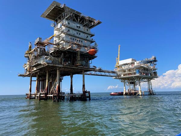
Offshore infrastructure
Photo of offshore infrastructure. Offshore Louisiana, September 2023—photo by L. Brothers.
Photo of offshore infrastructure. Offshore Louisiana, September 2023—photo by L. Brothers.