
Remote Sensing
Remote Sensing
Sensors mounted on satellites, planes, drones, and ground-based platforms monitor land cover regionally and globally. The Ecosystems Land Change Science Program uses a range of remotely sensed data (including satellite imagery, historical photographs, and land-surface feature maps) to document landscape change and drivers, improve projections of future change, and identify impacts on society.
Filter Total Items: 18

Glaciers and Landscape Change
Mountain glaciers are dynamic reservoirs of frozen water, deeply interconnected with their surrounding ecosystems. Glacier change in North America has major societal impacts, including to water resources, natural hazard risk, tourism disruption, fisheries, and global sea level change. Understanding and quantifying precise connections between changing glaciers, the surrounding landscape and climate...

SBSC: Providing Unbiased Actionable Science & Information to Support Natural Resource Management Needs of the U.S. & Department of the Interior Priorities
The U.S. Geological Survey Southwest Biological Science Center (SBSC) is uniquely positioned in the Colorado River Basin to provide sound information, specialized expertise, and innovative tools to support the management and sustained use of natural resources on public and Tribal lands in the Southwest U.S.
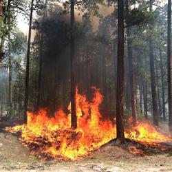
Reducing Wildfire Risks with Science
Hotter and drier conditions are making wildfires more intense and destructive across the United States. Science from the USGS Ecosystems Land Change Science Program informs local to national reduction of wildfire hazards, which saves money in avoided losses and fire suppression costs, as well as saves human lives.

Impacts of changing climate and disturbance regimes on forest ecosystem resilience in the Southern Rocky Mountains
Climate-driven forest disturbances, particularly drought-induced tree mortality and large high-severity fires from increasingly warm and dry conditions, are altering forest ecosystems and the ecosystem services society depends on (e.g., water supplies) in the Southern Rockies and across the Western U.S. We will combine unique, long-term place-based ecological data, diverse methods (e.g., paleo...

Interdisciplinary Modeling of Land Use, Climate, and Hydrologic Processes
This project focuses on development of new interdisciplinary modeling capabilities of long-term time series that capture interactions among climate, land use, water use, and water availability. Research builds on expanding the USGS Forecasting Scenarios of Land Use (FORE-SCE) model and integrating with spatially explicit models from other disciplines. Interdisciplinary models will be co-developed...

Land Change Science
Land cover change is one of the fundamental measures for understanding pressures on ecosystems and is widely used to understand the consequences to biodiversity and ecosystem services. This study utilizes land cover and other associated socioeconomic and environmental data to examine the consequences of land cover change in human-dominated landscapes, and how provisioning of ecosystem services...

Wet Snow Avalanche Research
Wet snow avalanches, including both wet slab and glide avalanches, are dangerous and can be particularly difficult to predict because they are relatively poorly understood compared to dry snow avalanches. They pose significant risk to human life and infrastructure in mountainous areas throughout the world. Wet snow avalanches are caused by weakening in the strength of the snowpack, often triggered...

Remote Sensing Tools Advance Avalanche Research
The USGS Snow and Avalanche Project (SNAP) uses remotely sensed technologies to understand snowpack changes that influence water storage, recreation, avalanche hazard and acts as a driver of landscape change. Satellites, uninhabited aerial systems (UAS), and structure-from-motion (SfM) photogrammetry are some of the tools scientists use to collect high resolution imagery that supports ongoing snow...

Arctic Biogeochemical Response to Permafrost Thaw (ABRUPT)
Warming and thawing of permafrost soils in the Arctic is expected to become widespread over the coming decades. Permafrost thaw changes ecosystem structure and function, affects resource availability for wildlife and society, and decreases ground stability which affects human infrastructure. Since permafrost soils contain about half of the global soil carbon (C) pool, the magnitude of C losses...
USGS Snow and Avalanche Project
Snow avalanches are a widespread natural hazard to humans and infrastructure as well as an important landscape disturbance affecting mountain ecosystems. Forecasting avalanche frequency is challenging on various spatial and temporal scales, and this project aims to fill a gap in snow science by focusing on reconstructing avalanche history on the continental mountain range scale - throughout the...

Past Perspectives of Water in the West
In the intermountain west, seasonal precipitation extremes, combined with population growth, are creating new challenges for the management of water resources, ecosystems, and geologic hazards. This research contributes a comprehensive long-term context for a deeper understanding of past hydrologic variability, including the magnitude and frequency of drought and flood extremes and ecosystem...

Future Scenarios of Land Use and Land Cover Change for Integrated Resources Assessment
This research project aims to develop a portfolio approach to development of land change scenarios for the United States based on empirical data and global integrated assessment modeling.This research will continue the development and capabilities of the Land Use and Carbon Scenario Simulator (LUCAS), which has been developed by USGS scientists for the purposes of projecting land change and its...