
Past Perspectives of Water in the West
In the intermountain west, seasonal precipitation extremes, combined with population growth, are creating new challenges for the management of water resources, ecosystems, and geologic hazards. This research contributes a comprehensive long-term context for a deeper understanding of past hydrologic variability, including the magnitude and frequency of drought and flood extremes and ecosystem impacts.

Statement of Problem
Water is of particular concern in the Western U.S. with the potential for future climate change leading to increasingly adverse changes in local to regional hydrologic processes. Concerns range from a decrease in availability and poorer quality of water to an increase in negative and costly extremes in drought, flood, fire, and other geologic hazards. The primary meteorological mechanisms that control Western U.S. water and climate occur within and over the Pacific Ocean, where linked oceanic and atmospheric dynamics drive atmospheric circulation patterns and associated weather. Instrumental records for the past ~100 years provide some context for precipitation patterns, but they are too short to capture the full range of known natural hydrologic and climatic variability.
Why this Research is Important
The prosperity of the American West depends on effective and strategic use of our natural water resources. By examining natural hydrologic variations over long time scales, this research provides a comprehensive context for a deeper understanding of drought and flood magnitude and frequency. This research also develops new insights into mechanisms and processes, which better inform predictions of seasonal precipitation extremes and corresponding landscape and ecosystem change.
Objective(s)
This project develops past perspectives on water in the West from geologic archives in lake and wetland sediments and tree rings. Studies test hypotheses about the causes, mechanisms and impacts of past climate on a variety of hydrologic systems, including precipitation, snowpack, lakes, wetlands, glaciers, forests, and permafrost from the present day through the last glacial period, ~30,000 years ago.
Methods
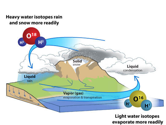
Project studies utilize water isotope tracer methods and other paleoenvironmental proxies based upon sedimentology, geochemistry and paleoecological and radiometric dating methods. Research includes the development of new paleorecords in Alaska and the Rocky Mountains. Investigations of modern water isotope-climate processes are providing a deeper understanding of the hydroclimatic information that water isotope proxy records contain.
Below are other science projects associated with this project.

How Much Snow for Colorado River Flow?

Rocky Mountain Regional Snowpack Chemistry Monitoring Study

Wetlands in the Quaternary

Holocene Synthesis Project

Holocene Hydroclimate of Western North America
In the intermountain west, seasonal precipitation extremes, combined with population growth, are creating new challenges for the management of water resources, ecosystems, and geologic hazards. This research contributes a comprehensive long-term context for a deeper understanding of past hydrologic variability, including the magnitude and frequency of drought and flood extremes and ecosystem impacts.
Statement of Problem
Water is of particular concern in the Western U.S. with the potential for future climate change leading to increasingly adverse changes in local to regional hydrologic processes. Concerns range from a decrease in availability and poorer quality of water to an increase in negative and costly extremes in drought, flood, fire, and other geologic hazards. The primary meteorological mechanisms that control Western U.S. water and climate occur within and over the Pacific Ocean, where linked oceanic and atmospheric dynamics drive atmospheric circulation patterns and associated weather. Instrumental records for the past ~100 years provide some context for precipitation patterns, but they are too short to capture the full range of known natural hydrologic and climatic variability.
Why this Research is Important
The prosperity of the American West depends on effective and strategic use of our natural water resources. By examining natural hydrologic variations over long time scales, this research provides a comprehensive context for a deeper understanding of drought and flood magnitude and frequency. This research also develops new insights into mechanisms and processes, which better inform predictions of seasonal precipitation extremes and corresponding landscape and ecosystem change.
Objective(s)
This project develops past perspectives on water in the West from geologic archives in lake and wetland sediments and tree rings. Studies test hypotheses about the causes, mechanisms and impacts of past climate on a variety of hydrologic systems, including precipitation, snowpack, lakes, wetlands, glaciers, forests, and permafrost from the present day through the last glacial period, ~30,000 years ago.
Methods
Project studies utilize water isotope tracer methods and other paleoenvironmental proxies based upon sedimentology, geochemistry and paleoecological and radiometric dating methods. Research includes the development of new paleorecords in Alaska and the Rocky Mountains. Investigations of modern water isotope-climate processes are providing a deeper understanding of the hydroclimatic information that water isotope proxy records contain.
Below are other science projects associated with this project.
How Much Snow for Colorado River Flow?
Rocky Mountain Regional Snowpack Chemistry Monitoring Study
Wetlands in the Quaternary
Holocene Synthesis Project