
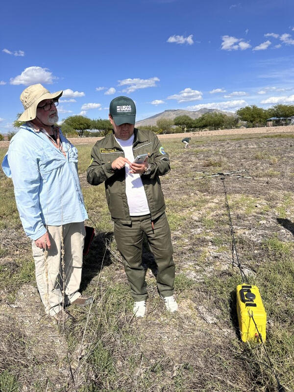
Eric White from the Hydrologic Remote Sensing Branch demonstrates a new subsurface geophysics tool in the field.
Eric A White
Eric A. White is a Hydrologist in the Hydrologic Remote Sensing Branch of the USGS Water Mission Area. Eric provides support to USGS hydrologists nationally on development and application of hydrogeophysical methods to groundwater studies, with a focus on surface, waterborne, and sUAS methods.
Science and Products
Filter Total Items: 37
Ground-Penetrating Radar in Select Peat Bogs near the Quashnet River, Mashpee/Falmouth, Massachusetts Ground-Penetrating Radar in Select Peat Bogs near the Quashnet River, Mashpee/Falmouth, Massachusetts
During December 2023, the U.S. Geological Survey collected ground-penetrating radar (GPR) data in select small peat bogs near the Quashnet River to map the depth to bedrock for use as inputs to a groundwater flow model. This data release contains the raw GPR data from 22 GPR profiles covering more than 1.8 kilometers.
Surface Nuclear Magnetic Resonance and Time-Domain Electromagnetic data in the Camas Prairie near Fairfield, south-central Idaho Surface Nuclear Magnetic Resonance and Time-Domain Electromagnetic data in the Camas Prairie near Fairfield, south-central Idaho
In cooperation with the Idaho Department of Water Resources (IDWR), the U.S. Geological Survey, (USGS), collected surface nuclear magnetic resonance (sNMR) and time-domain electromagnetic (TDEM) surveys at eight sites located in the Camas Prairie, Idaho between July 30 and August 2, 2024. The data were acquired to characterize the subsurface and define hydraulic properties of the shallow
Surface-Geophysical, Geotechnical, Hydraulic-Slug Test, Specific Conductance, and Geospatial Data for Shallow Hydrogeologic Investigations of the Tully Valley Mudboil Area, Onondaga County, New York Surface-Geophysical, Geotechnical, Hydraulic-Slug Test, Specific Conductance, and Geospatial Data for Shallow Hydrogeologic Investigations of the Tully Valley Mudboil Area, Onondaga County, New York
This data release contains data used to characterize the near-surface hydrogeology in the Tully Valley, NY mudboil area. Datasets include: (1) Surface geophysical data (Geophysical.zip) to infer different textures of unconsolidated deposits and zones of anomalously high groundwater specific conductance. These data include valley-wide surveys using two frequency domain electromagnetic
Passive and Active Seismic Data Collected Near Beaver Pond Locations in Storrs, CT; Willington, CT; and Gunnison County, CO in 2025 Passive and Active Seismic Data Collected Near Beaver Pond Locations in Storrs, CT; Willington, CT; and Gunnison County, CO in 2025
This data release documents seismic data collected immediately adjacent to beaver ponds and in their surrounding floodplain environments using active and passive seismic measurements at three sites. These sites are located in the University of Connecticut (UConn) Forest in Storrs, Connecticut; Fenton-Ruby Park in Willington, Connecticut; and in Gunnison County, Colorado. Horizontal-to...
Transient Electromagnetic Sounding Data from the Area Around the Dinero Mine Tunnel Near Leadville, Colorado Transient Electromagnetic Sounding Data from the Area Around the Dinero Mine Tunnel Near Leadville, Colorado
During August 2023, transient electromagnetic (TEM) surveys were carried out at select locations in Lake County near Leadville, Colorado upgradient from the Dinero tunnel bulkhead. TEM data were collected using an ABEM WalkTEM2 advanced instrument running acquisition software version 1.3.7.4 and using a single-turn transmitter loop (Tx) and a center-loop receiver (Rx). Tx loop dimensions...
Ground-Penetrating Radar for Depth to Bedrock in Select Watersheds near Los Planes in Southern Baja California Sur, Mexico Ground-Penetrating Radar for Depth to Bedrock in Select Watersheds near Los Planes in Southern Baja California Sur, Mexico
During December 2022 and April 2023, the U.S. Geological Survey, in cooperation with U.S. Water Partnership, collected ground-penetrating radar (GPR) data in select small subwatersheds and arroyos within the Los Planes watershed south of La Paz in southern Baja California Sur, Mexico to map the depth to bedrock for use as inputs to a groundwater flow model. This data release contains the...
Surface Geophysical Data Collected at, and Adjacent to Hanscom Air Force Base, Bedford, Massachusetts, 2024 Surface Geophysical Data Collected at, and Adjacent to Hanscom Air Force Base, Bedford, Massachusetts, 2024
In 2024 the U.S. Geological Survey (USGS), in cooperation with the Air Force Civil Engineer Center (AFCEC), conducted geophysical surveys at Hanscom Air Force Base, Hanscom Field, and surrounding areas in Massachusetts. Methods used included frequency-domain electromagnetic induction (EMI), ground-penetrating radar (GPR), horizontal-to-vertical spectral ratio (HVSR) passive seismic...
Towed transient electromagnetic survey data, Historic Jamestowne Island, Virginia, August 2021 Towed transient electromagnetic survey data, Historic Jamestowne Island, Virginia, August 2021
Towed transient electromagnetic (tTEM) data were acquired during August 2021 in Historic Jamestowne, which is part of Colonial National Historic Park of Virginia. Members of the U.S. Geological Survey, Hydrogeophysics Branch, and the Virginia-West Virginia Water Science Center collected approxximately 15.7 line kilometers of tTEM data along the the Tour Road in James City County...
Shoreline Electrical Resistivity Tomography (ERT) and Frequency Domain Electromagnetic (FDEM) Data along the Sinclair Inlet at the Bremerton Naval Complex, WA, June 2023 Shoreline Electrical Resistivity Tomography (ERT) and Frequency Domain Electromagnetic (FDEM) Data along the Sinclair Inlet at the Bremerton Naval Complex, WA, June 2023
This data release contains electrical resistivity tomography (ERT) and frequency domain electromagnetic (FDEM) data collected in areas of unwalled shoreline at the Bremerton Naval Complex, WA, June 1-5, 2023. Preliminary inverse results from the FDEM data area also included. Two sites were investigated: Charleston Beach and Segment 4. Charleston Beach is a gently sloping pebble beach...
Water-borne electromagnetic induction, handheld thermal infrared and sediment temperature, chemical, and pressure data collected at Hen Cove, Pocasset, Massachusetts, 2022 Water-borne electromagnetic induction, handheld thermal infrared and sediment temperature, chemical, and pressure data collected at Hen Cove, Pocasset, Massachusetts, 2022
Groundwater discharge points to coastal waters can be identified and quantified using natural electrical and temperature data. In August 2022, U.S. Geological Survey (USGS) collected water-borne electromagnetic induction and temperature along selected transects within Hen Cove on Cape Cod, Massachusetts, following a spatial survey of bed sediment temperature. Handheld thermal infrared...
Magnetic Survey Data in Glastonbury, Connecticut 2023 Magnetic Survey Data in Glastonbury, Connecticut 2023
A ground-based magnetic survey was conducted in Glastonbury, Connecticut. Magnetic surveys are passive, non-contact, surface geophysical methods that measure the total ambient magnetic field. The magnetic survey utilized a Geometrics G-858 MagMapper with dual cesium vapor magnetometers and a GEM Systems Base Station. Sixteen survey profiles, totaling 7 linear kilometers in length, were...
Floating Transient Electromagnetic Survey Data from the Columbia River near Hanford, WA Floating Transient Electromagnetic Survey Data from the Columbia River near Hanford, WA
This data release contains motorboat-towed floating transient electromagnetic data collected from the Columbia River near Hanford WA. Data were collected using a ~16 foot (4.9 meters) outboard motorboat during two field campaigns: July 2021 and April 2022. In total, several hundred linear kilometers of data were collected from a reach of the Columbia that extends from approximately...
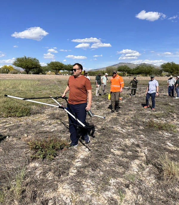
Field demonstration of subsurface geophysics tool
Eric White from the Hydrologic Remote Sensing Branch demonstrates a new subsurface geophysics tool in the field.
Field demonstration of subsurface geophysics tool
Eric White (Hydrologic Remote Sensing Branch, Water Resources Mission Area) leads a field demonstration of a new subsurface geophysics tool.
Eric White (Hydrologic Remote Sensing Branch, Water Resources Mission Area) leads a field demonstration of a new subsurface geophysics tool.
Filter Total Items: 24
Hydrogeologic conceptualization of the Arroyos subarea and Northeast Air Force Research Laboratory subarea of the Air Force Research Laboratory, Edwards Air Force Base, Antelope Valley, California, 2017–21 Hydrogeologic conceptualization of the Arroyos subarea and Northeast Air Force Research Laboratory subarea of the Air Force Research Laboratory, Edwards Air Force Base, Antelope Valley, California, 2017–21
Research and testing within the Air Force Research Laboratory at Edwards Air Force Base in the southwestern Mojave Desert has been conducted since the 1950s. This testing requires large quantities of groundwater for cooling and operations involving hazardous constituents that have entered the groundwater. To better understand the potential movement of contaminants through the groundwater...
Authors
Geoffrey Cromwell, Nicole F. Cook, Christina L. Stamos, Sarah U. Neuhaus, Christopher P. Ely, Eric White
Novel data in recreation monitoring—Summary proceedings from interagency workshops in 2019 and 2023 Novel data in recreation monitoring—Summary proceedings from interagency workshops in 2019 and 2023
Two interagency workshops were held in 2019 and 2023 in Fort Collins, Colorado, to discuss the use of novel data in recreation monitoring. During the workshops, the phrase “novel data in recreation monitoring” was primarily used to refer to data from social media, mobile device applications, and other online secondary sources. The goals of these workshops were to share information across...
Authors
Emily J. Wilkins, Christian S.L. Crowley, Eric A. White, Spencer A. Wood, Rudy Schuster
Conceptual and numerical groundwater flow model of the Cedar River alluvial aquifer system with simulation of drought stress on groundwater availability near Cedar Rapids, Iowa, for 2011 through 2013 Conceptual and numerical groundwater flow model of the Cedar River alluvial aquifer system with simulation of drought stress on groundwater availability near Cedar Rapids, Iowa, for 2011 through 2013
Between July 2011 and February 2013, the City of Cedar Rapids observed water level declines in their horizontal collector wells approaching 11 meters. As a result, pumping from these production wells had to be halted, and questions were raised about the reliability of the alluvial aquifer under future drought conditions. The U.S. Geological Survey, in cooperation with the City of Cedar...
Authors
Adel E. Haj, Wonsook S. Ha, Lance R. Gruhn, Emilia L. Bristow, Amy M. Gahala, Joshua F. Valder, Carole D. Johnson, Eric A. White, Shelby P. Sterner
Time-domain electromagnetic soundings and passive-seismic measurements for delineation of saline groundwater in the Genesee Valley-fill aquifer system, western New York, 2016–17 Time-domain electromagnetic soundings and passive-seismic measurements for delineation of saline groundwater in the Genesee Valley-fill aquifer system, western New York, 2016–17
The U.S. Geological Survey, in cooperation with the New York State Department of Environmental Conservation, used noninvasive surface geophysics in the investigation of the distribution of saline groundwater in the valley-fill aquifer system of the Genesee River Valley near the former Retsof salt mine in western New York. In 1994, the Retsof salt mine, the largest of its kind in the...
Authors
John H. Williams, William M. Kappel, Carole D. Johnson, Eric A. White, Paul M. Heisig, John W. Lane
Characterizing the diverse hydrogeology underlying rivers and estuaries using new floating transient electromagnetic methodology Characterizing the diverse hydrogeology underlying rivers and estuaries using new floating transient electromagnetic methodology
The hydrogeology below large surface water features such as rivers and estuaries is universally under-informed at the long reach to basin scales (tens of km+). This challenge inhibits the accurate modeling of fresh/saline groundwater interfaces and groundwater/surface water exchange patterns at management-relevant spatial extents. Here we introduce a towed, floating transient...
Authors
John W. Lane, Martin A. Briggs, PK Maurya, Eric A. White, JB Pedersen, Esben Auken, Neil C. Terry, Burke J. Minsley, Wade Kress, Denis R. LeBlanc, Ryan F. Adams, Carole D. Johnson
Louisiana Adaptive Management Status and Improvement Report: Vision and Recommendations Louisiana Adaptive Management Status and Improvement Report: Vision and Recommendations
As part of the process to increase implementation of adaptive management for ecosystem-based coastal restoration within Louisiana, we aim for this report to be broadly applicable across planning processes as well as funding and implementing entities. It compiles technical knowledge and guidance summarized as key findings through the text which lead to eight priority recommendations to...
Authors
Bill Boshart, Morgan Crutcher, Angelina Freeman, Edward Haywood, Syed M. Khalil, Summer Langlois, Darin L. Lee, David Lindquist, Tommy E. McGinnis, James Pahl, Carol Parsons-Richards, Erin Plitsch, Rick Raynie, Robert Routon, Leigh Anne Sharp, John Troutman, Chuck Villarrubia, Todd Folse, Alyson Graugnard, Anne Hawes, Russ Joffrion, Wes Leblanc, Brian Lezina, Jim Pahl, Jody White, Craig Conzelmann, Ann Hijuelos, Sarai Piazza, Kathryn A. Spear, Gregory D. Steyer, Nanciann Regalado, John M. Tirpak, Courtney Schupp, Melissa Carle, Jaclyn Daly, Nicolas Eckhardt, Christy Fellas, Erin M. Fougeres, Stephen Heverly, Stacey Horstman, Jason Kroll, Mel Landry, Barbara A. Schroeder, Eric Weissberger, Sara Wissman, Treda Grayson, Patricia Taylor, Danny Wiegand, Mark Defley, Paulina Kolic, Harris Bienn, Tim J. B. Carruthers, Alyssa Dausman, Alaina Grace, Scott Hemmerling, Andrea Jerabek, Eric White, Ryan Clark, Coleen McHugh, Leland C Moss, Cyndhia Ramatchandirane, Amy Wold
Wetland biomass and productivity in Coastal Louisiana: Base line data (1976-2015) and knowledge gaps for the development of spatially explicit models for ecosystem restoration and rehabilitation initiatives Wetland biomass and productivity in Coastal Louisiana: Base line data (1976-2015) and knowledge gaps for the development of spatially explicit models for ecosystem restoration and rehabilitation initiatives
Coastal Louisiana host 37% of the coastal wetland area in the conterminous US, including one of the deltaic coastal regions more susceptible to the synergy of human and natural impacts causing wetland loss. As a result of the construction of flood protection infrastructure, dredging of channels across wetlands for oil/gas exploration and maritime transport activities, coastal Coastal...
Authors
Victor H. Rivera-Monroy, Courtney Elliton, Siddhartha Narra, Ehab Meselhe, Xiaochen Zhao, Eric White, Charles E. Sasser, Jenneke M. Visser, X. Meng, Hongqing Wang, Zuo Xue, Fernando Jaramillo
Geophysical assessment of a proposed landfill site in Fredericktown, Missouri Geophysical assessment of a proposed landfill site in Fredericktown, Missouri
In June 2018, U.S. Geological Survey in cooperation with the U.S. Environmental Protection Agency (EPA) collected geophysical measurements to help evaluate the suitability of a proposed landfill site for disposing mine-waste materials in Fredericktown, MO. The geophysical investigation included electromagnetic induction, electrical resistivity tomography, horizontal-to-vertical spectral...
Authors
Carole D. Johnson, Eric A. White, Dale D. Werkema, Neil C. Terry, Stephanie N. Phillips, Robert Ford, John W. Lane
Application of a towed time-domain electromagnetic (tTEM) imaging system in Jamestown, North Dakota Application of a towed time-domain electromagnetic (tTEM) imaging system in Jamestown, North Dakota
Time-Domain Electromagnetic (EM) methods have been used for decades in support of groundwater investigations. A new towed Time-Domain EM system called “tTEM”, designed by Aarhus University, is being tested and evaluated under a collaborative research agreement with the U.S. Geological Survey (USGS). The tTEM system is rapid and efficient, providing high-resolution, nearly continuous...
Authors
Carole D. Johnson, Joshua Valder, Eric A. White, Pradip Kumar Maurya, David Hisz, John W. Lane
Use of a towed electromagnetic induction (tTem) system for shallow aquifer characterization – An example from the Mississippi Alluvial Plain Use of a towed electromagnetic induction (tTem) system for shallow aquifer characterization – An example from the Mississippi Alluvial Plain
The Mississippi Alluvial Plain (MAP) aquifer system is a vital resource that supports agriculture in one of the most productive regions of the country. The U.S. Geological Survey Water Availability and Use Science Program (WAUSP) is conducting a multi-discipline investigation of the MAP aquifer system. The investigation is utilizing borehole, surface, and airborne geophysical methods to...
Authors
Eric A. White, Carole D. Johnson, Pradip Kumar Maurya, Wade Kress, David B. Kelly, John W. Lane
Time-domain electromagnetic soundings for the delineation of saline groundwater in the Genesee River Valley, Western New York, 2016-2017 Time-domain electromagnetic soundings for the delineation of saline groundwater in the Genesee River Valley, Western New York, 2016-2017
The U.S. Geological Survey, in cooperation with the New York State Department of Environmental Conservation, is investigating the distribution of saline groundwater in the Genesee River Valley near the former Retsof salt mine (fig. 1). As part of this study, paired time-domain electromagnetic (TEM) soundings and horizontal-to-vertical spectral ratio (HVSR) seismic soundings were made at...
Authors
John H. Williams, William M. Kappel, Carole D. Johnson, Eric A. White, Paul M. Heisig, J. W. Lane
Shallow bedrock limits groundwater seepage-based headwater climate refugia Shallow bedrock limits groundwater seepage-based headwater climate refugia
Groundwater/surface-water exchanges in streams are inexorably linked to adjacent aquifer dynamics. As surface-water temperatures continue to increase with climate warming, refugia created by groundwater connectivity is expected to enable cold water fish species to survive. The shallow alluvial aquifers that source groundwater seepage to headwater streams, however, may also be sensitive...
Authors
Martin A. Briggs, John W. Lane, Craig D. Snyder, Eric A. White, Zachary Johnson, David L. Nelms, Nathaniel P. Hitt
Science and Products
Filter Total Items: 37
Ground-Penetrating Radar in Select Peat Bogs near the Quashnet River, Mashpee/Falmouth, Massachusetts Ground-Penetrating Radar in Select Peat Bogs near the Quashnet River, Mashpee/Falmouth, Massachusetts
During December 2023, the U.S. Geological Survey collected ground-penetrating radar (GPR) data in select small peat bogs near the Quashnet River to map the depth to bedrock for use as inputs to a groundwater flow model. This data release contains the raw GPR data from 22 GPR profiles covering more than 1.8 kilometers.
Surface Nuclear Magnetic Resonance and Time-Domain Electromagnetic data in the Camas Prairie near Fairfield, south-central Idaho Surface Nuclear Magnetic Resonance and Time-Domain Electromagnetic data in the Camas Prairie near Fairfield, south-central Idaho
In cooperation with the Idaho Department of Water Resources (IDWR), the U.S. Geological Survey, (USGS), collected surface nuclear magnetic resonance (sNMR) and time-domain electromagnetic (TDEM) surveys at eight sites located in the Camas Prairie, Idaho between July 30 and August 2, 2024. The data were acquired to characterize the subsurface and define hydraulic properties of the shallow
Surface-Geophysical, Geotechnical, Hydraulic-Slug Test, Specific Conductance, and Geospatial Data for Shallow Hydrogeologic Investigations of the Tully Valley Mudboil Area, Onondaga County, New York Surface-Geophysical, Geotechnical, Hydraulic-Slug Test, Specific Conductance, and Geospatial Data for Shallow Hydrogeologic Investigations of the Tully Valley Mudboil Area, Onondaga County, New York
This data release contains data used to characterize the near-surface hydrogeology in the Tully Valley, NY mudboil area. Datasets include: (1) Surface geophysical data (Geophysical.zip) to infer different textures of unconsolidated deposits and zones of anomalously high groundwater specific conductance. These data include valley-wide surveys using two frequency domain electromagnetic
Passive and Active Seismic Data Collected Near Beaver Pond Locations in Storrs, CT; Willington, CT; and Gunnison County, CO in 2025 Passive and Active Seismic Data Collected Near Beaver Pond Locations in Storrs, CT; Willington, CT; and Gunnison County, CO in 2025
This data release documents seismic data collected immediately adjacent to beaver ponds and in their surrounding floodplain environments using active and passive seismic measurements at three sites. These sites are located in the University of Connecticut (UConn) Forest in Storrs, Connecticut; Fenton-Ruby Park in Willington, Connecticut; and in Gunnison County, Colorado. Horizontal-to...
Transient Electromagnetic Sounding Data from the Area Around the Dinero Mine Tunnel Near Leadville, Colorado Transient Electromagnetic Sounding Data from the Area Around the Dinero Mine Tunnel Near Leadville, Colorado
During August 2023, transient electromagnetic (TEM) surveys were carried out at select locations in Lake County near Leadville, Colorado upgradient from the Dinero tunnel bulkhead. TEM data were collected using an ABEM WalkTEM2 advanced instrument running acquisition software version 1.3.7.4 and using a single-turn transmitter loop (Tx) and a center-loop receiver (Rx). Tx loop dimensions...
Ground-Penetrating Radar for Depth to Bedrock in Select Watersheds near Los Planes in Southern Baja California Sur, Mexico Ground-Penetrating Radar for Depth to Bedrock in Select Watersheds near Los Planes in Southern Baja California Sur, Mexico
During December 2022 and April 2023, the U.S. Geological Survey, in cooperation with U.S. Water Partnership, collected ground-penetrating radar (GPR) data in select small subwatersheds and arroyos within the Los Planes watershed south of La Paz in southern Baja California Sur, Mexico to map the depth to bedrock for use as inputs to a groundwater flow model. This data release contains the...
Surface Geophysical Data Collected at, and Adjacent to Hanscom Air Force Base, Bedford, Massachusetts, 2024 Surface Geophysical Data Collected at, and Adjacent to Hanscom Air Force Base, Bedford, Massachusetts, 2024
In 2024 the U.S. Geological Survey (USGS), in cooperation with the Air Force Civil Engineer Center (AFCEC), conducted geophysical surveys at Hanscom Air Force Base, Hanscom Field, and surrounding areas in Massachusetts. Methods used included frequency-domain electromagnetic induction (EMI), ground-penetrating radar (GPR), horizontal-to-vertical spectral ratio (HVSR) passive seismic...
Towed transient electromagnetic survey data, Historic Jamestowne Island, Virginia, August 2021 Towed transient electromagnetic survey data, Historic Jamestowne Island, Virginia, August 2021
Towed transient electromagnetic (tTEM) data were acquired during August 2021 in Historic Jamestowne, which is part of Colonial National Historic Park of Virginia. Members of the U.S. Geological Survey, Hydrogeophysics Branch, and the Virginia-West Virginia Water Science Center collected approxximately 15.7 line kilometers of tTEM data along the the Tour Road in James City County...
Shoreline Electrical Resistivity Tomography (ERT) and Frequency Domain Electromagnetic (FDEM) Data along the Sinclair Inlet at the Bremerton Naval Complex, WA, June 2023 Shoreline Electrical Resistivity Tomography (ERT) and Frequency Domain Electromagnetic (FDEM) Data along the Sinclair Inlet at the Bremerton Naval Complex, WA, June 2023
This data release contains electrical resistivity tomography (ERT) and frequency domain electromagnetic (FDEM) data collected in areas of unwalled shoreline at the Bremerton Naval Complex, WA, June 1-5, 2023. Preliminary inverse results from the FDEM data area also included. Two sites were investigated: Charleston Beach and Segment 4. Charleston Beach is a gently sloping pebble beach...
Water-borne electromagnetic induction, handheld thermal infrared and sediment temperature, chemical, and pressure data collected at Hen Cove, Pocasset, Massachusetts, 2022 Water-borne electromagnetic induction, handheld thermal infrared and sediment temperature, chemical, and pressure data collected at Hen Cove, Pocasset, Massachusetts, 2022
Groundwater discharge points to coastal waters can be identified and quantified using natural electrical and temperature data. In August 2022, U.S. Geological Survey (USGS) collected water-borne electromagnetic induction and temperature along selected transects within Hen Cove on Cape Cod, Massachusetts, following a spatial survey of bed sediment temperature. Handheld thermal infrared...
Magnetic Survey Data in Glastonbury, Connecticut 2023 Magnetic Survey Data in Glastonbury, Connecticut 2023
A ground-based magnetic survey was conducted in Glastonbury, Connecticut. Magnetic surveys are passive, non-contact, surface geophysical methods that measure the total ambient magnetic field. The magnetic survey utilized a Geometrics G-858 MagMapper with dual cesium vapor magnetometers and a GEM Systems Base Station. Sixteen survey profiles, totaling 7 linear kilometers in length, were...
Floating Transient Electromagnetic Survey Data from the Columbia River near Hanford, WA Floating Transient Electromagnetic Survey Data from the Columbia River near Hanford, WA
This data release contains motorboat-towed floating transient electromagnetic data collected from the Columbia River near Hanford WA. Data were collected using a ~16 foot (4.9 meters) outboard motorboat during two field campaigns: July 2021 and April 2022. In total, several hundred linear kilometers of data were collected from a reach of the Columbia that extends from approximately...
Field demonstration of subsurface geophysics tool
Eric White from the Hydrologic Remote Sensing Branch demonstrates a new subsurface geophysics tool in the field.
Eric White from the Hydrologic Remote Sensing Branch demonstrates a new subsurface geophysics tool in the field.
Field demonstration of subsurface geophysics tool
Eric White (Hydrologic Remote Sensing Branch, Water Resources Mission Area) leads a field demonstration of a new subsurface geophysics tool.
Eric White (Hydrologic Remote Sensing Branch, Water Resources Mission Area) leads a field demonstration of a new subsurface geophysics tool.
Filter Total Items: 24
Hydrogeologic conceptualization of the Arroyos subarea and Northeast Air Force Research Laboratory subarea of the Air Force Research Laboratory, Edwards Air Force Base, Antelope Valley, California, 2017–21 Hydrogeologic conceptualization of the Arroyos subarea and Northeast Air Force Research Laboratory subarea of the Air Force Research Laboratory, Edwards Air Force Base, Antelope Valley, California, 2017–21
Research and testing within the Air Force Research Laboratory at Edwards Air Force Base in the southwestern Mojave Desert has been conducted since the 1950s. This testing requires large quantities of groundwater for cooling and operations involving hazardous constituents that have entered the groundwater. To better understand the potential movement of contaminants through the groundwater...
Authors
Geoffrey Cromwell, Nicole F. Cook, Christina L. Stamos, Sarah U. Neuhaus, Christopher P. Ely, Eric White
Novel data in recreation monitoring—Summary proceedings from interagency workshops in 2019 and 2023 Novel data in recreation monitoring—Summary proceedings from interagency workshops in 2019 and 2023
Two interagency workshops were held in 2019 and 2023 in Fort Collins, Colorado, to discuss the use of novel data in recreation monitoring. During the workshops, the phrase “novel data in recreation monitoring” was primarily used to refer to data from social media, mobile device applications, and other online secondary sources. The goals of these workshops were to share information across...
Authors
Emily J. Wilkins, Christian S.L. Crowley, Eric A. White, Spencer A. Wood, Rudy Schuster
Conceptual and numerical groundwater flow model of the Cedar River alluvial aquifer system with simulation of drought stress on groundwater availability near Cedar Rapids, Iowa, for 2011 through 2013 Conceptual and numerical groundwater flow model of the Cedar River alluvial aquifer system with simulation of drought stress on groundwater availability near Cedar Rapids, Iowa, for 2011 through 2013
Between July 2011 and February 2013, the City of Cedar Rapids observed water level declines in their horizontal collector wells approaching 11 meters. As a result, pumping from these production wells had to be halted, and questions were raised about the reliability of the alluvial aquifer under future drought conditions. The U.S. Geological Survey, in cooperation with the City of Cedar...
Authors
Adel E. Haj, Wonsook S. Ha, Lance R. Gruhn, Emilia L. Bristow, Amy M. Gahala, Joshua F. Valder, Carole D. Johnson, Eric A. White, Shelby P. Sterner
Time-domain electromagnetic soundings and passive-seismic measurements for delineation of saline groundwater in the Genesee Valley-fill aquifer system, western New York, 2016–17 Time-domain electromagnetic soundings and passive-seismic measurements for delineation of saline groundwater in the Genesee Valley-fill aquifer system, western New York, 2016–17
The U.S. Geological Survey, in cooperation with the New York State Department of Environmental Conservation, used noninvasive surface geophysics in the investigation of the distribution of saline groundwater in the valley-fill aquifer system of the Genesee River Valley near the former Retsof salt mine in western New York. In 1994, the Retsof salt mine, the largest of its kind in the...
Authors
John H. Williams, William M. Kappel, Carole D. Johnson, Eric A. White, Paul M. Heisig, John W. Lane
Characterizing the diverse hydrogeology underlying rivers and estuaries using new floating transient electromagnetic methodology Characterizing the diverse hydrogeology underlying rivers and estuaries using new floating transient electromagnetic methodology
The hydrogeology below large surface water features such as rivers and estuaries is universally under-informed at the long reach to basin scales (tens of km+). This challenge inhibits the accurate modeling of fresh/saline groundwater interfaces and groundwater/surface water exchange patterns at management-relevant spatial extents. Here we introduce a towed, floating transient...
Authors
John W. Lane, Martin A. Briggs, PK Maurya, Eric A. White, JB Pedersen, Esben Auken, Neil C. Terry, Burke J. Minsley, Wade Kress, Denis R. LeBlanc, Ryan F. Adams, Carole D. Johnson
Louisiana Adaptive Management Status and Improvement Report: Vision and Recommendations Louisiana Adaptive Management Status and Improvement Report: Vision and Recommendations
As part of the process to increase implementation of adaptive management for ecosystem-based coastal restoration within Louisiana, we aim for this report to be broadly applicable across planning processes as well as funding and implementing entities. It compiles technical knowledge and guidance summarized as key findings through the text which lead to eight priority recommendations to...
Authors
Bill Boshart, Morgan Crutcher, Angelina Freeman, Edward Haywood, Syed M. Khalil, Summer Langlois, Darin L. Lee, David Lindquist, Tommy E. McGinnis, James Pahl, Carol Parsons-Richards, Erin Plitsch, Rick Raynie, Robert Routon, Leigh Anne Sharp, John Troutman, Chuck Villarrubia, Todd Folse, Alyson Graugnard, Anne Hawes, Russ Joffrion, Wes Leblanc, Brian Lezina, Jim Pahl, Jody White, Craig Conzelmann, Ann Hijuelos, Sarai Piazza, Kathryn A. Spear, Gregory D. Steyer, Nanciann Regalado, John M. Tirpak, Courtney Schupp, Melissa Carle, Jaclyn Daly, Nicolas Eckhardt, Christy Fellas, Erin M. Fougeres, Stephen Heverly, Stacey Horstman, Jason Kroll, Mel Landry, Barbara A. Schroeder, Eric Weissberger, Sara Wissman, Treda Grayson, Patricia Taylor, Danny Wiegand, Mark Defley, Paulina Kolic, Harris Bienn, Tim J. B. Carruthers, Alyssa Dausman, Alaina Grace, Scott Hemmerling, Andrea Jerabek, Eric White, Ryan Clark, Coleen McHugh, Leland C Moss, Cyndhia Ramatchandirane, Amy Wold
Wetland biomass and productivity in Coastal Louisiana: Base line data (1976-2015) and knowledge gaps for the development of spatially explicit models for ecosystem restoration and rehabilitation initiatives Wetland biomass and productivity in Coastal Louisiana: Base line data (1976-2015) and knowledge gaps for the development of spatially explicit models for ecosystem restoration and rehabilitation initiatives
Coastal Louisiana host 37% of the coastal wetland area in the conterminous US, including one of the deltaic coastal regions more susceptible to the synergy of human and natural impacts causing wetland loss. As a result of the construction of flood protection infrastructure, dredging of channels across wetlands for oil/gas exploration and maritime transport activities, coastal Coastal...
Authors
Victor H. Rivera-Monroy, Courtney Elliton, Siddhartha Narra, Ehab Meselhe, Xiaochen Zhao, Eric White, Charles E. Sasser, Jenneke M. Visser, X. Meng, Hongqing Wang, Zuo Xue, Fernando Jaramillo
Geophysical assessment of a proposed landfill site in Fredericktown, Missouri Geophysical assessment of a proposed landfill site in Fredericktown, Missouri
In June 2018, U.S. Geological Survey in cooperation with the U.S. Environmental Protection Agency (EPA) collected geophysical measurements to help evaluate the suitability of a proposed landfill site for disposing mine-waste materials in Fredericktown, MO. The geophysical investigation included electromagnetic induction, electrical resistivity tomography, horizontal-to-vertical spectral...
Authors
Carole D. Johnson, Eric A. White, Dale D. Werkema, Neil C. Terry, Stephanie N. Phillips, Robert Ford, John W. Lane
Application of a towed time-domain electromagnetic (tTEM) imaging system in Jamestown, North Dakota Application of a towed time-domain electromagnetic (tTEM) imaging system in Jamestown, North Dakota
Time-Domain Electromagnetic (EM) methods have been used for decades in support of groundwater investigations. A new towed Time-Domain EM system called “tTEM”, designed by Aarhus University, is being tested and evaluated under a collaborative research agreement with the U.S. Geological Survey (USGS). The tTEM system is rapid and efficient, providing high-resolution, nearly continuous...
Authors
Carole D. Johnson, Joshua Valder, Eric A. White, Pradip Kumar Maurya, David Hisz, John W. Lane
Use of a towed electromagnetic induction (tTem) system for shallow aquifer characterization – An example from the Mississippi Alluvial Plain Use of a towed electromagnetic induction (tTem) system for shallow aquifer characterization – An example from the Mississippi Alluvial Plain
The Mississippi Alluvial Plain (MAP) aquifer system is a vital resource that supports agriculture in one of the most productive regions of the country. The U.S. Geological Survey Water Availability and Use Science Program (WAUSP) is conducting a multi-discipline investigation of the MAP aquifer system. The investigation is utilizing borehole, surface, and airborne geophysical methods to...
Authors
Eric A. White, Carole D. Johnson, Pradip Kumar Maurya, Wade Kress, David B. Kelly, John W. Lane
Time-domain electromagnetic soundings for the delineation of saline groundwater in the Genesee River Valley, Western New York, 2016-2017 Time-domain electromagnetic soundings for the delineation of saline groundwater in the Genesee River Valley, Western New York, 2016-2017
The U.S. Geological Survey, in cooperation with the New York State Department of Environmental Conservation, is investigating the distribution of saline groundwater in the Genesee River Valley near the former Retsof salt mine (fig. 1). As part of this study, paired time-domain electromagnetic (TEM) soundings and horizontal-to-vertical spectral ratio (HVSR) seismic soundings were made at...
Authors
John H. Williams, William M. Kappel, Carole D. Johnson, Eric A. White, Paul M. Heisig, J. W. Lane
Shallow bedrock limits groundwater seepage-based headwater climate refugia Shallow bedrock limits groundwater seepage-based headwater climate refugia
Groundwater/surface-water exchanges in streams are inexorably linked to adjacent aquifer dynamics. As surface-water temperatures continue to increase with climate warming, refugia created by groundwater connectivity is expected to enable cold water fish species to survive. The shallow alluvial aquifers that source groundwater seepage to headwater streams, however, may also be sensitive...
Authors
Martin A. Briggs, John W. Lane, Craig D. Snyder, Eric A. White, Zachary Johnson, David L. Nelms, Nathaniel P. Hitt