
USGS scientist Collin Smith, aboard USGS research vessel Dogfish, sets out a sampling net—called a lampara net—to capture nearshore fishes in a subtidal eelgrass bed in Eagle Harbor, Bainbridge Island, Washington.
Images
Images intro.
Filter Total Items: 816

Setting out a sampling net
USGS scientist Collin Smith, aboard USGS research vessel Dogfish, sets out a sampling net—called a lampara net—to capture nearshore fishes in a subtidal eelgrass bed in Eagle Harbor, Bainbridge Island, Washington.

Eelgrass bed
Partially submerged eelgrass bed at low tide in Fay Bainbridge Park on Bainbridge Island, Washington. Eelgrass is an underwater plant that is a common sight on Puget Sound beaches when the tide is out. Healthy eelgrass indicates that water clarity is high.
Partially submerged eelgrass bed at low tide in Fay Bainbridge Park on Bainbridge Island, Washington. Eelgrass is an underwater plant that is a common sight on Puget Sound beaches when the tide is out. Healthy eelgrass indicates that water clarity is high.

Beach seine on Bainbridge Island
On Bainbridge Island, Washington, USGS scientists (left to right) Theresa "Marty" Liedtke, Lisa Gee, Ryan Tomka, and Collin Smith hauling a sampling net—called a beach seine—over an eelgrass (Zostera marina) bed. Surf smelt and sand lance spawn on the upper intertidal areas of beaches in Puget Sound.
On Bainbridge Island, Washington, USGS scientists (left to right) Theresa "Marty" Liedtke, Lisa Gee, Ryan Tomka, and Collin Smith hauling a sampling net—called a beach seine—over an eelgrass (Zostera marina) bed. Surf smelt and sand lance spawn on the upper intertidal areas of beaches in Puget Sound.

map of historic and current sage-grouse range in 2000
map of historic and current sage-grouse range in 2000Map of historic and current sage-grouse range in 2000, provided as a download from the old USGS Sagemap website.
map of historic and current sage-grouse range in 2000
map of historic and current sage-grouse range in 2000Map of historic and current sage-grouse range in 2000, provided as a download from the old USGS Sagemap website.

Turbid Coastal Plume of the Elwha River, Washington
Turbid Coastal Plume of the Elwha River, WashingtonThe turbid waters of the Elwha River and the coastal waters of the Strait of Juan de Fuca mix directly offshore of the river mouth, forming a large coastal plume. This plume is easily identified by the cloudiness of the water (or "turbidity") resulting from sediment discharged by the river. Two large dams on the Elwha River are being incrementally r

Turbid Coastal Plume of the Elwha River, Washington
Turbid Coastal Plume of the Elwha River, WashingtonThe turbid waters of the Elwha River and the coastal waters of the Strait of Juan de Fuca mix directly offshore of the river mouth, forming a large coastal plume. This plume is easily identified by the cloudiness of the water (or "turbidity") resulting from sediment discharged by the river. Two large dams on the Elwha River were incrementally r

Retrieving Sediment Instrumentation, Elwha River, Washington
Retrieving Sediment Instrumentation, Elwha River, WashingtonUSGS researchers Chris Curran and Raegan Huffman retrieve instrumentation to measure sediment concentration from the Elwha River, Washington. Two large dams on the Elwha River are being incrementally removed from 2011 to 2013 to restore river function in an important salmon-bearing river.

Rime ice coats telemetry station north of Mount St. Helens, WA
Rime ice coats telemetry station north of Mount St. Helens, WAVolcano monitoring stations must be designed to withstand harsh winter conditions.
Rime ice coats telemetry station north of Mount St. Helens, WA
Rime ice coats telemetry station north of Mount St. Helens, WAVolcano monitoring stations must be designed to withstand harsh winter conditions.

Revegetation planting day at former Lake Mills
Revegetation planting day at former Lake Mills reservoir as Glines Canyon Dam is removed. Image available at Olympic National Park flickr site.
Revegetation planting day at former Lake Mills reservoir as Glines Canyon Dam is removed. Image available at Olympic National Park flickr site.
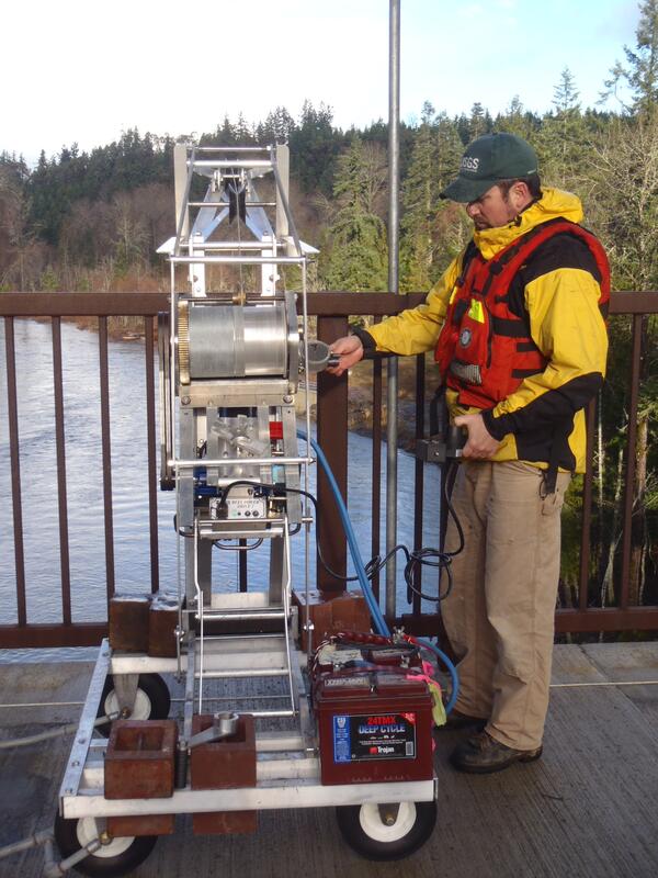
Operating Sediment-sampling Reel, Elwha River, Washington
Operating Sediment-sampling Reel, Elwha River, WashingtonUSGS hydrologic technician James Foreman operates an electronic deployment reel from a bridge over the Elwha River, Washington. Two large dams on the Elwha River are being incrementally removed from 2011 to 2013 to restore river function in an important salmon-bearing river.

Mount Adams, WA
A photograph of Mount Adams, Washington. This image was taken as part of the Land Cover Trends Project field varification for land cover data.
A photograph of Mount Adams, Washington. This image was taken as part of the Land Cover Trends Project field varification for land cover data.

Stream channel cross-section measurements—instrument that uses lase...
Stream channel cross-section measurements—instrument that uses lase...Stream channel cross-section measurements—instrument that uses laser pulses to survey distance to a reflector operated by a second crew member, Mount St. Helens.

Gas sampling with CO2 Infrared Spectrometer at Mount St. Helens
Gas sampling with CO2 Infrared Spectrometer at Mount St. HelensGas sampling with a CO2 Infrared Spectrometer at Mount St. Helens' September Lobe lava dome, Washington.
Gas sampling with CO2 Infrared Spectrometer at Mount St. Helens
Gas sampling with CO2 Infrared Spectrometer at Mount St. HelensGas sampling with a CO2 Infrared Spectrometer at Mount St. Helens' September Lobe lava dome, Washington.

Mt. St. Helens viewed at sunset
View of Mt. St. Helens at sunset, taken sometime after the crater forming eruption in 1980.
View of Mt. St. Helens at sunset, taken sometime after the crater forming eruption in 1980.

Juvenile Pacific herring with skin ulcers
Juvenile Pacific herring with skin ulcers from Ichthyophonus disease.
Juvenile Pacific herring with skin ulcers from Ichthyophonus disease.

Suspended sediment sample collection from the North Fork Toutle Riv...
Suspended sediment sample collection from the North Fork Toutle Riv...Suspended sediment sample collection from the North Fork Toutle River above the Sediment Retention Structure, downstream from Mount St. Helens.
Suspended sediment sample collection from the North Fork Toutle Riv...
Suspended sediment sample collection from the North Fork Toutle Riv...Suspended sediment sample collection from the North Fork Toutle River above the Sediment Retention Structure, downstream from Mount St. Helens.

Washington River
Beautiful River with Mount Rainier in the background
Beautiful River with Mount Rainier in the background

Mount St. Helens, as viewed from Coldwater Ridge around sunset.
Mount St. Helens, as viewed from Coldwater Ridge around sunset.Mount St. Helens, as viewed from Coldwater Ridge around sunset.
Mount St. Helens, as viewed from Coldwater Ridge around sunset.
Mount St. Helens, as viewed from Coldwater Ridge around sunset.Mount St. Helens, as viewed from Coldwater Ridge around sunset.

Seismic station VALT in Mount St. Helens crater, view toward the south
Seismic station VALT in Mount St. Helens crater, view toward the southSeismic station VALT in Mount St. Helens crater, view toward the south.
Seismic station VALT in Mount St. Helens crater, view toward the south
Seismic station VALT in Mount St. Helens crater, view toward the southSeismic station VALT in Mount St. Helens crater, view toward the south.

Juvenile Snake River fall Chinook salmon
Juvenile Snake River fall Chinook salmon.

Rufous Hummingbird in Bellingham, Washington
Rufous Hummingbird in Bellingham, Washington. Rufous Hummingbirds are present in southeast and some select southcentral locations in Alaska.
Rufous Hummingbird in Bellingham, Washington. Rufous Hummingbirds are present in southeast and some select southcentral locations in Alaska.