



A crystallized dacite flow in northern Chile. Dacite is extrusive and the volcanic equivalent of granodiorite.
Images
Browse here for some of our available imagery. We may get permission to use some non-USGS images and these should be marked and are subject to copyright laws. USGS Astrogeology images can be freely downloaded.
Filter Total Items: 330

Channelized Dacite Flow
A crystallized dacite flow in northern Chile. Dacite is extrusive and the volcanic equivalent of granodiorite.

Channelized Flow on Socompa
Channelized flows on Socompa. Socompa is a large stratovolcano on the border between Chile and Argentina, the youngest of a chain of volcanoes that runs northeast to southwest.
Channelized flows on Socompa. Socompa is a large stratovolcano on the border between Chile and Argentina, the youngest of a chain of volcanoes that runs northeast to southwest.

Burst tumulus
A burst tumulus near Kamokuna, which is a lava delta where Puʻu ʻŌʻō flows enter the Pacific Ocean. Tumuli can burst when the influx of lava is rapid compared to the rate at which the crust is thickening by cooling. In these cases the pressure driving the lava is significantly greater than the weight of the overlying crust.
A burst tumulus near Kamokuna, which is a lava delta where Puʻu ʻŌʻō flows enter the Pacific Ocean. Tumuli can burst when the influx of lava is rapid compared to the rate at which the crust is thickening by cooling. In these cases the pressure driving the lava is significantly greater than the weight of the overlying crust.

West Kamokuna Skylight
Subsequent flows have fed lava into the skylight. A stationary crust is formed on margins of the flowing lava within the tube at this location, probably due to the loss of heat through the skylight.
Subsequent flows have fed lava into the skylight. A stationary crust is formed on margins of the flowing lava within the tube at this location, probably due to the loss of heat through the skylight.

Drippy tumulus
A “drippy” tumulus near Kamokuna, which is a lava delta where Puʻu ʻŌʻō flows enter the Pacific Ocean. These tumuli form when the upwelling lava has a steady pressure and rate of movement, so the upper crust does not break apart. Instead, the lava slowly squeezes out.
A “drippy” tumulus near Kamokuna, which is a lava delta where Puʻu ʻŌʻō flows enter the Pacific Ocean. These tumuli form when the upwelling lava has a steady pressure and rate of movement, so the upper crust does not break apart. Instead, the lava slowly squeezes out.

Cinder Cone in Mount Aso
A cinder cone within the Mount Aso caldera, located on Kyushu Island, Japan. The caldera contains several cinder cones and stratovolcanoes.
A cinder cone within the Mount Aso caldera, located on Kyushu Island, Japan. The caldera contains several cinder cones and stratovolcanoes.

Flat tumulus
Flat-topped tumulus on Mauna Ulu lavas along Chain of Craters Road, Hawaii. Tumuli are just one end-member of a wide range of features formed by inflation of lava flows. A flat-topped tumulus is a half-way between a classic tumulus and a "lava-rise" or inflation plateau.
Flat-topped tumulus on Mauna Ulu lavas along Chain of Craters Road, Hawaii. Tumuli are just one end-member of a wide range of features formed by inflation of lava flows. A flat-topped tumulus is a half-way between a classic tumulus and a "lava-rise" or inflation plateau.

Flat Tumuli
Flat-topped tumulus on Mauna Ulu lavas along Chain of Craters Road, Hawaii. Tumuli are just one end-member of a wide range of features formed by inflation of lava flows. A flat-topped tumulus is a half-way between a classic tumulus and a "lava-rise" or inflation plateau.
Flat-topped tumulus on Mauna Ulu lavas along Chain of Craters Road, Hawaii. Tumuli are just one end-member of a wide range of features formed by inflation of lava flows. A flat-topped tumulus is a half-way between a classic tumulus and a "lava-rise" or inflation plateau.

Welded Scoria
Samples of welded scoria. Scoria is another word for the ‘cinders’ that make up volcanic cinder cones. Roza Member, Columbia River Basalt Group. Southeast of Winona, WA.
Samples of welded scoria. Scoria is another word for the ‘cinders’ that make up volcanic cinder cones. Roza Member, Columbia River Basalt Group. Southeast of Winona, WA.

Detail of pahoehoe lobe
A detail of a pahoehoe lobe at the top of a tumulus. The upper crust that is lifted up during the formation of a tumulus is typically quite vesicular (has lots of bubbled trapped in it). Roza Formation, Columbia River Basalt Group. Southwest of Quincy, WA.
A detail of a pahoehoe lobe at the top of a tumulus. The upper crust that is lifted up during the formation of a tumulus is typically quite vesicular (has lots of bubbled trapped in it). Roza Formation, Columbia River Basalt Group. Southwest of Quincy, WA.

Draped Scoria Cone
Draped scoria cone; partially collapsed. Roza Member, Columbia River Basalt Group. East of Winona, WA.
Draped scoria cone; partially collapsed. Roza Member, Columbia River Basalt Group. East of Winona, WA.

Bifurcating Skylight
A skylight near Pulama Pali, which is the slope where flows from Pu’u O’o make their way toward the sea. Here, the skylight allows one to see where the lava tube is splitting into two branches.
A skylight near Pulama Pali, which is the slope where flows from Pu’u O’o make their way toward the sea. Here, the skylight allows one to see where the lava tube is splitting into two branches.

Magellan Global C3-MDIR Colorized Topographic Mosaic
Magellan Global C3-MDIR Colorized Topographic MosaicThe original Magellan Compressed Mosaicked Image Data Record (C3-MIDR) archive contains three times compressed mosaics of image swaths (C-BIDRs) at a resolution of 2025 m/pixel. C3-MIDRs consist of mosaics generated by computing 3x3 pixel arithmetic moving averages from the C2-MIDRs.
Magellan Global C3-MDIR Colorized Topographic Mosaic
Magellan Global C3-MDIR Colorized Topographic MosaicThe original Magellan Compressed Mosaicked Image Data Record (C3-MIDR) archive contains three times compressed mosaics of image swaths (C-BIDRs) at a resolution of 2025 m/pixel. C3-MIDRs consist of mosaics generated by computing 3x3 pixel arithmetic moving averages from the C2-MIDRs.

Pu’u ‘Ō’ō
Pu’u ‘Ō’ō is a cinder and spatter cone in Kilauea’s east rift zone. It began erupting on January 3, 1983; a summary of its eruption can be found here. This image shows the cone just starting to form a collapse pit on its flank.
Pu’u ‘Ō’ō is a cinder and spatter cone in Kilauea’s east rift zone. It began erupting on January 3, 1983; a summary of its eruption can be found here. This image shows the cone just starting to form a collapse pit on its flank.

Pu’u ‘Ō’ō Lava Lake
View of the lava lake found inside the crater in Pu’u ‘Ō’ō cinder cone.
View of the lava lake found inside the crater in Pu’u ‘Ō’ō cinder cone.

Pu’u ‘Ō’ō Crater
View of the crater at the top of the Pu’u ‘Ō’ō cinder cone prior to the appearance of collapse pits in the flank of the cone.
View of the crater at the top of the Pu’u ‘Ō’ō cinder cone prior to the appearance of collapse pits in the flank of the cone.
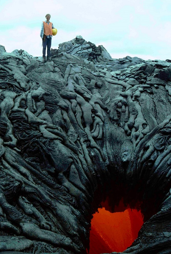
A lava skylight
Photo of an unusual lava skylight. There are photogenic toes of pahoehoe lava frozen around the sides of the skylight that are from a lava flow that moved across the skylight and sent lava cascading back into the tube.
Photo of an unusual lava skylight. There are photogenic toes of pahoehoe lava frozen around the sides of the skylight that are from a lava flow that moved across the skylight and sent lava cascading back into the tube.

China's Qaidam Basin Landscape Similar with Mars
Geologist, sedimentation expert and Mars Science Laboratory team member David Rubin of the USGS Pacific Coastal and Marine Science Center investigates longitudinal dunes in China's Qaidam Basin. He comments: "The landscape has some similarity with Mars: almost total lack of vegetation and wind-formed landscape."
Geologist, sedimentation expert and Mars Science Laboratory team member David Rubin of the USGS Pacific Coastal and Marine Science Center investigates longitudinal dunes in China's Qaidam Basin. He comments: "The landscape has some similarity with Mars: almost total lack of vegetation and wind-formed landscape."

NASA Imagery S86-27256 (June, 1986): Artist’s concept of a lunar base
NASA Imagery S86-27256 (June, 1986): Artist’s concept of a lunar baseNASA Imagery S86-27256 (June, 1986): Artist’s concept of a lunar base.
NASA Imagery S86-27256 (June, 1986): Artist’s concept of a lunar base
NASA Imagery S86-27256 (June, 1986): Artist’s concept of a lunar baseNASA Imagery S86-27256 (June, 1986): Artist’s concept of a lunar base.

USGS IMAP 1659: Geologic map of the Michelangelo Quadrangle of Mercury
USGS IMAP 1659: Geologic map of the Michelangelo Quadrangle of MercuryUSGS IMAP 1659: Geologic map of the Michelangelo Quadrangle of Mercury
By: P. D. Spudis and J.G. Prosser
Map and associated documents are available through the USGS Publications Warehouse: https://doi.org/10.3133/i1659
USGS IMAP 1659: Geologic map of the Michelangelo Quadrangle of Mercury
USGS IMAP 1659: Geologic map of the Michelangelo Quadrangle of MercuryUSGS IMAP 1659: Geologic map of the Michelangelo Quadrangle of Mercury
By: P. D. Spudis and J.G. Prosser
Map and associated documents are available through the USGS Publications Warehouse: https://doi.org/10.3133/i1659

USGS IMAP 1233: Geologic map of the Kuiper Quadrangle of Mercury
USGS IMAP 1233: Geologic map of the Kuiper Quadrangle of MercuryUSGS IMAP 1233: Geologic map of the Kuiper Quadrangle of Mercury
By: R.A. DeHon, D.H. Scott, and J.R. Underwood Jr.
Map and associated materials are available through the USGS Publications Warehouse: https://doi.org/10.3133/i1233
USGS IMAP 1233: Geologic map of the Kuiper Quadrangle of Mercury
USGS IMAP 1233: Geologic map of the Kuiper Quadrangle of MercuryUSGS IMAP 1233: Geologic map of the Kuiper Quadrangle of Mercury
By: R.A. DeHon, D.H. Scott, and J.R. Underwood Jr.
Map and associated materials are available through the USGS Publications Warehouse: https://doi.org/10.3133/i1233