
A week after Hurricane Matthew slammed through southwestern Haiti on October 4, 2016, Landsat 8's Operational Land Imager sensor provided dramatic documentation of the scope of destruction in the Caribbean country.
Images
Peruse our selection of remote sensing and Earth science imagery below.
Filter Total Items: 871

Hurricane Matthew Exacts Heavy Toll on Haiti
A week after Hurricane Matthew slammed through southwestern Haiti on October 4, 2016, Landsat 8's Operational Land Imager sensor provided dramatic documentation of the scope of destruction in the Caribbean country.

Cedar River Surges to Second-Highest Level in Eastern Iowa
Cedar River Surges to Second-Highest Level in Eastern IowaImages from Landsat 8's Operational Land Imager sensor show the dramatic transformation of the river as it flows toward Cedar Rapids. On July 8, 2016, the shallow river meanders into the city, surrounded by green crops in the heart of the growing season.

A Study in Algae
Algal blooms occur annually on Milford Lake in the summer and can be harmful to fragile wetland ecosystems. The USGS Kansas Water Science Center uses multispectral sensors on board drones to identify harmful algal blooms and study how they affect local businesses and human and animal health.
Algal blooms occur annually on Milford Lake in the summer and can be harmful to fragile wetland ecosystems. The USGS Kansas Water Science Center uses multispectral sensors on board drones to identify harmful algal blooms and study how they affect local businesses and human and animal health.

Expansion at the Port of Rotterdam
A large infrastructure project has changed the shape of the coastline of the Netherlands while increasing the cargo capacity at Europe's largest port. This pair of Landsat images spanning 15 years shows the Maasvlakte 2 project, which is an expansion of the Port of Rotterdam.
A large infrastructure project has changed the shape of the coastline of the Netherlands while increasing the cargo capacity at Europe's largest port. This pair of Landsat images spanning 15 years shows the Maasvlakte 2 project, which is an expansion of the Port of Rotterdam.

Fog on Yukon River
Fog along the Yukon River showing a Black Spruce dominated forest in the foreground, which is prone to wildfire. Photo by Bruce Wylie, USGS
Fog along the Yukon River showing a Black Spruce dominated forest in the foreground, which is prone to wildfire. Photo by Bruce Wylie, USGS

Three Gorges Dam Brings Power, Concerns to Central China
Three Gorges Dam Brings Power, Concerns to Central ChinaImages from Landsat 5 in 1993 and Landsat 8 in 2016 show how the Yangtze river transformed after the completion of the largest hydroelectric power plant in the world in 2012.
Three Gorges Dam Brings Power, Concerns to Central China
Three Gorges Dam Brings Power, Concerns to Central ChinaImages from Landsat 5 in 1993 and Landsat 8 in 2016 show how the Yangtze river transformed after the completion of the largest hydroelectric power plant in the world in 2012.

Landsat Monitors Mining at Center of North America Near Town of Center
Landsat Monitors Mining at Center of North America Near Town of CenterMining has been part of Center's history for more than a century. In August 1984, the Landsat 5 image shows significant surface mining of lignite coal just to the southeast of town, during a summer when drought had browned the countryside. Thirty-two years later, the mining activity moved to the southwest of Center.

Landsat Shows Spread of Soberanes Fire
A wildfire near Soberanes Creek along the Pacific coast of California started July 22, 2016, and spread to over 86,000 acres one month later. Landsat images from July 13, July 29, and August 14 show the dramatic progression as active fire burns orange in the latter two scenes, and smoke appears as a blue haze.
A wildfire near Soberanes Creek along the Pacific coast of California started July 22, 2016, and spread to over 86,000 acres one month later. Landsat images from July 13, July 29, and August 14 show the dramatic progression as active fire burns orange in the latter two scenes, and smoke appears as a blue haze.

Landslide Spreads 6 Miles Across Glacier Bay National Park
Landslide Spreads 6 Miles Across Glacier Bay National ParkOn June 28, 2016, a 4,000-foot-high mountainside in Glacier Bay National Park and Preserve collapsed, sending rocky debris equivalent to 60 million mid-size SUVs tumbling onto nearby Lamplugh Glacier.

Senegal shrubland - 1994
Shrubland in Senegal, photographed in 1994 by U.S. Geological Survey Scientist G. Gray Tappan as part of his work on West African land cover. Tappan photographed the scene again in 2010.
Shrubland in Senegal, photographed in 1994 by U.S. Geological Survey Scientist G. Gray Tappan as part of his work on West African land cover. Tappan photographed the scene again in 2010.

Senegal shrubland - 2010
Shrubland in Senegal, photographed in 2010 by U.S. Geological Survey Scientist G. Gray Tappan as part of his work on West African land cover. Tappan previously photographed the scene in 1994.
Shrubland in Senegal, photographed in 2010 by U.S. Geological Survey Scientist G. Gray Tappan as part of his work on West African land cover. Tappan previously photographed the scene in 1994.

Landsat Confirms Spatial Extent of Wind Tower Sediment Plumes
Landsat Confirms Spatial Extent of Wind Tower Sediment PlumesEarth observation satellites help researchers confirm the presence of large plumes containing suspended sediments extending from hundreds of wind towers in the coastal waters of the North Sea southeast of England.

Landsat Pine Beetle Pair
Landsat image taken in 1992 shows the Uinta Mountains east of Salt Lake City. The shades of dark green indicate healthy, undisturbed forest. Landsat image of the same area in 2010 captures the dramatic assault of mountain pine beetles. The dark red stains reveal widespread pine beetle destruction.
Landsat image taken in 1992 shows the Uinta Mountains east of Salt Lake City. The shades of dark green indicate healthy, undisturbed forest. Landsat image of the same area in 2010 captures the dramatic assault of mountain pine beetles. The dark red stains reveal widespread pine beetle destruction.

Landsat Monitors Gypsy Moth Damage
Massive defoliation caused by a severe outbreak of the European gypsy moth caterpillar during the spring and summer of 2016 across southern New England and the Mid-Atlantic was easily captured by the Landsat 8 Operational Land Imager sensor from 438 miles in space.
Massive defoliation caused by a severe outbreak of the European gypsy moth caterpillar during the spring and summer of 2016 across southern New England and the Mid-Atlantic was easily captured by the Landsat 8 Operational Land Imager sensor from 438 miles in space.

Canyonlands Satellite View
In September 1964, Interior Secretary Stewart Udall successfully shepherded some of the most remote and rugged terrain within the continental United States into the jurisdiction of the National Park Service (NPS) with the creation of Canyonlands National Park in southeastern Utah.
In September 1964, Interior Secretary Stewart Udall successfully shepherded some of the most remote and rugged terrain within the continental United States into the jurisdiction of the National Park Service (NPS) with the creation of Canyonlands National Park in southeastern Utah.

Kaskawulsh Glacier, Canada
The end of Kaskawulsh Glacier lies at a drainage divide. Before spring 2016, the majority of the glacier's meltwater flowed north by way of the Slims River into Kluane Lake, and from there into the Yukon River and to the Bering Sea.
The end of Kaskawulsh Glacier lies at a drainage divide. Before spring 2016, the majority of the glacier's meltwater flowed north by way of the Slims River into Kluane Lake, and from there into the Yukon River and to the Bering Sea.
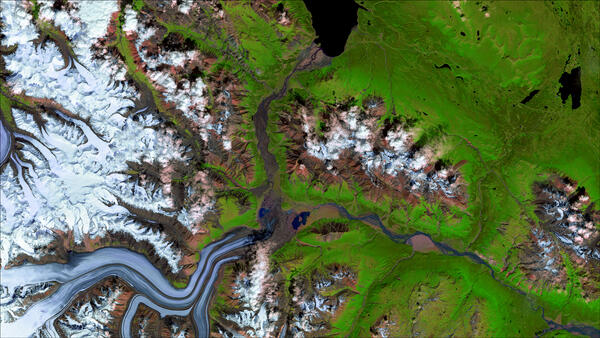
Landsat 8 image of Kaskawulsh Glacier in Canada's Yukon Territory
Landsat 8 image of Kaskawulsh Glacier in Canada's Yukon TerritoryLandsat 8 satellite image of the Kaskawulsh Glacier in Canada's Yukon Territory, showing how glacier melt has altered meltwater discharge to the Kaskawulsh River.
Landsat 8 image of Kaskawulsh Glacier in Canada's Yukon Territory
Landsat 8 image of Kaskawulsh Glacier in Canada's Yukon TerritoryLandsat 8 satellite image of the Kaskawulsh Glacier in Canada's Yukon Territory, showing how glacier melt has altered meltwater discharge to the Kaskawulsh River.

Landsat, ASTER Work Together on Russian Wildfires
Remotely sensed imagery of wildfires burning in the Siberia region of Russia shows the complementary possibilities of Landsat 8 and NASA's ASTER sensor aboard its Terra satellite.
Remotely sensed imagery of wildfires burning in the Siberia region of Russia shows the complementary possibilities of Landsat 8 and NASA's ASTER sensor aboard its Terra satellite.

Fractured
Cracking ice on the Arctic Ocean fractures like broken glass in far northern Canada. Uninhabited Eglinton Island is the land on the right. Fingers of land from Prince Patrick Island stretch downward in the upper left of the image.
Cracking ice on the Arctic Ocean fractures like broken glass in far northern Canada. Uninhabited Eglinton Island is the land on the right. Fingers of land from Prince Patrick Island stretch downward in the upper left of the image.

Landsat Monitors 1,800-Year-Old Redwoods
These Landsat images show logging’s influence around the dark green protected forests. Many of the small pink spots in the lower left corner and across the right side of the 1984 scene are logging sites revealed through Landsat 5’s Thematic Mapper sensor.
These Landsat images show logging’s influence around the dark green protected forests. Many of the small pink spots in the lower left corner and across the right side of the 1984 scene are logging sites revealed through Landsat 5’s Thematic Mapper sensor.

Landsat Reveals Scar of ‘Good Burn’ at Guadalupe Mountains
Landsat Reveals Scar of ‘Good Burn’ at Guadalupe MountainsPre- and post-fire images acquired with shortwave infrared (SWIR), near infrared (NIR), and red bands on Landsat 8’s Operational Land Imager sensor reveal a significant, 14,442-acre burn scar within the park’s high country. The burn scar appears red in the June 23 image.