
A sagebrush plant photographed at a park in Boise, Idaho. Sagebrush landscapes cover a vast part of the western U.S. but are threatened by invasive grasses and a cycle of more frequent and more intense wildfires.
Images
Peruse our selection of remote sensing and Earth science imagery below.
Filter Total Items: 871

Sagebrush plant in Boise, Idaho
A sagebrush plant photographed at a park in Boise, Idaho. Sagebrush landscapes cover a vast part of the western U.S. but are threatened by invasive grasses and a cycle of more frequent and more intense wildfires.

Landsat Science Products Analyze Water, Fire, and Snow
Landsat Science Products Analyze Water, Fire, and SnowThe USGS EROS Landsat Satellites Data System's (LSDS) Science Research and Development (LSRD) transforms Landsat data into value-added science, offering Landsat Science Products for advanced analysis of water, fire, and snow.

National Land Cover Database (NLCD) 2021: Conterminous U.S. Land Cover
National Land Cover Database (NLCD) 2021: Conterminous U.S. Land CoverMap of the Conterminous U.S. showing the Land Cover layer from the NLCD 2021.
Learn more about NLCD at www.usgs.gov/centers/eros/science/national-land-cover-database

Exterior drone image of the USGS Earth Resources Observation and Science (EROS) Center
Exterior drone image of the USGS Earth Resources Observation and Science (EROS) CenterExterior drone image of the USGS Earth Resources Observation and Science (EROS) Center near Sioux Falls, South Dakota.
Exterior drone image of the USGS Earth Resources Observation and Science (EROS) Center
Exterior drone image of the USGS Earth Resources Observation and Science (EROS) CenterExterior drone image of the USGS Earth Resources Observation and Science (EROS) Center near Sioux Falls, South Dakota.

Exterior drone image of USGS Earth Resources Observation and Science (EROS) Center
Exterior drone image of USGS Earth Resources Observation and Science (EROS) CenterAn exterior drone image of USGS Earth Resources Observation and Science (EROS) Center in summer 2023 near Sioux Falls, South Dakota.
Exterior drone image of USGS Earth Resources Observation and Science (EROS) Center
Exterior drone image of USGS Earth Resources Observation and Science (EROS) CenterAn exterior drone image of USGS Earth Resources Observation and Science (EROS) Center in summer 2023 near Sioux Falls, South Dakota.

EROS Center Director Pete Doucette
Pete Doucette was named Director of the Earth Resources Observation and Science (EROS) Center in March 2023. Listen to an Eyes on Earth podcast episode where he celebrates the past and talks about the future of EROS here.
Pete Doucette was named Director of the Earth Resources Observation and Science (EROS) Center in March 2023. Listen to an Eyes on Earth podcast episode where he celebrates the past and talks about the future of EROS here.

The EROS Ground Station
Aaron Hensley, KBR contractor at the Earth Resources Observation and Science Center, monitors the computers in the ground station.
Aaron Hensley, KBR contractor at the Earth Resources Observation and Science Center, monitors the computers in the ground station.

Landsat 9 image of Northeastern Queensland, Australia
Landsat 9 image of Northeastern Queensland, AustraliaThis Landsat 9 image displaying the coastline of Northeastern Queensland, Australia and the Cumberland Islands was acquired on July 1, and reprocessed on July 12, 2023.
Path 93 Row 74
Product ID: LC09_L1TP_093074_20230701_20230712_02_T1

Landsat Actual Evapotranspiration of Palo Verde Irrigation District, California
Landsat Actual Evapotranspiration of Palo Verde Irrigation District, CaliforniaA Landsat 9 natural color image acquired June 29, 2023 (left) and the corresponding Landsat Actual Evapotranspiration (ETa) product (right) display the properties of agricultural fields of Palo Verde Irrigation District, California.

Hovenweep supercomputer at EROS
Phill Orlick (left) and Jeff Falgout, both of the USGS, look at the Hovenweep supercomputer recently installed at the Earth Resources Observation and Science (EROS) Center.
Phill Orlick (left) and Jeff Falgout, both of the USGS, look at the Hovenweep supercomputer recently installed at the Earth Resources Observation and Science (EROS) Center.

Canada Wildfires
Smoke filled the skies over western Canada and even much of the United States in May 2023. The source was several wildfires in Alberta and British Columbia.
Landsat 9 captured this image on May 6, 2023.
Smoke filled the skies over western Canada and even much of the United States in May 2023. The source was several wildfires in Alberta and British Columbia.
Landsat 9 captured this image on May 6, 2023.

IOW Fires in Canada thumbnail
This is the thumbnail for the Image of the Week about Fires in Canada. Find more IOWs here: https://eros.usgs.gov/media-gallery/image-of-the-week.
This is the thumbnail for the Image of the Week about Fires in Canada. Find more IOWs here: https://eros.usgs.gov/media-gallery/image-of-the-week.

Charles J. Robinove
The EROS, or Earth Resources Observation Satellite, Program was formally established by Secretarial Order in 1967. Under the EROS Program, Chuck became the Associate Program Manager. In this position, Charles J. Robinove participated in international remote sensing workshops, facilitated remote sensing research, and coordinated program development.
The EROS, or Earth Resources Observation Satellite, Program was formally established by Secretarial Order in 1967. Under the EROS Program, Chuck became the Associate Program Manager. In this position, Charles J. Robinove participated in international remote sensing workshops, facilitated remote sensing research, and coordinated program development.

EROS 50th Anniversary Graphic Animated
First came the notion of viewing the Earth’s land surfaces regularly by satellite in the 1960s. Then came the launch of Landsat 1 in 1972, with scientists and governments delighting in the revelations.
First came the notion of viewing the Earth’s land surfaces regularly by satellite in the 1960s. Then came the launch of Landsat 1 in 1972, with scientists and governments delighting in the revelations.

Canada Wildfire
Smoke filled the skies over western Canada and even much of the United States in May 2023. The source was several wildfires in Alberta and British Columbia.
Near the end of May, rain and cooler temperatures finally brought some relief for the out-of-control fires.
Smoke filled the skies over western Canada and even much of the United States in May 2023. The source was several wildfires in Alberta and British Columbia.
Near the end of May, rain and cooler temperatures finally brought some relief for the out-of-control fires.

Canada Wildfires
Smoke filled the skies over western Canada and even much of the United States in May 2023. The source was several wildfires in Alberta and British Columbia.
Landsat 8 captured this image on May 26, 2023.
Smoke filled the skies over western Canada and even much of the United States in May 2023. The source was several wildfires in Alberta and British Columbia.
Landsat 8 captured this image on May 26, 2023.
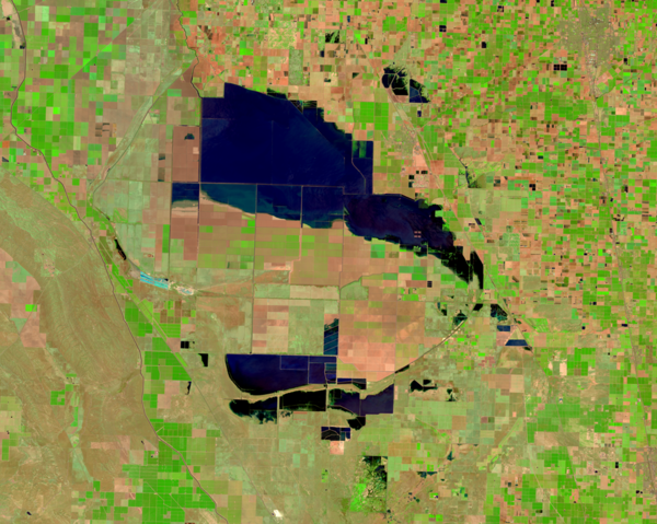
Tulare Lake Refills in 2023
The Tulare Lake Basin lies in the southern portion of the San Joaquin Valley. It once stretched up to 100 miles long and 30 miles wide. Referred to as the largest freshwater lake west of the Mississippi River, Tulare Lake appeared naturally as spring rains and snowmelt from the nearby Sierra Nevada mountain range flowed down and filled the basin.
The Tulare Lake Basin lies in the southern portion of the San Joaquin Valley. It once stretched up to 100 miles long and 30 miles wide. Referred to as the largest freshwater lake west of the Mississippi River, Tulare Lake appeared naturally as spring rains and snowmelt from the nearby Sierra Nevada mountain range flowed down and filled the basin.

USGS EROS Tour
Individuals, families, classrooms, and other organizations are all welcome to visit EROS. A free one-hour walking tour brings remote sensing science to life with satellite models, large displays, and knowledgeable staff.
Individuals, families, classrooms, and other organizations are all welcome to visit EROS. A free one-hour walking tour brings remote sensing science to life with satellite models, large displays, and knowledgeable staff.