
In November 2023 the Svartsengi volcanic system awakened after almost 800 years with a series of earthquakes that opened large cracks in the on Iceland’s Reykjanes Peninsula. An eruption on December 18th spewed lava away from the nearby coastal town of Grindavik, but the January 14, 2024 eruption sent lava directly toward the town.
Images
Peruse our selection of remote sensing and Earth science imagery below.
Filter Total Items: 864

Landsat 9 Image Captures Iceland Volcano Lava
In November 2023 the Svartsengi volcanic system awakened after almost 800 years with a series of earthquakes that opened large cracks in the on Iceland’s Reykjanes Peninsula. An eruption on December 18th spewed lava away from the nearby coastal town of Grindavik, but the January 14, 2024 eruption sent lava directly toward the town.

Fractional cover of Olifants River, Koekenaap, South Africa
Fractional cover of Olifants River, Koekenaap, South AfricaFractional cover of Olifants River, Koekenaap, South Africa, with 3-month intervals captured in 2020 processed by Digital Earth Africa with legend showing the RBG (Red-Blue-Green) breakdown. Image credit: Geoscience Australia

Field Survey on Irrigation Techniques in Mozambique
Field Survey on Irrigation Techniques in MozambiqueTimon Weitkamp and the team collecting field data on irrigation techniques in Mozambique. Photo credit: Geoscience Australia
Field Survey on Irrigation Techniques in Mozambique
Field Survey on Irrigation Techniques in MozambiqueTimon Weitkamp and the team collecting field data on irrigation techniques in Mozambique. Photo credit: Geoscience Australia

Ministry of Agriculture staff in Zambia mapping and analyzing crop production.
Ministry of Agriculture staff in Zambia mapping and analyzing crop production.Ministry of Agriculture staff in Zambia mapping and analyzing crop production. Photo credit: Geoscience Australia
Ministry of Agriculture staff in Zambia mapping and analyzing crop production.
Ministry of Agriculture staff in Zambia mapping and analyzing crop production.Ministry of Agriculture staff in Zambia mapping and analyzing crop production. Photo credit: Geoscience Australia

George Xian, a research physical scientist at EROS
George Xian, a research physical scientist at EROSGeorge Xian, a research physical scientist at the USGS Earth Resources Observation and Science (EROS) Center, works in his office.
George Xian, a research physical scientist at EROS
George Xian, a research physical scientist at EROSGeorge Xian, a research physical scientist at the USGS Earth Resources Observation and Science (EROS) Center, works in his office.

NLCD 2023 Sneak Peek!
Based on Landsat Collection 2, NLCD 2023 will offer annual products from 1985 – 2023. Depicting urban growth for the Atlanta area, this animation shows a single Landsat U.S. ARD tile of Anderson Level II land cover classification generated from the latest prototypes.
Based on Landsat Collection 2, NLCD 2023 will offer annual products from 1985 – 2023. Depicting urban growth for the Atlanta area, this animation shows a single Landsat U.S. ARD tile of Anderson Level II land cover classification generated from the latest prototypes.

Pecora Award Winner Russell Congalton Is Congratulated by EROS Chief of Staff Tim Glynn at Geo Week
Pecora Award Winner Russell Congalton Is Congratulated by EROS Chief of Staff Tim Glynn at Geo WeekPecora Award Winner Russell Congalton is congratulated by EROS Chief of Staff Tim Glynn at Geo Week in Denver. Photo credit: Shado Congalton.

Pecora Award 2024 Call for Nominations
Pecora award 2024 flyer announcing call for nominations, due May 15, 2024. This image details the procedure for nominations, eligibility, and privacy statement. Visit this USGS page for eligibility requirements and the nomination process.
Pecora award 2024 flyer announcing call for nominations, due May 15, 2024. This image details the procedure for nominations, eligibility, and privacy statement. Visit this USGS page for eligibility requirements and the nomination process.
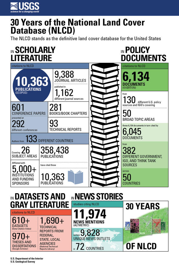
30 Years of the National Land Cover Database (NLCD)
30 Years of the National Land Cover Database (NLCD)30 Years of the National Land Cover Database (NLCD)
The NLCD stands as the definitive land cover database for the United States
30 Years of the National Land Cover Database (NLCD)
30 Years of the National Land Cover Database (NLCD)30 Years of the National Land Cover Database (NLCD)
The NLCD stands as the definitive land cover database for the United States

LCMAP CONUS Reference Data Download
An illustration of where to download LCMAP CONUS Reference Data. The Reference Data can be downloaded through ScienceBase.
An illustration of where to download LCMAP CONUS Reference Data. The Reference Data can be downloaded through ScienceBase.

An Illustration of where to download LCMAP CONUS Validation tables.
An Illustration of where to download LCMAP CONUS Validation tables.An illustration od where to download LCMAP COMUS Validation Tables. The table are located on ScienceBase.
An Illustration of where to download LCMAP CONUS Validation tables.
An Illustration of where to download LCMAP CONUS Validation tables.An illustration od where to download LCMAP COMUS Validation Tables. The table are located on ScienceBase.
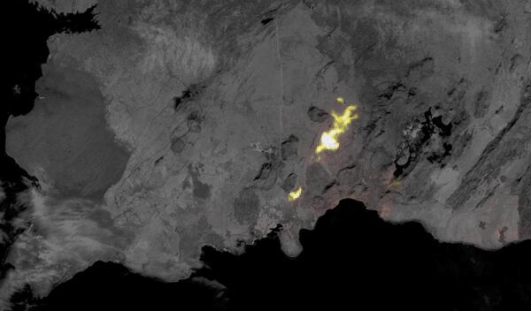
ASTER nighttime thermal image of volcano near Grindavik, Iceland
ASTER nighttime thermal image of volcano near Grindavik, IcelandThis ASTER nighttime thermal image of a volcano near Grindavik, Iceland was captured on January 24, after its eruption that started January 14 had stopped. The background image is an earlier ASTER daytime scene captured on August 15, 2022. ASTER (Advanced Spaceborne Thermal Emission and Reflection Radiometer) is an instrument resulting from a U.S.

Landsat 8 Image of Sea of Okhotsk Shoreline
This image, displaying a small area of the Sea of Okhotsk shoreline, is one of over 4,000 Landsat 8 Level-1 scenes that were acquired between January 1 and January 6, 2024, and reprocessed on January 12, 2024 with an updated Calibration Parameter file.
This image, displaying a small area of the Sea of Okhotsk shoreline, is one of over 4,000 Landsat 8 Level-1 scenes that were acquired between January 1 and January 6, 2024, and reprocessed on January 12, 2024 with an updated Calibration Parameter file.
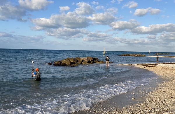
Collecting field data for bathymetry in the Florida Keys
Collecting field data for bathymetry in the Florida KeysUSGS scientists collected field data in the Florida Keys in 2023 to evaluate the accuracy of satellite-derived bathymetry, including Monica Palaseanu-Lovejoy, Jeff Danielson and Dean Gesch. USGS photo
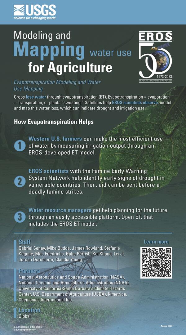
Screenshot of Evapotranspiration and Water Use poster
Screenshot of Evapotranspiration and Water Use posterScreenshot of poster created at USGS Earth Resources Observation and Science (EROS) Center titled "Modeling and Mapping Water Use for Agriculture: Evapotranspiration Modeling and Water Use Mapping."

Closeup View of Model of the Unisphere (Erosphere) Project on Display at Museum
Closeup View of Model of the Unisphere (Erosphere) Project on Display at MuseumA model of the Unisphere project on display at the Old Courthouse Museum in Sioux Falls, South Dakota. The concept of the project, originally called “Erosphere,” included a science center, farm of the future, visitor center, and space for scientific conventions.

Landsat 9 image of San Francisco Bay Area captured October 29, 2023
Landsat 9 image of San Francisco Bay Area captured October 29, 2023A Landsat 9 satellite image of the San Francisco Bay Area captured on October 29, 2023.
Landsat 9 image of San Francisco Bay Area captured October 29, 2023
Landsat 9 image of San Francisco Bay Area captured October 29, 2023A Landsat 9 satellite image of the San Francisco Bay Area captured on October 29, 2023.
Landsat 9 image of San Francisco Bay Area captured October 29, 2023
Landsat 9 image of San Francisco Bay Area captured October 29, 2023A clear Landsat 9 satellite image of the San Francisco Bay Area was captured on October 29, 2023.
Landsat 9 image of San Francisco Bay Area captured October 29, 2023
Landsat 9 image of San Francisco Bay Area captured October 29, 2023A clear Landsat 9 satellite image of the San Francisco Bay Area was captured on October 29, 2023.

Banner image for category of International Ties
The atrium of the USGS Earth Resources Observation and Science (EROS) Center contains a large revolving globe.
The atrium of the USGS Earth Resources Observation and Science (EROS) Center contains a large revolving globe.

The Landsat Flight Operations Team Monitoring Landsat 8 Maneuver
The Landsat Flight Operations Team Monitoring Landsat 8 ManeuverThis image shows the Landsat Flight Operations Team monitoring the maneuver in real time.
The Landsat Flight Operations Team Monitoring Landsat 8 Maneuver
The Landsat Flight Operations Team Monitoring Landsat 8 ManeuverThis image shows the Landsat Flight Operations Team monitoring the maneuver in real time.

Landsat Flight Operations Team
This image shows the Landsat Flight Operations Team.
This image shows the Landsat Flight Operations Team.