
Tools and Techniques
Tools and Techniques
Learn more about the tools and techniques developed by FORT researchers.
Filter Total Items: 59

Modernized Breeding Bird Survey Portal
The North American Breeding Bird Survey (BBS) Portal is a modern information system that enables volunteer observers and regional coordinators to manage survey routes, enter field data, and coordinate route assignments online. The portal replaces legacy paper-based and outdated digital workflows with a streamlined interface built for the BBS community. Observers can view their assigned routes...

Synthesis of sage-grouse genetic information to support conservation and land management actions
Sage-grouse, iconic birds of the American West, have experienced dramatic reductions and fragmentation of habitat, resulting in significant conservation concern. Genetic information can help inform priorities for protection and habitat restoration as well as strategies for translocations, but may be difficult for resource managers to find, interpret, and use in their decision making. In this work...
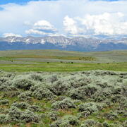
Shrubland, Alpine and Grassland Ecology (SAGE) Wildlife Research Group
The SAGE Wildlife Research Group consists of a large team of research scientists with an interest in conservation and management of wildlife and their ecosystems. Broadly, research involves understanding animal-habitat relationships, with an emphasis on conservation ecology and population demography, and a focus on shrubland, alpine, and grassland ecosystems. We are addressing the effects of...
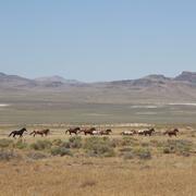
Science for management of America’s iconic wild horses and burros
Wild horses and burros are iconic wildlife of the western USA as well as a complicated management issue on tribal, state, and federal lands. Due to their history as domesticated animals, these wild equids – also called “free-roaming” or “feral” equids – can reproduce quickly, and have few natural predators, allowing their populations to grow rapidly if not managed. When populations are too large...

Greater Sage-Grouse Population Monitoring Framework: Glossary of Terms
The Greater Sage-grouse Population Monitoring Framework helps aid current assessments of sage-grouse population trends across spatial and temporal scales. It centers on four objectives: 1) create a standardized database of lek counts; 2) cluster leks to develop spatial population structures; 3) estimate spatial trends across temporal extents; and 4) develop a system to estimate where and when...

Greater Sage-Grouse Population Monitoring Framework
Greater sage-grouse ( Centrocercus urophasianus) are at the center of state and national land use policies largely because of their unique life-history traits and their role as an ecological indicator for the health of sagebrush ecosystems. Multiple science centers with the U.S. Geological Survey (USGS) in conjunction with Colorado State University (CSU) have developed the Greater Sage-Grouse...

Estimating trends for greater sage-grouse populations within highly stochastic environments
Land and wildlife managers require accurate estimates of sensitive species’ trends to help guide conservation decisions that maintain biodiversity and promote healthy ecosystems. The U.S. Geological Survey (USGS), in conjunction with Colorado State University (CSU), developed a hierarchical population monitoring framework for managing greater sage-grouse ( Centrocercus urophasianus; sage-grouse)...
AI-driven science synthesis tools for resource managers
The scientific literature is abundant on drought-related topics in the western United States, including areas of the Colorado River Basin and the sagebrush biome. Scientists, resource managers, and decision makers use this science to assess, predict, and respond to the effects of drought on people and the environment. However, it can be difficult to quickly synthesize large amounts of research. To...

USGS Sagebrush Science: Supporting Public Safety and Economic Decision Making Across the West
The sagebrush biome is one of the largest ecosystems in North America. Encompassing nearly one-third of the continental U.S., it provides critical resources for millions of Americans and a home for hundreds of plants and animal species in the West. Natural resource management in sagebrush ecosystems can be complex, and science can support management decisions by providing knowledge and tools to...
By
Core Science Systems Mission Area, Ecosystems Mission Area, Biological Threats and Invasive Species Research Program, Climate Adaptation Science Centers, Cooperative Research Units, Land Management Research Program, Species Management Research Program, Earth Resources Observation and Science (EROS) Center, Forest and Rangeland Ecosystem Science Center, Fort Collins Science Center, Northern Rocky Mountain Science Center, Southwest Biological Science Center, Western Ecological Research Center (WERC), Wildland Fire Science

Molecular Ecology Lab (MEL)
The Molecular Ecology Laboratory applies innovative genetic and genomic technologies to address a variety of complex questions and issues facing the Nation's natural resources. While we continually update the scale and efficiency of laboratory procedures to meet stakeholder needs, we must also be innovative and flexible in addressing those needs that have no off-the-shelf solution. We help...

North American Bat Monitoring Program (NABat)
Bats are essential contributing members of healthy, functioning ecosystems. They perform numerous ecosystem services like insect pest control and plant pollination, and provide enormous economic benefits through ecotourism, medical research, and novel biotechnologies. North American bats face unprecedented threats including habitat loss and fragmentation, white-nose syndrome, and wind energy...

Prioritizing restoration and conservation of Wyoming’s sagebrush ecosystems for wildlife and sagebrush connectivity
To support strategic ecosystem management across the imperiled sagebrush steppe in Wyoming, USA, we developed an extension of the Prioritizing Restoration of Sagebrush Ecosystems Tool (PReSET). Our expanded tool leverages emerging spatial data resources to provide a structured but customizable set of scenarios that can guide landscape-scale planning efforts by prioritizing conservation and...