
Web Application Development
Web Application Development
Filter Total Items: 29
Web application development to support decision making and deliver actionable science
FORT web applications support management decisions in the Department of the Interior (DOI) related to management of public lands, invasive species, outdoor recreation, and fish and wildlife health. These applications are developed in partnership with resource managers from Federal, State, local, and Tribal governments, industry, and nongovernmental organizations, empowering local and rural...

Greater Sage-Grouse Population Monitoring Framework: Cheat Sheet
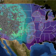
The Greater Sage-grouse Population Monitoring Framework fills a prominent information gap to help inform current assessments of sage-grouse population trends at nested spatial and temporal scales. It is centered on four objectives: (1) create a standardized database of lek counts; (2) develop biologically based spatial population structures by clustering leks; (3) estimate spatial trends at...

Greater Sage-Grouse Population Monitoring Framework: Targeted Annual Warning System Information Sheet
The Greater Sage-grouse Population Monitoring Framework helps fill a major information gap to aid current assessments of sage-grouse population trends across spatial and temporal scales. It centers on four objectives: 1) create a standardized database of lek counts; 2) cluster leks to develop spatial population structures; 3) estimate spatial trends across temporal extents; and 4) develop a system...

Greater Sage-Grouse Population Monitoring Framework: Trends Analysis Information Sheet
Land and wildlife managers require accurate estimates of sensitive species’ trends to help guide conservation decisions that maintain biodiversity and promote healthy ecosystems. Accurately assessing greater sage-grouse ( Centrocercus urophasianus; sage-grouse) population trends can be difficult because of (1) missing lek counts or incomplete repeat counts, (2) variation in counts from observer...

Greater Sage-Grouse Population Monitoring Framework: Frequently Asked Questions
The Greater Sage-grouse Population Monitoring Framework helps aid current assessments of sage-grouse population trends across spatial and temporal scales. It centers on four objectives: 1) create a standardized database of lek counts; 2) cluster leks to develop spatial population structures; 3) estimate spatial trends across temporal extents; and 4) develop a system to estimate where and when...

Greater Sage-Grouse Population Monitoring Framework
Greater sage-grouse ( Centrocercus urophasianus) are at the center of state and national land use policies largely because of their unique life-history traits and their role as an ecological indicator for the health of sagebrush ecosystems. Multiple science centers with the U.S. Geological Survey (USGS) in conjunction with Colorado State University (CSU) have developed the Greater Sage-Grouse...

A user-friendly decision support tool for monitoring and managing greater sage-grouse populations
Researchers at the U.S. Geological Survey (USGS) and Colorado State University (CSU) collaborated with the Bureau of Land Management and state wildlife agencies to develop a hierarchical population monitoring framework for managing greater sage-grouse ( Centrocercus urophasianus) populations and the sagebrush ecosystems they depend on for survival and reproduction. This greater sage-grouse...

Greater Sage-Grouse Population Monitoring Framework Data Inputs Information Sheet
To support management decisions, western state wildlife agencies identified the need for a range-wide database that tracks annual counts of greater sage-grouse ( Centrocercus urophasianus; sage-grouse) at leks (breeding sites), which have been recorded since the early 1950s. Researchers at Colorado State University (CSU) and U.S. Geological Survey (USGS) worked with state wildlife agencies to: 1)...

A targeted annual warning system (TAWS) for identifying aberrant declines in greater sage-grouse populations
Land and wildlife managers require accurate estimates of sensitive species’ trends to help guide conservation decisions that maintain biodiversity and promote healthy ecosystems. Multiple science centers with the U.S. Geological Survey (USGS), in conjunction with Colorado State University (CSU), developed a hierarchical population monitoring framework for managing greater sage-grouse (...

USGS Sagebrush Science: Supporting Public Safety and Economic Decision Making Across the West
The sagebrush biome is one of the largest ecosystems in North America. Encompassing nearly one-third of the continental U.S., it provides critical resources for millions of Americans and a home for hundreds of plants and animal species in the West. Natural resource management in sagebrush ecosystems can be complex, and science can support management decisions by providing knowledge and tools to...
By
Core Science Systems Mission Area, Ecosystems Mission Area, Biological Threats and Invasive Species Research Program, Climate Adaptation Science Centers, Cooperative Research Units, Land Management Research Program, Species Management Research Program, Earth Resources Observation and Science (EROS) Center, Forest and Rangeland Ecosystem Science Center, Fort Collins Science Center, Northern Rocky Mountain Science Center, Southwest Biological Science Center, Western Ecological Research Center (WERC), Wildland Fire Science

The Strain and Genetic Online Tissue Repository for Chronic Wasting Disease
The Strain and Genetic Online Tissue Repository (SAGOTR) is being developed by the USGS Fort Collins Science Center to document, track, discover, and request physical samples of Chronic Wasting Disease (CWD). SAGOTR connects natural resource managers, tissue repositories, and researchers in one online platform, making it easier to locate and share samples and support research and management of CWD...

North American Bat Monitoring Program (NABat)
Bats are essential contributing members of healthy, functioning ecosystems. They perform numerous ecosystem services like insect pest control and plant pollination, and provide enormous economic benefits through ecotourism, medical research, and novel biotechnologies. North American bats face unprecedented threats including habitat loss and fragmentation, white-nose syndrome, and wind energy...