
New England Water Science Center Projects
The New England Water Science Center monitors, analyzes, and communicates information on the quality and movement of surface water and groundwater within the states of Connecticut, Maine, Massachusetts, New Hampshire, Rhode Island, and Vermont.
Explore our projects to learn more about the scientific investigations we conduct. Use keywords and the available filters to narrow your search scope.
Explore Our Projects
Explore Our Projects
Filter Total Items: 102

Detailed Characterization of the Savage Superfund Site, New Hampshire
The U.S. Geological Survey (USGS), in cooperation with the U.S. Environmental Protection Agency and the New Hampshire Department of Environmental Services, is conducting advanced site characterization activities at the Savage Municipal Water Supply Superfund site in Milford, New Hampshire, and implementing new remediation efforts based on USGS science and tools.

The Aqueous Flow Concentration Estimator (AFCE): Software for Estimation of Ambient Groundwater Flow in Bedrock Open Boreholes
The U.S. Geological Survey (USGS) developed a tool that uses a chemical budget approach to help determine which fractures in a fracture zone may be dominating the water chemistry of open boreholes in bedrock aquifers. The tool uses a Monte Carlo approach and measured concentrations of anthropogenic contaminants to simulate many different scenarios and predict the most likely source direction of...

USGS Assessment of Water Resources near Hanscom Air Force Base
The United States Geological Survey (USGS) New England Water Science Center is expanding its scientific investigation to better understand the water resources at, and in the vicinity of, Hanscom Air Force Base (AFB) and the potential impacts from historical base operations and other sources.

Long Island Sound Spatially Referenced Regressions on Watershed Attributes (SPARROW) Models
The U.S. Geological Survey, New England Water Science Center, in collaboration with the U.S. Environmental Protection Agency (EPA), is modeling seasonal nutrient loads to Long Island Sound (LIS). Nutrients that originate from within the 41,867-square-mile section of the LIS watershed that is north of the Sound include both point (specific) and nonpoint (widespread) sources. Dynamic modeling of the...

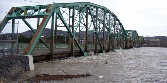
Stream Flood Vulnerability Assessment at Acadia National Park
The U.S. Geological Survey (USGS) New England Water Science Center, in cooperation with Acadia National Park, is assessing the vulnerability of the park’s streams, culverts, and bridges to flood damage and erosion using design flows for selected high streamflow recurrence intervals to inform management decisions on infrastructure upgrades.

Water Resources Inventory and Assessment at Katahdin Woods and Waters National Monument
The U.S. Geological Survey (USGS) New England Water Science Center, in cooperation with the National Park Service, is compiling and evaluating all known water resources, and documented infrastructure associated with these resources, within the Katahdin Woods and Waters National Monument and contributing associated watersheds.

Delineating High-Resolution Urban Drainage Systems for Stormwater Management in the Mystic River Watershed
Characterizing hydrology and pollutant inputs in urban watersheds requires the consideration of both the natural and manmade environment. The Mystic River Basin is a highly urbanized, 76-square-mile watershed north of Boston, Massachusetts, that includes several underserved communities. The U.S. Geological Survey (USGS) developed a watershed-scale web application of the Mystic River Basin to...

Quality of Stormwater Runoff Discharged from Connecticut Highways
Existing highway-runoff data do not adequately address the informational needs of stormwater professionals in Connecticut because there have been relatively few studies of highway runoff in the Northeastern United States. Consequently, the U.S. Geological Survey, New England Water Science Center, in cooperation with Connecticut Department of Transportation (CTDOT), is conducting a 4-year project...

Effectiveness of Open-Graded Friction Course Pavement in Reducing Suspended-Sediment Loads Discharged from Massachusetts Highways
The U.S. Geological Survey New England Water Science Center, in cooperation with Massachusetts Department of Transportation (MassDOT), is evaluating how a type of porous pavement affects the discharge of suspended sediment in comparison to the asphalt surface commonly used on Massachusetts highways. The project will expand the understanding of highway runoff concentrations of suspended sediment...

A Statewide Hydraulic Modeling Tool for Stream Crossing Projects in Massachusetts
The U.S. Geological Survey (USGS) and the University of Massachusetts at Amherst (UMass Amherst), in cooperation with the Massachusetts Department of Environmental Protection (MassDEP), began a series of studies in 2019 to develop a GIS-based hydraulic modeling tool and to provide preliminary culvert designs for stream-crossing replacement projects in Massachusetts on USGS StreamStats.

Regional Regression Equations for Estimating Selected Low-flow Statistics at Ungaged Stream Sites in Massachusetts
The U.S. Geological Survey, in cooperation with the Massachusetts Department of Recreation and Conservation, Office of Water Resources, began a study in 2019 to update the regional regression equations for estimating selected low-flow statistics at ungaged sites in Massachusetts.

Water Quality Monitoring in the Cambridge Drinking-Water Source Area, Massachusetts
The Cambridge Water Department supplies approximately 13 million gallons per day of drinking water to more than 100,000 customers. Raw water is obtained from a serial system of three primary storage reservoirs—Cambridge Reservoir (also known as the Hobbs Brook Reservoir), Stony Brook Reservoir, and Fresh Pond Reservoir—in parts of Cambridge, Lexington, Lincoln, Waltham, and Weston, Massachusetts...

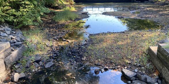
Evaluation of Lakes and Impoundments Drought Index for the Massachusetts Drought Management Plan
Lake and impoundment levels are used for calculating a drought severity index.

Effects of Sea-Level Rise and Climate Change on the Groundwater-Flow System of Martha’s Vineyard, Massachusetts
The U.S. Geological Survey (USGS), in cooperation with the Massachusetts Department of Environmental Protection (MassDEP), is investigating the effects of sea-level rise and climate change on the groundwater resources of Martha’s Vineyard, Massachusetts.

Developing Synthetic Historical Record at Groundwater Wells Using Record Extension Techniques
The Groundwater Index in the Massachusetts Drought Management Plan provides a general overview of groundwater levels relative to long-term groundwater levels in Massachusetts. The methods used to compute the Groundwater Index were revised for the 2019 version of the Drought Management Plan. The 2019 plan aligns the drought categories and specifies the drought status from select percentile ranges...

New England Lidar-Derived Hydrography Project
High-quality light detection and ranging (lidar) data from USGS 3D Elevation Program (3DEP) has unlocked the potential to derive new and innovative hydrography datasets such as the USGS next generation 3D Hydrography Program (3DHP) that can be used for many hydrologic and hydraulic (H&H) modeling applications. Federal Emergency Management Agency (FEMA) mapping partners require elevation and...

Satellite-based Remote Sensing of River Discharge
The U.S. Geological Survey and NASA are collaborating on a study to develop methods to estimate river flows from satellite observations.

Characterizing Future Climate and Hydrology in Massachusetts using Stochastic Modeling Methods
Communities across Massachusetts may face potential consequences of climate change, ranging from more extreme rainfall to more pronounced and frequent droughts. Climate change could alter the state’s hydrology in potentially complex and unanticipated ways. Typical approaches for projecting hydrologic risk under climate change can misrepresent and underestimate the variability of climate and...

Predictive Analysis of Water Demand for Providence, Rhode Island
The Providence Water Supply Board (Providence Water) and the U.S. Geological Survey (USGS) are collaborating on a study to predict future water demand in and around the city of Providence.

Base-Flow Water Quality Sampling in Small Basins Draining to Long Island Sound
During the past 20 years, nitrogen loads to Long Island Sound (LIS) have been substantially reduced in large watersheds affected by municipal wastewater loads.

Research on Per- and Polyfluoroalkyl Substances (PFAS) in the New England Water Science Center
Per- and polyfluoroalkyl substances (PFAS) are a diverse group of over 4,000 different compounds. Since the 1940s, PFAS have been manufactured and used around the globe, including in the United States. PFAS are resistant to chemical and thermal breakdown and impart stain and water-resistance properties, making them useful for a variety of commercial applications, but also persistent in the...