
Advanced Capabilities and Data Visualization
Advanced Capabilities and Data Visualization
Advanced Capabilities and Data Visualization
Filter Total Items: 38
Novel Bacterial Monitoring of Urbanized Waterways in the Lower Delaware River and Passaic River Basins.
As part of the Urban Water Federal Partnership, the U.S. Geological Survey (USGS) New Jersey Water Science Center (NJWSC) is currently assessing the use of innovative, near real-time bacteria monitoring technology to provide rapid results on bacteria concentrations to water regulators. Traditional methods of collecting and quantifying fecal indicator bacteria (FIB) is labor intensive, expensive...

New Jersey Subbasin Paired Air & Stream Water Temperature Networks
The temperature, water quality, and channel connectivity along headwater stream networks often show highly dynamic spatiotemporal patterns that are tied to localized hydrogeologic and landcover controls. Groundwater exchanges exert a spatially discontinuous influence on streams that reflect, in part, the preferential nature of groundwater discharge as controlled by recharge, topography, and...

New Jersey: Coastal Flood Inundation Mapping
The U.S. Geological Survey (USGS) in cooperation with the New Jersey Department of Environmental Protection and New Jersey Office of Emergency Management conducted a study to produce flood-inundation maps for storm surge flooding scenarios in the coastal areas of 10 New Jersey counties. The coastal storm-surge inundation maps were created from data modelled in the FEMA Region II Coastal Storm...

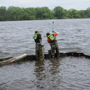
Monitoring Harmful Algal Blooms in a Coastal System to Identify the Factors that Affect HAB Production and the Downstream Transport of Cyanobacteria and Associated Cyanotoxins from Freshwater to Marine Environments
Across the nation, Cyanobacterial harmful algal blooms (HABs) in freshwater coastal lakes and ponds have become a major environmental and public health concern. Under the right conditions, cyanobacteria can produce cyanotoxins that can pose health risks to both animals and humans (U.S. Environmental Protection Agency (USEPA), 2020) and have been shown to have severe impacts on water quality...

Computing Flow Statistics in the Barnegat Bay Watershed as a Step Toward Developing Ecological Flow Targets
Ecological flows (also referred to as environmental flows) collectively describe the components of streamflow that are needed to ensure the structure and function of a stream ecosystem. Five major components of streamflow that are important in shaping ecological processes in streams are: magnitude, frequency, duration, timing, and rate of change. The US Geological Survey, in cooperation with the...

Hurricane Sandy Science, Ten-years Later
On October 29, 2012, Hurricane Sandy made landfall in New Jersey after several days of impacting the Atlantic coastline. Ten years later the impacted communities have recovered and rebuilt, and the New Jersey Water Science Center has expanded its scientific understanding of storm impacts on our state.

An Evaluation of SPATT Technology to Assess Cyanotoxins Variability and Transport in the Salem River, New Jersey
As part of the USGS Next Generation Water Observing System the NJWSC is evaluating the use of passive samplers, or Solid Phase Adsorption Toxin Tracking (SPATT) samplers, to examine the temporal variability of dissolved cyanotoxin occurrence. These innovative, low-cost, time-integrated passive samplers offer several advantages over current water-column cyanotoxin monitoring techniques. However...

Africa Groundwater Exploration and Assessment Program
The purpose of the Program is to develop a sound understanding of the potential for development of potable groundwater supply in selected African countries and build local capacity to plan and conduct the hydrologic investigations and monitoring necessary to help ensure that groundwater resources are developed and managed efficiently and sustainably.

Groundwater Exploration in Northwest Kenya, Athi and Tana River Basins
The US Geological Survey collaborated with Northern Arizona University and New Mexico State University in a project funded by the United States Agency for International Development-Kenya and East Africa Mission to investigate the use of satellite image data, along with hydrological and geological data sets, to research and develop maps of potential of groundwater resources in the Athi and Tana...

Groundwater Exploration in Northwest Kenya, Turkana and Marsabit Counties: Groundwater Potential Mapping, Hydrogeology, Economic Assessment, and Capacity Building
The US Geological Survey collaborated with Northern Arizona University and New Mexico State University in a project funded by the United States Agency for International Development-Kenya and East Africa Mission to investigate the use of satellite image data, along with hydrological and geological data sets, to research and develop maps of the potential of groundwater resources in southern Turkana...

StreamStats in New Jersey
StreamStats is a web application (Web Tool) for water-resources planning and engineering purposes. The map-based user interface can be used to delineate drainage areas for user-selected sites on streams, generate basin characteristics and estimate flow statistics for the selected sites. Users also can select the locations of USGS data-collection stations, shown as triangles on the StreamStats map...

A Field Method to Quantify Chlorinated Solvent Diffusion, Sorption, Abiotic and Biotic Degradation in Low-Permeability Zones
Strategic Environmental Research and Development Program project ER-2533 In chlorinated-solvent-contaminated fractured-sedimentary-rock aquifers, low-permeability (low-K) strata typically act as long-term or secondary sources of contamination to mobile groundwater in the high-permeability fractures. The fate of dissolved trichloroethene (TCE) in the low-K matrix is controlled by abiotic...