Could It Happen Here?
The Question: Soon after the devastating tsunamis in the Indian Ocean on December 26, 2004 and in Japan on March 11, 2011, many people have asked, "Could such a tsunami happen in the United States?"
This web page summarizes what we know about tsunamis that have struck the U.S. in the past, providing a foundation for estimating tsunami likelihood in the future. Here, we outline the sources of data that can help answer the question, and then indicate when and how large tsunamis have been for specific regions of the U.S.
What are Tsunamis?

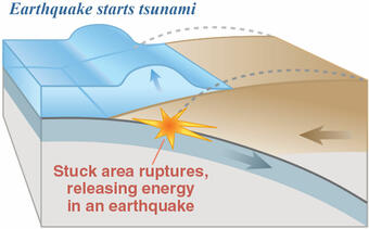
Tsunamis are ocean waves caused by large earthquakes and landslides that occur near or under the ocean. Scientists do not use the term "tidal wave" because these waves are not caused by tides. Tsunami waves are unlike typical ocean waves generated by wind and storms. When tsunamis approach shore, the behave like a very fast moving tide that extends far inland. A rule of thumb is that if you see the tsunami, it is too late to out run it. Most tsunamis do not "break" like the curling, wind-generated waves popular with surfers. Even "small" tsunamis (for example, 6 feet in height) are associated with extremely strong currents, capable of knocking someone off their feet.
Because of complex interactions with the coast, tsunami waves can persist for many hours. As with many natural phenomena, tsunamis can range in size from micro-tsunamis detectable only by sensitive instruments on the ocean floor to mega-tsunamis that can affect the coastlines of entire oceans, as with the Indian Ocean tsunami of 2004. If you hear a tsunami warning or if you feel strong shaking at the coast or very unusual wave activity (e.g., the sea withdrawing far from shore), it is important to move to high ground and stay away from the coast until wave activity has subsided (usually several hours to days). For more general information on tsunamis and what to do during a tsunami warning, please visit sites sponsored by DHS, the National Weather Service, state agencies, Pacific Marine Environmental Laboratory, NOAA, and the USGS.
Data We Can Use to Answer the Question

There are three primary sources of information we can use to answer the question Could it Happen Here?
- tsunami catalogs of historic events,
- the age of geologic deposits left by great earthquakes and tsunamis, and
- computer simulations of tsunamis from potential great earthquake and landslides around the world.
In this web page, we will focus mainly on the historic information. The National Centers for Environmental Information (part of NOAA), maintains a worldwide catalog of historic tsunamis. This catalog includes two types of measurements: runup observations from eyewitness accounts and wave height readings from tide gauge stations, most often located in harbors. In scientific terms, runup refers to the vertical height a wave reaches above a reference sea level as it washes ashore. Wave height is the vertical measurement of the wave before it reaches shore. Inundation distance is the horizontal distance a tsunami reaches landward from the shoreline. More information on tsunami measurements can be found at the NCEI Tsunami Data and Information.
Hawaiʻi

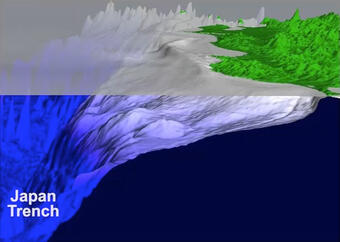
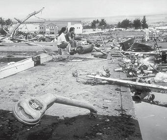
Hawaiʻi has a long recorded history of tsunamis. Tsunamis have come from both earthquakes around the Pacific rim or "Ring of Fire", termed teletsunamis or far-field tsunamis, and from earthquakes and landslides near Hawaiʻi, termed local tsunamis. The Pacific Disaster Center reports that tsunamis have accounted for more lost lives in Hawaii than the total of all other local disasters. In the 20th century, an estimated 221 people have been killed by tsunamis on the islands of Hawaiʻi. One of the largest and most devastating tsunamis Hawaiʻi has experience was a teletsunami in 1946 from an earthquake along the Aleutian subduction zone. Runup heights reached a maximum of 33-55 feet and 159 people were killed. Other important teletsunamis include one from the 1960 M=9.5 earthquake in southern Chile and one from the 1964 M=9.2 earthquake in the Gulf of Alaska. The May 22, 1960 Chile earthquake generated a 35 foot wave causing 61 deaths and \$23 million in damage. Other significant tsunamis in Hawaiʻi include: 1952 (M=9.0) Kamchatka, USSR earthquake ($1 million damage), 1957 (M=9.1) Aleutian Islands earthquake ($5 million damage).
Local tsunamis have also hit Hawaiʻi, primarily from earthquakes and large-scale subsidence along the south flank of Kilauea. The largest of these were in 1868 that killed 81 people, and another in 1975. Overall, approximately 32 tsunamis with runup greater than 1 meter have occurred in Hawaiʻi since 1811.
Read more:
- Surviving a Tsunami—Lessons from Chile, Hawaii, and Japan - USGS Circular 1187
- This Dynamic Earth: the Story of Plate Tectonics - USGS General Information Product
Alaska

Because Alaska, including the Aleutian Islands, is bordered to the south by a major subduction zone capable of generating large earthquakes, Alaska has experienced a number of damaging tsunamis. Two megathrusts have ruptured in great earthquakes: the Aleutian and Alaskan subduction zones. The Aleutian subduction zone ruptured segments in 1957 (M=9.1), 1965 (M=8.7), and 1986 (M=8.0). The Alaskan subduction zone ruptured in 1938 (M=8.2), 1946 (M=7.3), 1948 (M=7.5), and 1964 (M=9.2). By far, the one that stands out is the tsunami generated from the 1964 M=9.2 earthquake that occurred in the Gulf of Alaska. Not only was a Pacific-wide tsunami generated from this great earthquake, but landslides in the coastal fjords such as Valdez also generated localized, but extremely damaging waves. The 1964 tsunami caused damage and loss of life across the Pacific. The Pacific Tsunami Warning Center indicates that the 1964 tsunami was the most disastrous tsunami to hit the U.S. West Coast.
Alaska's famous fjords are also the source for another type of "tsunami": one in which landslides perched on the steep walls of fjords catastrophically fail and splash into the water, generating extreme wave heights, such as the 1958 Lituya Bay landslide. Again this is a localized phenomenon that does not produce teletsunamis as with tsunamis produced by great earthquakes. Overall, approximately 16 tsunamis of all sources with runup greater than 1 meter have occurred in Alaska since 1853.
Learn more about our current tsunami and earthquake research in the region:
Read articles:
- Giant waves in Lituya Bay, Alaska - USGS Professional Paper 354-C
- 1964 Great Alaska Earthquake - USGS Earthquake Hazards Program
- Source and progression of a submarine landslide and tsunami: The 1964 Great Alaska earthquake at Valdez - Pure and Applied Geophysics 2014
- A submarine landslide source for the devastating 1964 Chenega tsunami, southern Alaska - Earth and Planetary Science Letters 2016
U.S. West Coast

The historic record of tsunamis along the U.S. west coast includes mainly teletsunamis, generated from large earthquakes around the Pacific Rim. However, using detailed Japanese historic accounts, scientists have determined that a tsunami was generated on January 26, 1700 by a local earthquake close to magnitude 9, offshore of the Pacific Northwest (the Cascadia subduction zone). Geologic evidence of submerged vegetation indicates that large or great earthquakes (M=8-9) have occurred on average every 500 years along this zone, indicating that future tsunamis from the Cascadia subduction zone are possible. Great ruptures along this subduction zone would most likely cause local and possibly ocean-wide tsunamis that could affect the western United States.
Of the teletsunamis that have struck the West Coast, the 1964 Gulf of Alaska tsunami caused the most extensive damage, particularly in Crescent City, California. Overall, approximately 28 tsunamis with runup greater than 1 meter have occurred along the U.S. West Coast since 1812.
Learn more about our current tsunami and earthquake research in the region:
Read USGS publications:
- Airborne Hunt for Faults in the Portland-Vancouver Area - USGS Fact Sheet 105-96
- Averting Surprises in the Pacific Northwest - USGS Fact Sheet 111-95
- Helping Coastal Communities at Risk from Tsunamis–The Role of U.S. Geological Survey Research - USGS Fact Sheet 150-00
- Local Tsunami Hazards in the Pacific Northwest from Cascadia Subduction Zone Earthquakes - USGS Professional Paper 1661-B
U.S. Gulf Coast

In historic times, tsunami waves recorded along the Gulf Coast have all been less than 1 meter. Some of the reports are from the 1964 Gulf of Alaska earthquake recorded in Louisiana and Texas and are technically termed a seiche. A seiche is an oscillation of a body of water, typically caused by atmospheric disturbances, but in this case caused by the ground motion from the earthquake. Seiches can also occur in lakes from earthquake movements. There are a couple of early 20th-century reports of tsunami waves from Caribbean earthquakes along the Gulf Coast that are difficult to evaluate, but the wave heights all appear to be less than 1 meter.
Read Improving Earthquake and Tsunami Warnings for the Caribbean Sea, the Gulf of America, and the Atlantic Coast - USGS Fact Sheet 2006-3012
U.S. East Coast

Because there are no major subduction zones in the Atlantic Ocean, except for where it borders the Caribbean Sea, there has been a relatively low frequency of tsunamis compared to the Pacific Ocean. The most famous Atlantic tsunami is the 1755 Lisbon tsunami that was generated by an earthquake on a fault offshore Portugal. The most noteworthy North America local tsunami is the 1929 M=7.2 Grand Banks earthquake near Newfoundland, Canada (see also, Wikipedia). This is a complex event; most, if not all, of the tsunami energy may have been triggered by a submarine landslide. The maximum tsunami runup from this event was 2-7 meters concentrated on the coast of Newfoundland, though it was recorded as far south as South Carolina. Like the Gulf Coast, there a couple of reports of small tsunamis from Caribbean earthquakes, all less than 1 meter.
Read more:
- Improving Earthquake and Tsunami Warnings for the Caribbean Sea, the Gulf of America, and the Atlantic Coast - USGS Fact Sheet 2006-3012
- Assessment of tsunami hazard to the U.S. Atlantic margin - Marine Geology 353
Puerto Rico/U.S. Virgin Islands - Puerto Rico/Islas Vírgenes de los Estados Unidos

Puerto Rico and the U.S. Virgin Islands are more susceptible than other locations in the eastern U.S., because of a subduction zone that lies beneath the Caribbean Sea, capable of generating large earthquakes. The web site of the Puerto Rico Tsunami Warning and Mitigation Program also asks whether a tsunami similar to the one in the Indian Ocean could hit the Caribbean region. An event in 1867 off the Virgin Islands is thought to have generated waves 12 meters high. The tsunami with the greatest amount of damage in Puerto Rico was in 1918 from an earthquake off the Mona Passage. With a maximum runup of 6 meters, the tsunami itself killed 40 people with an additional 76 people killed by the earthquake. The Caribbean region as a whole has a history of other earthquakes that have caused damaging tsunamis.
Puerto Rico y las Islas Vírgenes de los Estados Unidos son más susceptibles que otros lugares en el este de los Estados Unidos, debido a una zona de subducción que se encuentra debajo del Mar Caribe, capaz de generar grandes terremotos. El sitio web del Programa de Alerta y Mitigación de Tsunami de Puerto Rico también pregunta si un tsunami similar al del Océano Índico podría golpear la región del Caribe. Se cree que un evento en 1867 frente a las Islas Vírgenes generó olas de 12 metros de altura. El tsunami con la mayor cantidad de daños en Puerto Rico fue en 1918 de un terremoto en el Pasaje de Mona. Con una carrera máxima de 6 metros, el tsunami en sí mató a 40 personas con 76 personas adicionales muertas por el terremoto. La región del Caribe en su conjunto tiene un historial de otros terremotos que han causado tsunamis dañinos.
Read USGS Fact Sheets:
- Improving Earthquake and Tsunami Warnings for the Caribbean Sea, the Gulf of America, and the Atlantic Coast - USGS Fact Sheet 2006-3012
- Earthquakes and Tsunamis in Puerto Rico and the U.S. Virgin Islands - USGS Fact Sheet 141-00
Acknowledgments

These historic reports are largely based on the tsunami catalog maintained by NCEI. More information came from the U.S. Tsunami Warning Centers and the Pacific Disaster Center.
Related
Tsunami and Earthquake Research
Below are publications associated with this project.
This dynamic earth: the story of plate tectonics This dynamic earth: the story of plate tectonics
A submarine landslide source for the devastating 1964 Chenega tsunami, southern Alaska A submarine landslide source for the devastating 1964 Chenega tsunami, southern Alaska
Assessment of tsunami hazard to the U.S. Atlantic margin Assessment of tsunami hazard to the U.S. Atlantic margin
Assessment of tsunami hazard to the U.S. East Coast using relationships between submarine landslides and earthquakes Assessment of tsunami hazard to the U.S. East Coast using relationships between submarine landslides and earthquakes
Improving earthquake and tsunami warnings for the Caribbean Sea, the Gulf of Mexico, and the Atlantic coast Improving earthquake and tsunami warnings for the Caribbean Sea, the Gulf of Mexico, and the Atlantic coast
Earthquakes and tsunamis in Puerto Rico and the U.S. Virgin Islands Earthquakes and tsunamis in Puerto Rico and the U.S. Virgin Islands
Helping coastal communities at risk from tsunamis: the role of U.S. Geological Survey research Helping coastal communities at risk from tsunamis: the role of U.S. Geological Survey research
Surviving a tsunami: lessons from Chile, Hawaii, and Japan Surviving a tsunami: lessons from Chile, Hawaii, and Japan
Airborne hunt for faults in the Portland-Vancouver area Airborne hunt for faults in the Portland-Vancouver area
Averting Surprises in the Pacific Northwest Averting Surprises in the Pacific Northwest
Effects of the earthquake of March 27, 1964, at Valdez, Alaska Effects of the earthquake of March 27, 1964, at Valdez, Alaska
Giant waves in Lituya Bay, Alaska Giant waves in Lituya Bay, Alaska
Related
Tsunami and Earthquake Research
Below are publications associated with this project.


