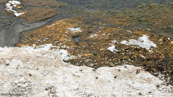
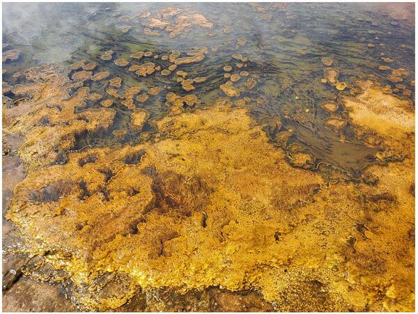
The Pinehaven Basalt, which erupted in Henrys Fork Caldera, southeast Idaho, about 35,000 years ago. Photo by Brandi Lawler, University of Wyoming, August 6, 2018.
Images
Volcano Science Center images.
The Pinehaven Basalt, which erupted in Henrys Fork Caldera, southeast Idaho, about 35,000 years ago. Photo by Brandi Lawler, University of Wyoming, August 6, 2018.
100 Spring Plain in Norris Geyser Basin, Yellowstone National Park
100 Spring Plain in Norris Geyser Basin, Yellowstone National Park100 Spring Plain in Norris Geyser Basin, Yellowstone National Park. The area is frequently flooded and impassable. Photo taken by Lauren Harrison in August 2018.
100 Spring Plain in Norris Geyser Basin, Yellowstone National Park
100 Spring Plain in Norris Geyser Basin, Yellowstone National Park100 Spring Plain in Norris Geyser Basin, Yellowstone National Park. The area is frequently flooded and impassable. Photo taken by Lauren Harrison in August 2018.
River Styx, Mammoth Hot Springs, Yellowstone National Park
River Styx, Mammoth Hot Springs, Yellowstone National ParkRiver Styx, Mammoth Hot Springs, Yellowstone National Park. This thermal feature is actually a subterranean hot water creek that likely collects water discharged from Mammoth Hot Spring pools that, after cooling and outflowing from vents, tends to disappear back underground through the porous travertine.
Lower Geyser Basin, with Fountain and Clepsydra Geysers in eruption
Lower Geyser Basin, with Fountain and Clepsydra Geysers in eruptionView of Lower Geyser Basin, with Fountain and Clepsydra Geysers in eruption, looking south towards Fountain Paint Pots. The vegetation in the photo is indicative of vegetation throughout much of Lower Geyser Basin—open grassland maintained by hot ground with patches of lodgepole pine.
Looking west over The Gap subbasin of Norris Geyser Basin, Yellowstone National Park
Looking west over The Gap subbasin of Norris Geyser Basin, Yellowstone National ParkLooking west over The Gap subbasin of Norris Geyser Basin, Yellowstone National Park, from a vantage point on the Ragged Hills. The mountain in the distance is Mt. Holmes. Photo taken in June 2018 by Lauren Harrison.
Ed Brown (identified by white arrow) pictured with his HVO colleagues during the 2018 Kīlauea eruption
Ed Brown (identified by white arrow) pictured with his HVO colleagues during the 2018 Kīlauea eruptionEd Brown (identified by white arrow, standing behind former USGS HVO Scientist-in-Charge Tina Neal) pictured with his HVO colleagues during the 2018 Kīlauea lower East Rift Zone eruption and summit collapse when HVO staff were temporarily based at the University of Hawaiʻi at Hilo Geology Department following the evacuation of the HVO building in Hawaiʻi Volcano
Map showing volcanoes that formed at the leading edge of the Yellowstone hotspot in the past several million years
Map showing volcanoes that formed at the leading edge of the Yellowstone hotspot in the past several million yearsMap showing volcanoes that formed at the leading edge of the Yellowstone hotspot in the past several million years. (A) Map of northwest Wyoming, eastern Idaho, and southern Montana (modified from Brueseke et al., 2017, https://doi.org/10.1130/GES01553.1). Upper Wind River Basin (UWRB) is depicted by dashe
Grant Village boat dock, on the West Thumb of Yellowstone Lake, where a water-level sensor measures lake level
Grant Village boat dock, on the West Thumb of Yellowstone Lake, where a water-level sensor measures lake levelGrant Village boat dock, on the West Thumb of Yellowstone Lake, where a water-level sensor measures the level of the lake. Photo by David Mencin (EarthScope Consortium).
Deformation near South Sister from GPS data, 2001-2017
Deformation near South Sister from GPS data, 2001-2017Horizontal displacements from campaign (black vectors) and continuous (red vectors, with station names given) GPS stations, as well as vertical displacements (indicated by color of GPS station symbol) near South Sister, Oregon. Length of arrow gives amount of horizontal displacement, with scale in lower left showing an arrow length
Roadcut exposure of Huckleberry Ridge Tuff and Mesa Falls Tuff along U.S. Route 20 between Ashton and Island Park, Idaho
Roadcut exposure of Huckleberry Ridge Tuff and Mesa Falls Tuff along U.S. Route 20 between Ashton and Island Park, IdahoPhotograph showing roadcut exposure of Huckleberry Ridge Tuff and Mesa Falls Tuff along U.S. Route 20 between Ashton and Island Park, Idaho. This exposure is approximately 60 feet high.
Time series of vertical displacements during April–October 2017 at four GPS stations on the north side of Yellowstone Lake
Time series of vertical displacements during April–October 2017 at four GPS stations on the north side of Yellowstone LakeTime series of vertical displacements during April–October 2017 at four GPS stations (LAK1, LAK2, LKWY, and SEDG) on the north side of Yellowstone Lake. Downward trends indicate subsidence and upward trends show uplift. Uplift “spikes” in late September are related to inclement weather and do not show true deformation. Error bars are one standard deviation.
Field crew setting up a magnetotelluric site in Yellowstone National Park
Field crew setting up a magnetotelluric site in Yellowstone National ParkField crew from Oregon State University and University of Wisconsin-Madison install a magnetotelluric site within Yellowstone National Park.
Field crew setting up a magnetotelluric site in Yellowstone National Park
Field crew setting up a magnetotelluric site in Yellowstone National ParkField crew from Oregon State University and University of Wisconsin-Madison install a magnetotelluric site within Yellowstone National Park.
Head of an immature wetsalts tiger beetle at the entrance to the burrow it dug
Head of an immature wetsalts tiger beetle at the entrance to the burrow it dugThe head of an immature wetsalts tiger beetle at the entrance to the burrow it dug. Photo by Robert K. D. Peterson, 2017.
Head of an immature wetsalts tiger beetle at the entrance to the burrow it dug
Head of an immature wetsalts tiger beetle at the entrance to the burrow it dugThe head of an immature wetsalts tiger beetle at the entrance to the burrow it dug. Photo by Robert K. D. Peterson, 2017.
WorldView-2 satellite image showing thermal areas on the north side of Mallard Lake resurgent dome in Yellowstone National Park.
WorldView-2 satellite image showing thermal areas on the north side of Mallard Lake resurgent dome in Yellowstone National Park.WorldView-2 natural-color satellite image from December 9, 2017, showing thermal areas as snow-free zones on the north side of Mallard Lake resurgent dome in Yellowstone National Park.
A blue glow is emitted by radiation during operation of the USGS TRIGA Reactor, Denver, CO
A blue glow is emitted by radiation during operation of the USGS TRIGA Reactor, Denver, COA blue glow is emitted by radiation during operation of the USGS TRIGA® Reactor, a low-power nuclear research reactor in Denver, Colorado. Photo by Christopher Farwell, October 27, 2017.
Weir on a tributary flowing into Boundary Creek in southwest Yellowstone National Park
Weir on a tributary flowing into Boundary Creek in southwest Yellowstone National ParkA weir constructed by Irving Friedman and Dan Norton to measure water discharge and to monitor changes in hydrothermal activity on a tributary flowing into Boundary Creek in southwest Yellowstone National Park. USGS photo by Shaul Hurwitz, September 17, 2017.
Focal mechanism determined by moment tensor analysis on an M4.4 event in Yellowstone National Park in 2017
Focal mechanism determined by moment tensor analysis on an M4.4 event in Yellowstone National Park in 2017Focal mechanism determined by moment tensor analysis, which uses a model to fit the long-period (~10 s period or greater) ground motion records recorded at multiple locations.
A newly emerged adult wetsalts tiger beetle. Photo by Robert K. D. Peterson, 2017.
A geologist examples a basaltic lava flow along the Madison River
A geologist examples a basaltic lava flow along the Madison RiverA geologist examples a basaltic lava flow along the Madison River, looking for an area that can yield samples suitable for 40Ar/39Ar geochronology. USGS photo by Jorge Vazquez, June 2017.
Big Southern Butte, a rhyolite dome located in the eastern Snake River Plain of Idaho
Big Southern Butte, a rhyolite dome located in the eastern Snake River Plain of IdahoBig Southern Butte, a rhyolite dome located in the eastern Snake River Plain of Idaho. Photo by Devin Englestead, BLM (https://flic.kr/p/VYMDKz).
Panoramic photo of the West Yellowstone rhyolite lava flow
Panoramic photo of the West Yellowstone rhyolite lava flowPanoramic of the West Yellowstone rhyolite lava flow taken along Highway 20 (between the West entrance of Yellowstone National Park and Madison Junction). The flow is approximately 111,000 years old and has a volume of about 41 km3 (10 mi3).