
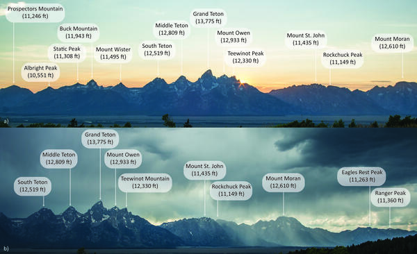
Images of a) the southern Teton Mountains and b) the northern Teton Mountains as seen from the Bridger-Teton National Forest. USGS photos by Stanley Mordensky, August 2014.
Images
Volcano Science Center images.
Filter Total Items: 563
Teton Range, Wyoming
Images of a) the southern Teton Mountains and b) the northern Teton Mountains as seen from the Bridger-Teton National Forest. USGS photos by Stanley Mordensky, August 2014.

Photo of the Old Faithful Inn lobby
Photo of the Old Faithful Inn lobby, which features a six-story-tall fireplace and chimney made from rocks quarried form a rhyolite lava flow in Yellowstone. NPS photo by Jim Peaco, July 22, 2013.
Photo of the Old Faithful Inn lobby, which features a six-story-tall fireplace and chimney made from rocks quarried form a rhyolite lava flow in Yellowstone. NPS photo by Jim Peaco, July 22, 2013.
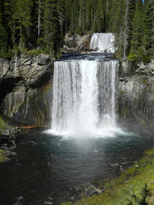
Colonnade Falls on the Bechler River, Yellowstone National Park
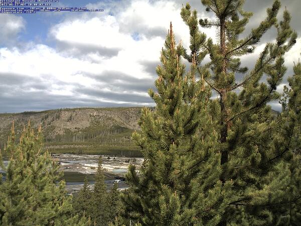
Image of Biscuit Basin (visible between the trees) captured by the YVO mobile webcam on June 17, 2012
Image of Biscuit Basin (visible between the trees) captured by the YVO mobile webcam on June 17, 2012Image of Biscuit Basin (visible between the trees) captured by the YVO mobile webcam on June 17, 2012, when it was positioned on a hill just east of the basin.

View north along U.S. Route 20 from near Ashton, ID, at the margin of the Huckleberry Ridge Tuff in the distance
View north along U.S. Route 20 from near Ashton, ID, at the margin of the Huckleberry Ridge Tuff in the distanceGoogle maps photo taken just north of Ashton, ID, along U.S. Route 20. The photo was taken looking north towards Island Park, ID. The forested ridge in the distance marks the margin of a caldera that formed 2.08 million years ago, when the Huckleberry Ridge Tuff erupted.
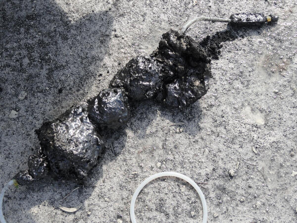
Sulfur “cinder” from Cinder Pool in Norris Geyser Basin, Yellowstone National Park
Sulfur “cinder” from Cinder Pool in Norris Geyser Basin, Yellowstone National ParkSulfur “cinder” attached to a sampling tube that was extracted from Cinder Pool in Norris Geyser Basin. The “cinder” is sulfur that existed as a molten layer at the bottom of the pool and was carried upward by gas and solidified. The black color is due to the presence of finely dispersed pyrite.
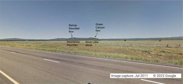
Looking west from the intersection of U.S. Route 20 and Old Hwy 47, in Idaho, at lava flows associated with the Henrys Fork caldera
Looking west from the intersection of U.S. Route 20 and Old Hwy 47, in Idaho, at lava flows associated with the Henrys Fork calderaGoogle Maps photo taken at the intersection of U.S. Route 20 and Old Hwy 47 in Idaho, looking west. The tops of Moonshine Mountain and Silver Lake dome, rhyolite lava flows located inside the caldera, are indicated with a dashed black line.
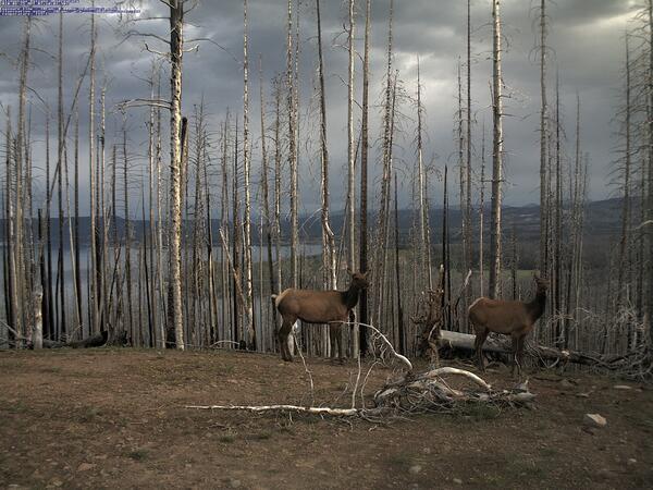
Image of elk captured by the YVO mobile webcam on June 25, 2010
Image of elk captured by the YVO mobile webcam on June 25, 2010Image of elk captured by the YVO mobile webcam on June 25, 2010, when it was positioned atop Lake Butte with a view of the north side of Yellowstone Lake.
Image of elk captured by the YVO mobile webcam on June 25, 2010
Image of elk captured by the YVO mobile webcam on June 25, 2010Image of elk captured by the YVO mobile webcam on June 25, 2010, when it was positioned atop Lake Butte with a view of the north side of Yellowstone Lake.

Overview of central West Thumb Geyser Basin
Overview of central West Thumb Geyser Basin. USGS photo by Pat Shanks, 2009.
Overview of central West Thumb Geyser Basin. USGS photo by Pat Shanks, 2009.

Photo of the Madison Museum, Yellowstone National Park
Photo of the Madison Museum, Yellowstone National ParkPhoto of the Madison Museum, built in 1930 and designed by Herbert Maier. This structure exemplifies the National Park Rustic style, using natural materials and artisan craftmanship that are intended to blend buildings into the surrounding environment, “suggesting the smallness of man in relation to nature” (Herbert Maier).

Bob Fournier measuring the gas-to-water ratio (gas/steam) at drill site Y2 in Yellowstone National Park
Bob Fournier measuring the gas-to-water ratio (gas/steam) at drill site Y2 in Yellowstone National ParkBob Fournier measuring the gas-to-water ratio (gas/steam) at drill site Y2, near Hot Lake on Firehole Lake Drive in Lower Geyser Basin, Yellowstone National Park, in the late 1960s. USGS Photo.

Yellowstone caldera viewed from Mount Washburn
Yellowstone caldera viewed from Mount Washburn. The caldera is the low-lying area extending from the foothills of Mount Washburn in the foreground to the rugged mountains on the horizon. The incised valley of the Yellowstone River stretches from left to right in the middle distance. Steep valley walls are illuminated by sunlight in the center. 
Yellowstone caldera viewed from Mount Washburn. The caldera is the low-lying area extending from the foothills of Mount Washburn in the foreground to the rugged mountains on the horizon. The incised valley of the Yellowstone River stretches from left to right in the middle distance. Steep valley walls are illuminated by sunlight in the center. 

Schematic illustration of waterfall formation
Schematic illustration of waterfall formation in which a hard rock that is more resistant to erosion is atop a softer rock that is less resistant to erosion. Source: Wikimedia (https://commons.wikimedia.org/wiki/File:WaterfallCreationDiagram.svg).
Schematic illustration of waterfall formation in which a hard rock that is more resistant to erosion is atop a softer rock that is less resistant to erosion. Source: Wikimedia (https://commons.wikimedia.org/wiki/File:WaterfallCreationDiagram.svg).

Terrace Springs, northeast of Madison Junction, Yellowstone National Park
Terrace Springs, northeast of Madison Junction, Yellowstone National ParkThe water at Terrace Springs, northeast of Madison Junction in Yellowstone National Park, is relatively cold (about 60 °C or 140 °F), but the water is still saturated with CO2-rich bubbles. Photo by Shaul Hurwitz in September 2008.
Sulfur flow at Brimstone Basin, Yellowstone National Park
Sulfur flow at Brimstone Basin, Yellowstone National ParkA sulfur flow over acid-sulfate ground at Brimstone Basin near the eastern shore of Yellowstone Lake. The flows formed when native sulfur deposits were ignited during a forest fire. Photo by Shaul Hurwitz, September 2008.

Roadcut in the Lava Creek Tuff near Tuff Cliff, Yellowstone National Park
Roadcut in the Lava Creek Tuff near Tuff Cliff, Yellowstone National ParkRoadcut in light pink ash-flow deposits of the Lava Creek Tuff on Grand Loop Road near Tuff Cliff. The color and closely spaced jointing are characteristic of the Lava Creek Tuff map unit. The steep faces and dense nature of the roadcut exposures indicate that a moderate degree of welding occurred and has not been subsequently modified by hydrothermal al

Lower Falls and Grand Canyon of the Yellowstone River
Lower Falls and Grand Canyon of the Yellowstone RiverLower Falls and Grand Canyon of the Yellowstone River. The river here is eroding young, post-caldera rhyolite that was softened by hydrothermal alteration. The V shape of the canyon indicates that the river is actively eroding in response to regional uplift. Photo by Richard Tollo, George Washington University, August 12, 2008.
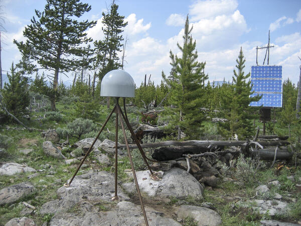
GPS station P714 in Panther Meadow, Yellowstone National Park
GPS station P714 in Panther Meadow, Yellowstone National ParkGPS station P714, located in Panther Meadow south of Mammoth Hot Springs in Yellowstone National Park. Photo by EarthScope Consortium, June 2008.
GPS station P714 in Panther Meadow, Yellowstone National Park
GPS station P714 in Panther Meadow, Yellowstone National ParkGPS station P714, located in Panther Meadow south of Mammoth Hot Springs in Yellowstone National Park. Photo by EarthScope Consortium, June 2008.

Strike-slip earthquake focal mechanism
Left hand plot shows a focal mechanism from an earthquake where the fault is horizontal (red line), and the motion is right-lateral strike skip. The initial direction of wave motion (either back toward the source or away from the source is shown by the arrows. Right hand plot shows the associated beachball diagram, with compressional (“C”) and tensional
Left hand plot shows a focal mechanism from an earthquake where the fault is horizontal (red line), and the motion is right-lateral strike skip. The initial direction of wave motion (either back toward the source or away from the source is shown by the arrows. Right hand plot shows the associated beachball diagram, with compressional (“C”) and tensional

Southern tip of the Lemhi Range, eastern Snake River Plain. showing the wall of the Blue Creek caldera
Southern tip of the Lemhi Range, eastern Snake River Plain. showing the wall of the Blue Creek calderaSouthern tip of the Lemhi Range on the northeastern margin of the eastern Snake River Plain showing the caldera wall of the 6.27 million year old Blue Creek caldera, in the Heise volcanic field. Also shown are other units from the Heise volcanic field including the Kilgore Tuff and the Blacktail Creek Tuff. In the foreground is the much thicker sequence

Eruption of Daisy Geyser, Yellowstone National Park
Eruption of Daisy Geyser, Yellowstone National ParkAn eruption of Daisy Geyser in the Upper Geyser Basin of Yellowstone National Park. The geyser erupts boiling water at about 93 °C (200 °F). Photo by Shaul Hurwitz on April 12, 2007.
Eruption of Daisy Geyser, Yellowstone National Park
Eruption of Daisy Geyser, Yellowstone National ParkAn eruption of Daisy Geyser in the Upper Geyser Basin of Yellowstone National Park. The geyser erupts boiling water at about 93 °C (200 °F). Photo by Shaul Hurwitz on April 12, 2007.