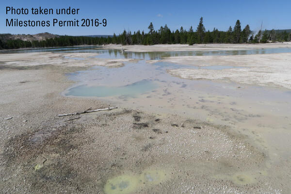
Mushroom Pool, Lower Geyser Basin, Yellowstone National Park
Mushroom Pool, Lower Geyser Basin, Yellowstone National ParkMushroom Pool, Lower Geyser Basin, Yellowstone National Park.

Official websites use .gov
A .gov website belongs to an official government organization in the United States.
Secure .gov websites use HTTPS
A lock () or https:// means you’ve safely connected to the .gov website. Share sensitive information only on official, secure websites.
Volcano Science Center images.

Mushroom Pool, Lower Geyser Basin, Yellowstone National Park.
Mushroom Pool, Lower Geyser Basin, Yellowstone National Park.
100 Spring Plain in Norris Geyser Basin, Yellowstone National Park. The area is frequently flooded and impassable. Photo taken by Lauren Harrison in August 2018.
100 Spring Plain in Norris Geyser Basin, Yellowstone National Park. The area is frequently flooded and impassable. Photo taken by Lauren Harrison in August 2018.
The Pinehaven Basalt, which erupted in Henrys Fork Caldera, southeast Idaho, about 35,000 years ago. Photo by Brandi Lawler, University of Wyoming, August 6, 2018.
The Pinehaven Basalt, which erupted in Henrys Fork Caldera, southeast Idaho, about 35,000 years ago. Photo by Brandi Lawler, University of Wyoming, August 6, 2018.
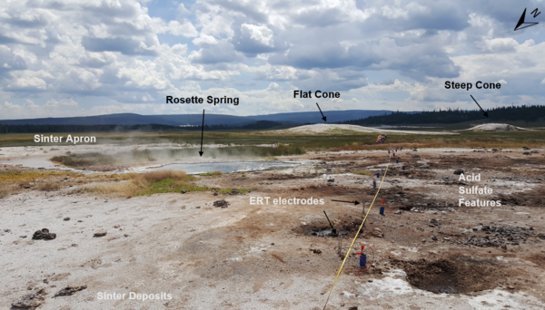
Electrical Resistivity Tomography (ERT) line R3 during setup of ERT and induced polarization measurement near Rosette Spring, Lower Geyser Basin. Photo by University of Wyoming Geophysics Team, July 17, 2018.
Electrical Resistivity Tomography (ERT) line R3 during setup of ERT and induced polarization measurement near Rosette Spring, Lower Geyser Basin. Photo by University of Wyoming Geophysics Team, July 17, 2018.

River Styx, Mammoth Hot Springs, Yellowstone National Park. This thermal feature is actually a subterranean hot water creek that likely collects water discharged from Mammoth Hot Spring pools that, after cooling and outflowing from vents, tends to disappear back underground through the porous travertine.
River Styx, Mammoth Hot Springs, Yellowstone National Park. This thermal feature is actually a subterranean hot water creek that likely collects water discharged from Mammoth Hot Spring pools that, after cooling and outflowing from vents, tends to disappear back underground through the porous travertine.

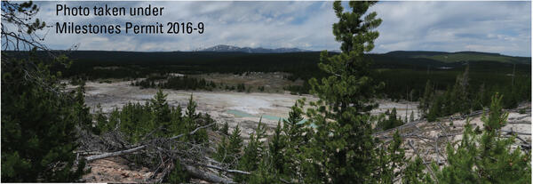
View of Lower Geyser Basin, with Fountain and Clepsydra Geysers in eruption, looking south towards Fountain Paint Pots. The vegetation in the photo is indicative of vegetation throughout much of Lower Geyser Basin—open grassland maintained by hot ground with patches of lodgepole pine.
View of Lower Geyser Basin, with Fountain and Clepsydra Geysers in eruption, looking south towards Fountain Paint Pots. The vegetation in the photo is indicative of vegetation throughout much of Lower Geyser Basin—open grassland maintained by hot ground with patches of lodgepole pine.

Ed Brown (identified by white arrow, standing behind former USGS HVO Scientist-in-Charge Tina Neal) pictured with his HVO colleagues during the 2018 Kīlauea lower East Rift Zone eruption and summit collapse when HVO staff were temporarily based at the University of Hawaiʻi at Hilo Geology Department following the evacuation of the HVO building in Hawaiʻi Volcano
Ed Brown (identified by white arrow, standing behind former USGS HVO Scientist-in-Charge Tina Neal) pictured with his HVO colleagues during the 2018 Kīlauea lower East Rift Zone eruption and summit collapse when HVO staff were temporarily based at the University of Hawaiʻi at Hilo Geology Department following the evacuation of the HVO building in Hawaiʻi Volcano
Looking west over The Gap subbasin of Norris Geyser Basin, Yellowstone National Park, from a vantage point on the Ragged Hills. The mountain in the distance is Mt. Holmes. Photo taken in June 2018 by Lauren Harrison.
Looking west over The Gap subbasin of Norris Geyser Basin, Yellowstone National Park, from a vantage point on the Ragged Hills. The mountain in the distance is Mt. Holmes. Photo taken in June 2018 by Lauren Harrison.
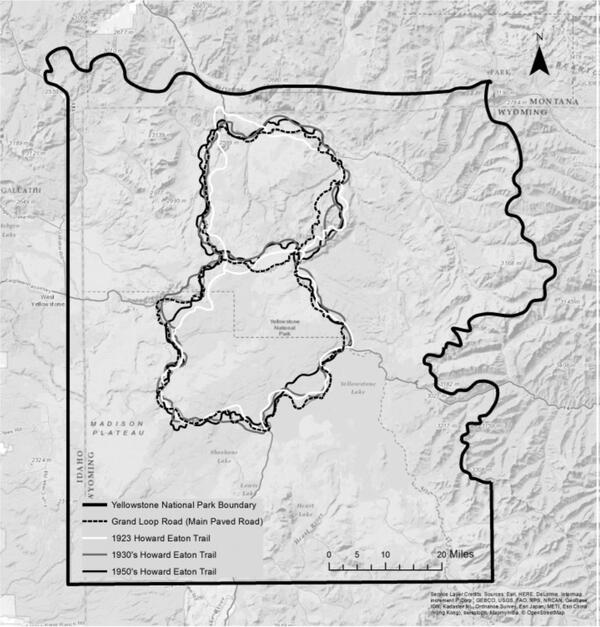
This map shows the Grand Loop Road along with different versions of the Howard Eaton Trail. Over the years, sections of the trail were rerouted to improve visitor safety, reduce maintenance costs, and protect sensitive natural areas. Using National Park Service and USGS sources from 1923, 1937, 1956, 1958, and 1959, students E.
This map shows the Grand Loop Road along with different versions of the Howard Eaton Trail. Over the years, sections of the trail were rerouted to improve visitor safety, reduce maintenance costs, and protect sensitive natural areas. Using National Park Service and USGS sources from 1923, 1937, 1956, 1958, and 1959, students E.

Time series of vertical displacements during April–October 2017 at four GPS stations (LAK1, LAK2, LKWY, and SEDG) on the north side of Yellowstone Lake. Downward trends indicate subsidence and upward trends show uplift. Uplift “spikes” in late September are related to inclement weather and do not show true deformation. Error bars are one standard deviation.
Time series of vertical displacements during April–October 2017 at four GPS stations (LAK1, LAK2, LKWY, and SEDG) on the north side of Yellowstone Lake. Downward trends indicate subsidence and upward trends show uplift. Uplift “spikes” in late September are related to inclement weather and do not show true deformation. Error bars are one standard deviation.

Horizontal displacements from campaign (black vectors) and continuous (red vectors, with station names given) GPS stations, as well as vertical displacements (indicated by color of GPS station symbol) near South Sister, Oregon. Length of arrow gives amount of horizontal displacement, with scale in lower left showing an arrow length
Horizontal displacements from campaign (black vectors) and continuous (red vectors, with station names given) GPS stations, as well as vertical displacements (indicated by color of GPS station symbol) near South Sister, Oregon. Length of arrow gives amount of horizontal displacement, with scale in lower left showing an arrow length

Photograph showing roadcut exposure of Huckleberry Ridge Tuff and Mesa Falls Tuff along U.S. Route 20 between Ashton and Island Park, Idaho. This exposure is approximately 60 feet high.
Photograph showing roadcut exposure of Huckleberry Ridge Tuff and Mesa Falls Tuff along U.S. Route 20 between Ashton and Island Park, Idaho. This exposure is approximately 60 feet high.

Field crew from Oregon State University and University of Wisconsin-Madison install a magnetotelluric site within Yellowstone National Park.
Field crew from Oregon State University and University of Wisconsin-Madison install a magnetotelluric site within Yellowstone National Park.

The head of an immature wetsalts tiger beetle at the entrance to the burrow it dug. Photo by Robert K. D. Peterson, 2017.
The head of an immature wetsalts tiger beetle at the entrance to the burrow it dug. Photo by Robert K. D. Peterson, 2017.

Map showing volcanoes that formed at the leading edge of the Yellowstone hotspot in the past several million years. (A) Map of northwest Wyoming, eastern Idaho, and southern Montana (modified from Brueseke et al., 2017, https://doi.org/10.1130/GES01553.1). Upper Wind River Basin (UWRB) is depicted by dashe
Map showing volcanoes that formed at the leading edge of the Yellowstone hotspot in the past several million years. (A) Map of northwest Wyoming, eastern Idaho, and southern Montana (modified from Brueseke et al., 2017, https://doi.org/10.1130/GES01553.1). Upper Wind River Basin (UWRB) is depicted by dashe

Grant Village boat dock, on the West Thumb of Yellowstone Lake, where a water-level sensor measures the level of the lake. Photo by David Mencin (EarthScope Consortium).
Grant Village boat dock, on the West Thumb of Yellowstone Lake, where a water-level sensor measures the level of the lake. Photo by David Mencin (EarthScope Consortium).

WorldView-2 natural-color satellite image from December 9, 2017, showing thermal areas as snow-free zones on the north side of Mallard Lake resurgent dome in Yellowstone National Park.
WorldView-2 natural-color satellite image from December 9, 2017, showing thermal areas as snow-free zones on the north side of Mallard Lake resurgent dome in Yellowstone National Park.

A blue glow is emitted by radiation during operation of the USGS TRIGA® Reactor, a low-power nuclear research reactor in Denver, Colorado. Photo by Christopher Farwell, October 27, 2017.
A blue glow is emitted by radiation during operation of the USGS TRIGA® Reactor, a low-power nuclear research reactor in Denver, Colorado. Photo by Christopher Farwell, October 27, 2017.
Echinus Geyser in eruption on October 24, 2017. Photo by MA Bellingham, used with permission.
Echinus Geyser in eruption on October 24, 2017. Photo by MA Bellingham, used with permission.

A weir constructed by Irving Friedman and Dan Norton to measure water discharge and to monitor changes in hydrothermal activity on a tributary flowing into Boundary Creek in southwest Yellowstone National Park. USGS photo by Shaul Hurwitz, September 17, 2017.
A weir constructed by Irving Friedman and Dan Norton to measure water discharge and to monitor changes in hydrothermal activity on a tributary flowing into Boundary Creek in southwest Yellowstone National Park. USGS photo by Shaul Hurwitz, September 17, 2017.

Focal mechanism determined by moment tensor analysis, which uses a model to fit the long-period (~10 s period or greater) ground motion records recorded at multiple locations.
Focal mechanism determined by moment tensor analysis, which uses a model to fit the long-period (~10 s period or greater) ground motion records recorded at multiple locations.