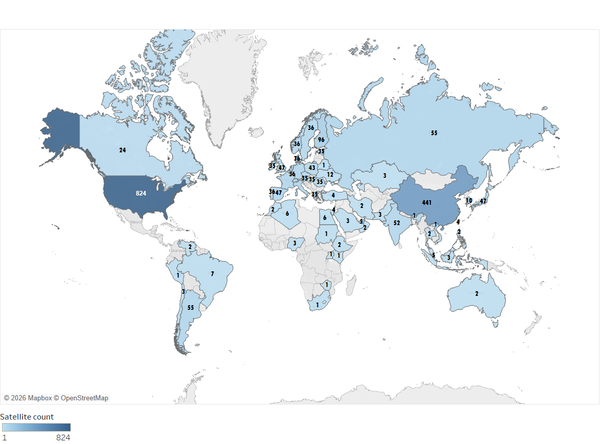
The numbers on this map indicate the number of commercial and government/civil Earth observing satellites launched by the highlighted countries. This image is updated quarterly.
Visit the Earth Observing Satellites webpage to learn more.

Official websites use .gov
A .gov website belongs to an official government organization in the United States.
Secure .gov websites use HTTPS
A lock () or https:// means you’ve safely connected to the .gov website. Share sensitive information only on official, secure websites.
The numbers on this map indicate the number of commercial and government/civil Earth observing satellites launched by the highlighted countries. This image is updated quarterly.
Visit the Earth Observing Satellites webpage to learn more.
The numbers on this map indicate the number of commercial and government/civil Earth observing satellites launched by the highlighted countries. This image is updated quarterly.
Visit the Earth Observing Satellites webpage to learn more.
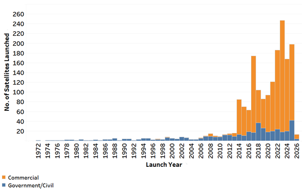
This chart shows the number of commercial and government/civil satellites launched each year since 1972. This information is updated quarterly.
Visit the Earth Observing Satellites webpage to learn more.
This chart shows the number of commercial and government/civil satellites launched each year since 1972. This information is updated quarterly.
Visit the Earth Observing Satellites webpage to learn more.
In a September 21, 1966 press release, Secretary of the Interior Stewart Udall announced that the DOI was launching "Project EROS (Earth Resources Observation Satellites)." Udall's vision was to observe the Earth for the benefit of all.
In a September 21, 1966 press release, Secretary of the Interior Stewart Udall announced that the DOI was launching "Project EROS (Earth Resources Observation Satellites)." Udall's vision was to observe the Earth for the benefit of all.

JACIE 2026 Workshop Save the Date
Visit the JACIE 2026 Workshop webpage to keep up with information about the April 2026 meeting.
JACIE 2026 Workshop Save the Date
Visit the JACIE 2026 Workshop webpage to keep up with information about the April 2026 meeting.

This image shows the spectral bandpasses for the sensors on all Landsat satellites.
This image shows the spectral bandpasses for the sensors on all Landsat satellites.

This picture is the site of the Big Multi-Agency Campaign (BigMAC), a comprehensive field exercise aimed at assessing current technologies that might be used for validation of surface products derived from satellite imagery, The exercise was held in Brookings, South Dakota in August 2021.
This picture is the site of the Big Multi-Agency Campaign (BigMAC), a comprehensive field exercise aimed at assessing current technologies that might be used for validation of surface products derived from satellite imagery, The exercise was held in Brookings, South Dakota in August 2021.

Calibration and validation (cal/val) are essential steps to ensure that remotely sensed data are reliable for scientific use. Radiometric cal/val involves converting digital image pixel values to meaningful units and assessing their accuracy.
Calibration and validation (cal/val) are essential steps to ensure that remotely sensed data are reliable for scientific use. Radiometric cal/val involves converting digital image pixel values to meaningful units and assessing their accuracy.

In a remote part of the Sahara Desert in Egypt, center pivot irrigation fields fill the landscape. Thanks to the Landsat archive, we can see how dramatically this area has changed over the last 35 years. But until the growth in irrigation, this part of the world hadn't changed much from a satellite's perspective.
In a remote part of the Sahara Desert in Egypt, center pivot irrigation fields fill the landscape. Thanks to the Landsat archive, we can see how dramatically this area has changed over the last 35 years. But until the growth in irrigation, this part of the world hadn't changed much from a satellite's perspective.

Engineers and scientists from both Landsat and Sentinel missions are working together to calibrate observation data and validate its quality to improve the science using these resources.
Engineers and scientists from both Landsat and Sentinel missions are working together to calibrate observation data and validate its quality to improve the science using these resources.

On board Landsat 8 are two sensors that capture data about earth's surface. Here is an explanation of the instruments that capture every pixel.
On board Landsat 8 are two sensors that capture data about earth's surface. Here is an explanation of the instruments that capture every pixel.

Once the ground stations receive data from Landsat, there's still a lot of processing to make every pixel usable. Here's an overview of some of that work.
Once the ground stations receive data from Landsat, there's still a lot of processing to make every pixel usable. Here's an overview of some of that work.
When the first Landsat satellite launched 50 years ago, it was the only game in town in terms of civilian land remote sensing. In the years that followed, a host of satellites have launched to serve similar purposes. But that data doesn't always play well together.
When the first Landsat satellite launched 50 years ago, it was the only game in town in terms of civilian land remote sensing. In the years that followed, a host of satellites have launched to serve similar purposes. But that data doesn't always play well together.
Calibration teams at the USGS EROS Center use a variety of methods to make sure the data collected by Landsat satellites are an accurate representation of the Earth’s surface.
Calibration teams at the USGS EROS Center use a variety of methods to make sure the data collected by Landsat satellites are an accurate representation of the Earth’s surface.
Earth observation used to be the province of a handful of countries with satellite technology. Today, hundreds of satellites built all over the world are launched every year. This episode of Eyes on Earth talks about the explosive growth in the civilian and commercial remote sensing and EROS’ role in it.
Earth observation used to be the province of a handful of countries with satellite technology. Today, hundreds of satellites built all over the world are launched every year. This episode of Eyes on Earth talks about the explosive growth in the civilian and commercial remote sensing and EROS’ role in it.


