
This image shows the spectral bandpasses for the sensors on all Landsat satellites.
Landsat 4
Landsat 4
Explore research, stories, and images featuring the satellite
Explore research, stories, and images featuring the satellite
Landsat 4 was launched with the Multispectral Scanner (MSS) and a new advanced imaging sensor, Thematic Mapper (TM), allowing for clearer views of natural disasters from space.
Media

Sources/Usage: Public Domain. View Media Details
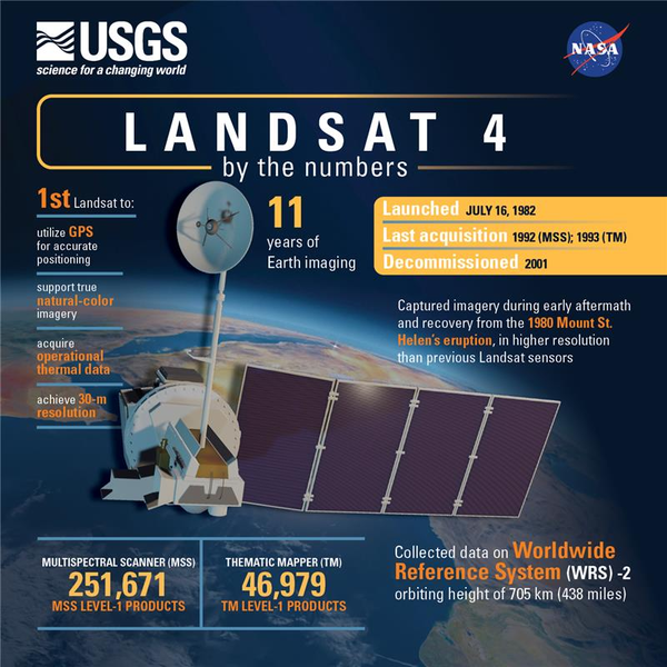
Landsat 4 was launched from Vandenberg Air Force Base in California on July 16, 1982 on a Delta 3920 rocket. The sensors onboard the satellite collected data until late 1993, and the satellite was decommissioned on June 15, 2001. Landsat 4 was built and launched by NASA. NOAA initially oversaw the operations of the satellite but was eventually contracted out to the Earth Observation Satellite Company (EOSAT) in 1984. Despite numerous operations transfers, USGS EROS has remained responsible for the record and data keeping of the Landsat program.
Although the satellite was set in a lower orbit than Landsat 1-3, it had a higher field of view to retain the same swath width as its predecessors of 185 km (115 mi). The lower altitude results in a different swathing pattern.
With an updated design from the previous three missions, the satellite carried the MSS as well as the new TM instruments. It did not carry the Return Beam Vidicon (RBV) sensor.
Landsat 4 Satellite Orbit Facts
Media
Sources/Usage: Public Domain. View Media Details
- Orbited the Earth in a sun-synchronous, near-polar orbit (98.2 degrees inclination)
- Reached an altitude of 705 km (438 mi)
- Circled the Earth every 99 minutes
- Had a 16-day repeat cycle with an equatorial crossing time of 9:45 a.m. +/- 15 minutes.
- Acquired on the Worldwide Reference System-2 (WRS-2) path/row system, with swath overlap (or sidelap) varying from 7 percent at the Equator to a maximum of approximately 85 percent at extreme latitudes.
Landsat 4 Instruments
Landsat 4 carried the Multispectral Scanner (MSS) and the new Thematic Mapper (TM) sensors.
Multispectral Scanner (MSS)
Four spectral bands (identical to Landsat 1 and 2):
- Four spectral bands:
- Band 1 Visible Green (0.5 to 0.6 µm)
- Band 2 Visible Red(0.6 to 0.7 µm)
- Band 3 Near-Infrared (0.7 to 0.8 µm)
- Band 4 Near-Infrared (0.8 to 1.1 µm)
- Data: 100 kHz digital
- Six detectors for each reflective band provided six scan lines on each active scan
- Ground Sampling Interval (pixel size): 57 x 79 m
- Swath width: 185 km (115 miles)
Visit Landsat 1-5 MSS for more information.
Thematic Mapper (TM)
The TM's improved spectral and spatial resolution allowed the instrument to see the ground in greater detail and included a thermal band.
- Added the mid-range infrared to the data
- Seven spectral bands, including a thermal band:
- Band 1 Visible Blue (0.45 - 0.52 µm) 30 m
- Band 2 Visible Green (0.52 - 0.60 µm) 30 m
- Band 3 Visible Red (0.63 - 0.69 µm) 30 m
- Band 4 Near-Infrared (0.76 - 0.90 µm) 30 m
- Band 5 Near-Infrared (1.55 - 1.75 µm) 30 m
- Band 6 Thermal (10.40 - 12.50 µm) 120 m
- Band 7 Mid-Infrared (IR) (2.08 - 2.35 µm) 30 m
- Ground Sampling Interval (pixel size): 30 m reflective, 120 m thermal
- Swath width: 185 km (115 miles)
Visit Landsat 4-5 TM for more information.
Landsat 4 Spacecraft Facts
- Manufactured by GE Astro Space, Fairchild
- Weight: approximately 1,941kg (4,279 lbs)
- 3-axis stabilized, zero momentum with control of 0.01º, using reaction wheels
- Single solar array with 1-axis articulation produces 1430 W
- Two NiCd batteries provide 100 Ah total power
- S-Band and Very High Frequency (VHF) communications
- Hydrazine propulsion system
Additional Resources
Landsat 4 History (NASA Landsat Science)
The Multispectral Scanner (NASA Landsat Science)
The Thematic Mapper (NASA Landsat Science)
Related
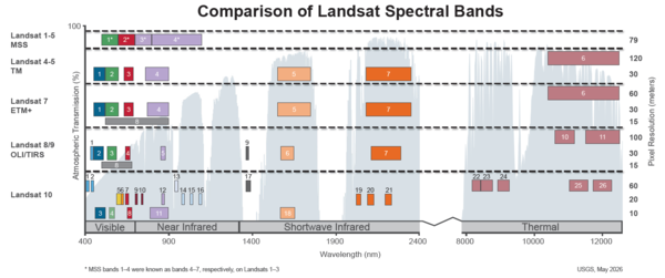
Spectral Bandpasses for all Landsat Sensors
This image shows the spectral bandpasses for the sensors on all Landsat satellites.
")
Landsat: Celebrating 50 Years (Extended Edition)
50 years of teamwork. 50 years of innovation. 50 years of resilience. In 1966, Secretary of the Interior Stewart Udall announced his vision to create a program aimed at gathering facts about the natural resources of the Earth from Earth orbiting satellites. It was a bold proclamation. It was also an idea that worked and continues to work 50 years on.
50 years of teamwork. 50 years of innovation. 50 years of resilience. In 1966, Secretary of the Interior Stewart Udall announced his vision to create a program aimed at gathering facts about the natural resources of the Earth from Earth orbiting satellites. It was a bold proclamation. It was also an idea that worked and continues to work 50 years on.
Landsat: Celebrating 50 Years
The Landsat program conceived of in the 1960s, has been running longer than any remote sensing program. The idea was simple: position a satellite in a nearly polar orbit fixed to the solar angle so that each daytime pass would cross the equator at roughly the same local time.
The Landsat program conceived of in the 1960s, has been running longer than any remote sensing program. The idea was simple: position a satellite in a nearly polar orbit fixed to the solar angle so that each daytime pass would cross the equator at roughly the same local time.

Example of the Landsat 4-5 TM Collection 2 level-2 science products
Example of the Landsat 4-5 TM Collection 2 level-2 science productsExample of the Landsat 4-5 TM Collection 2 level-2 science products. Left: Landsat 5 level-2 surface reflectance image. Right: Landsat 5 level-2 surface temperature image. The data was acquired on October 6, 2010 (path 47 row 27).

1982 - Landsat 4 launch 1
Landsat 4 launch.

Landsat 4 First Light Image of Detroit
The first Landsat 4 image was acquired over western Lake Erie on July 25, 1982, just 9 days after launch. This image shows the Detroit River dividing the metropolitan areas of Detroit, Michigan and Windsor, Ontario while acting as a strait between Lake Erie and Lake St. Clair.
The first Landsat 4 image was acquired over western Lake Erie on July 25, 1982, just 9 days after launch. This image shows the Detroit River dividing the metropolitan areas of Detroit, Michigan and Windsor, Ontario while acting as a strait between Lake Erie and Lake St. Clair.

Landsat 4 First Light Image over western Lake Erie
Landsat 4 First Light Image over western Lake ErieLandsat 4's first light image captured eastern Lake Erie, and the cities of Toledo, Detroit, and Windsor on July 25, 1982. Although the Landsat program had been collecting images of the Earth since 1972, this was the first time that the data could be depicted as a natural color image due to the new Thematic Mapper sensor onboard Landsat 4.

1982 - Landsat 4 launch
Landsat 4 launch. EROS History Project
Related
Spectral Bandpasses for all Landsat Sensors
This image shows the spectral bandpasses for the sensors on all Landsat satellites.
This image shows the spectral bandpasses for the sensors on all Landsat satellites.
Landsat: Celebrating 50 Years (Extended Edition)
50 years of teamwork. 50 years of innovation. 50 years of resilience. In 1966, Secretary of the Interior Stewart Udall announced his vision to create a program aimed at gathering facts about the natural resources of the Earth from Earth orbiting satellites. It was a bold proclamation. It was also an idea that worked and continues to work 50 years on.
50 years of teamwork. 50 years of innovation. 50 years of resilience. In 1966, Secretary of the Interior Stewart Udall announced his vision to create a program aimed at gathering facts about the natural resources of the Earth from Earth orbiting satellites. It was a bold proclamation. It was also an idea that worked and continues to work 50 years on.
Landsat: Celebrating 50 Years
The Landsat program conceived of in the 1960s, has been running longer than any remote sensing program. The idea was simple: position a satellite in a nearly polar orbit fixed to the solar angle so that each daytime pass would cross the equator at roughly the same local time.
The Landsat program conceived of in the 1960s, has been running longer than any remote sensing program. The idea was simple: position a satellite in a nearly polar orbit fixed to the solar angle so that each daytime pass would cross the equator at roughly the same local time.
Example of the Landsat 4-5 TM Collection 2 level-2 science products
Example of the Landsat 4-5 TM Collection 2 level-2 science productsExample of the Landsat 4-5 TM Collection 2 level-2 science products. Left: Landsat 5 level-2 surface reflectance image. Right: Landsat 5 level-2 surface temperature image. The data was acquired on October 6, 2010 (path 47 row 27).
1982 - Landsat 4 launch 1
Landsat 4 launch.
Landsat 4 First Light Image of Detroit
The first Landsat 4 image was acquired over western Lake Erie on July 25, 1982, just 9 days after launch. This image shows the Detroit River dividing the metropolitan areas of Detroit, Michigan and Windsor, Ontario while acting as a strait between Lake Erie and Lake St. Clair.
The first Landsat 4 image was acquired over western Lake Erie on July 25, 1982, just 9 days after launch. This image shows the Detroit River dividing the metropolitan areas of Detroit, Michigan and Windsor, Ontario while acting as a strait between Lake Erie and Lake St. Clair.
Landsat 4 First Light Image over western Lake Erie
Landsat 4 First Light Image over western Lake ErieLandsat 4's first light image captured eastern Lake Erie, and the cities of Toledo, Detroit, and Windsor on July 25, 1982. Although the Landsat program had been collecting images of the Earth since 1972, this was the first time that the data could be depicted as a natural color image due to the new Thematic Mapper sensor onboard Landsat 4.
1982 - Landsat 4 launch
Landsat 4 launch. EROS History Project