
Land Cover
Land Cover
Filter Total Items: 47

Biodiversity and Protected Areas in West Africa
Biological diversity, or biodiversity, can be defined as the full array of life in a region, including species richness, ecosystem complexity, and genetic variation. Biodiversity may be the greatest natural resource, as it is a source of food, fuel, medicines, clothing, building materials, clean water, tourism and many other benefits (Norse and others, 1986). Biodiversity possesses marked economic...

Ecological Regions
The map of ecological regions of West Africa captures the variety and complexity of West Africa’s landscapes and presents a way of organizing them into smaller units. Ecological regions, or ecoregions, are areas of relative homogeneity with respect to ecological systems involving the interrelationships of plants, animals, and their environment. Ecoregions are a holistic concept: The spatial...

Bioclimatic Regions Map
From north to south — from the Sahara to the humid southern coast — West Africa can be subdivided into five broad east-west belts that characterize the climate and the vegetation. These are the bioclimatic zones known as the Saharan, Sahelian, Sudanian, Guinean, and Guineo-Congolian Regions, shown in the map above. The lines between these regions represent more of a transition along a continuous...

Physical Geography
The 8 million square kilometers and 17 countries covered by this atlas encompass a wide range of landscapes from alluvial valleys in Senegal and Ghana, sandy plains and low plateaus across the Sahel, and rolling hills of Togo to rugged mountains with summits reaching over 1,500 m in Guinea and 1,800 m in Niger. Covering approximately one quarter of Africa, West Africa contains a broad range of...

Landscape Restoration and Re-greening
West Africa’s population is expected to double by 2050, increasing the demands on already limited land, water, and forest resources. The region’s landscapes are already affected by degradation, particularly in the fast growing agricultural lands where natural vegetation cover has been removed, and fragile soils have been exposed to wind and water erosion. Since 1975, West African forests have...

The Deforestation of the Upper Guinean Forest
The Upper Guinean forest of West Africa, identified over 20 years ago as a “global biodiversity hotspot” due to its exceptional concentrations of endemic species and exceptional loss of habitats, encompasses all of the lowland forests of West Africa (Mittermeier and others, 1999; Myers and others, 2000). The forest ecosystem extends from southern Guinea into eastern Sierra Leone, through Liberia...

USGS EROS Archive - LCMAP- Continuous Change Detection Classification v1.3 (CCDC) Products (U.S.)
The Land Change Monitoring, Assessment and Projection (LCMAP) project has generated an integrated suite of annual land cover and land surface change products for the United States based on time series data from the Landsat record from 1985–2021. LCMAP Collection 1.3 Science Products are based on the USGS implementation of the Continuous Change Detection and Classification (CCDC) algorithm.
USGS EROS Archive - LCMAP- Continuous Change Detection Classification v1.2 (CCDC) Products (U.S.)
The Land Change Monitoring, Assessment and Projection (LCMAP) project has generated an integrated suite of annual land cover and land surface change products for the United States based on time series data from the Landsat record from 1985–2020. LCMAP Collection 1.2 Science Products are based on the USGS implementation of the Continuous Change Detection and Classification (CCDC) algorithm.

LCMAP Change Stories: Building a Boomtown, Block by Block
The desert outpost of Palm Springs, California and the surrounding Thousand Palms region has experienced explosive population growth over the past four decades, with tract after tract of development filling in previously barren landscapes along Interstate 10.

LCMAP Change Stories: Gone in 60 Seconds
At first glance, the most striking patterns in land cover change over time in this animation of the Oso, Washington area would appear to be forest harvest and regrowth, but a more dramatic change emerged in 2014.
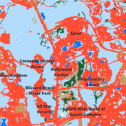
LCMAP Change Stories: It's a Sprawl World After All
The man-made Florida playland of Walt Disney World has grown outward on all sides since the amusement park’s construction commenced in the 1960s. Much of that growth has overtaken the wetlands, tree cover and grassland/shrublands near Orlando.

LCMAP Change Stories: Alabama Tornadoes
The USGS Land Change Monitoring, Assessment, and Projection initiative aims to identify where the landscape is changing and why.