
This video provides an overview of the science and products produced by the U.S. Geological Survey Woods Hole Coastal and Marine Science Center, as well as the use and value of the knowledge, data, and tools produced by the Center. It additionally highlights the Center’s location, where we conduct research, and collaborator/stakeholder types.
Coasts 101
Coasts border all bodies of water on Earth, marking the transition from land to water. They are home to over 127 million people—more than 40% of the Nation’s population and provides $8.6 trillion in goods and services each year. USGS research and tools help our Nation manage vital, healthy, and sustainable coastal areas.
Our Nation's coasts are places of beauty where memories are made. They provide homes and livelihoods for people and wildlife, where tourism, commerce, and communities depend on healthy and resilient resources. Our coasts provide services such as food resources, vital habitat for wildlife, critical protection from storms, and iconic landscapes to explore or unwind with surf and sky. Our coasts are valuable to all of us, whether it is your backyard, place of work, or somewhere you hope to visit one day.
Science for Changing Coasts
Science for Changing Coasts
Coastal Storm Modeling System (CoSMoS)
Coastal Storm Modeling System (CoSMoS)
Tools: Technical Capabilities and Applications
Tools: Technical Capabilities and Applications
Preparing for Hazards
Preparing for Hazards
Reducing Risk
Reducing Risk
Managing our Coasts for Wildlife
Managing our Coasts for Wildlife
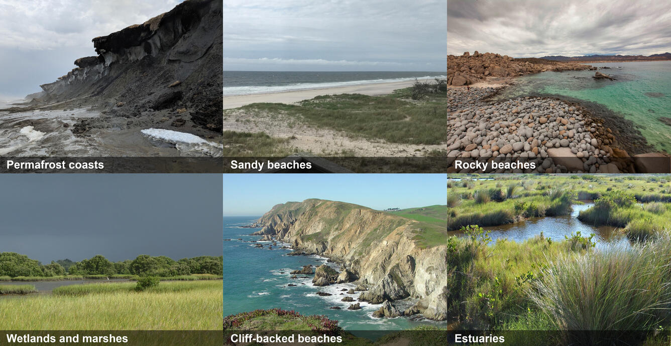
Our coasts can be sandy, rocky, lined with marshes or coral reefs, or contain other types of geologic features such as cliffs or frozen permafrost bluffs and also include coastal areas surrounding the Great Lakes. The USGS studies the geology of these various coastal areas, how they change over time, and the hazards and ecosystems associated with these changes.
Media
Sources/Usage: Public Domain. View Media Details
USGS science helps to:
-
Better understand our changing coasts, and inform strategies for our coastal communities to adapt with them
-
Analyze coastal systems and develop products that inform coastal engineering, municipal, commercial, and industrial development decisions along our ports and coastal waterways
-
Develop tools to visualize and analyze coastal change, related processes and associated hazards
-
Prepare for impacts associated with current and future coastal hazards such as extreme storms, flooding, erosion, and sea-level rise
-
Inform partners and engage with at-risk communities on the best ways to manage, protect, and restore our coastal wildlife and ecosystems
-
Provide assessments about how changes in sediment management and coastal habitats can affect wildlife like sea turtles, migratory birds and coastal fisheries in order to better manage impacts from these activities
-
Characterize where legacy mine wastes occur in offshore coastal environments so that managers and partners can decide on the best mitigation measures
Multimedia

USGS Woods Hole Coastal and Marine Science Center
This video provides an overview of the science and products produced by the U.S. Geological Survey Woods Hole Coastal and Marine Science Center, as well as the use and value of the knowledge, data, and tools produced by the Center. It additionally highlights the Center’s location, where we conduct research, and collaborator/stakeholder types.

USGS Coastal Change Hazards
The USGS Coastal Change Hazards team works to identify and address the Nation’s coastal change hazards problems. By integrating research, technical capabilities and applications, and stakeholder engagement and communications, the Coastal Change Hazards team develops robust and accessible coastal change assessments, forecasts, and tools that help improve the lives,
The USGS Coastal Change Hazards team works to identify and address the Nation’s coastal change hazards problems. By integrating research, technical capabilities and applications, and stakeholder engagement and communications, the Coastal Change Hazards team develops robust and accessible coastal change assessments, forecasts, and tools that help improve the lives,

We are the Coastal and Marine Hazards and Resources Program
We are the Coastal and Marine Hazards and Resources ProgramWe are the USGS Coastal and Marine Hazards and Resources Program. Our mission is to provide science for sustainable stewardship of Earth’s precious resources.
We are the Coastal and Marine Hazards and Resources Program
We are the Coastal and Marine Hazards and Resources ProgramWe are the USGS Coastal and Marine Hazards and Resources Program. Our mission is to provide science for sustainable stewardship of Earth’s precious resources.
Coasts, Storms, and Sea Level Rise Geonarratives
Coasts, Storms, and Sea Level Rise Geonarratives
Our Coasts Geonarrative
Our Coasts Geonarrative
USGS Woods Hole Coastal and Marine Science Center
This video provides an overview of the science and products produced by the U.S. Geological Survey Woods Hole Coastal and Marine Science Center, as well as the use and value of the knowledge, data, and tools produced by the Center. It additionally highlights the Center’s location, where we conduct research, and collaborator/stakeholder types.
This video provides an overview of the science and products produced by the U.S. Geological Survey Woods Hole Coastal and Marine Science Center, as well as the use and value of the knowledge, data, and tools produced by the Center. It additionally highlights the Center’s location, where we conduct research, and collaborator/stakeholder types.
USGS Coastal Change Hazards
The USGS Coastal Change Hazards team works to identify and address the Nation’s coastal change hazards problems. By integrating research, technical capabilities and applications, and stakeholder engagement and communications, the Coastal Change Hazards team develops robust and accessible coastal change assessments, forecasts, and tools that help improve the lives,
The USGS Coastal Change Hazards team works to identify and address the Nation’s coastal change hazards problems. By integrating research, technical capabilities and applications, and stakeholder engagement and communications, the Coastal Change Hazards team develops robust and accessible coastal change assessments, forecasts, and tools that help improve the lives,
We are the Coastal and Marine Hazards and Resources Program
We are the Coastal and Marine Hazards and Resources ProgramWe are the USGS Coastal and Marine Hazards and Resources Program. Our mission is to provide science for sustainable stewardship of Earth’s precious resources.
We are the Coastal and Marine Hazards and Resources Program
We are the Coastal and Marine Hazards and Resources ProgramWe are the USGS Coastal and Marine Hazards and Resources Program. Our mission is to provide science for sustainable stewardship of Earth’s precious resources.

How is the Landsat 8 and Landsat 9 Coastal/Aerosol Band 1 used? How is the Landsat 8 and Landsat 9 Coastal/Aerosol Band 1 used?
The Operational Land Imager Band 1 ( 0.433-0.453 µm) on Landsat 8 and Landsat 9 is useful for imaging shallow water and tracking fine atmospheric particles like dust and smoke. Band 1 reflects blues and violets, where light is scattered by dust, smoke, and water particles in the air. Collecting data with enough sensitivity at this spectrum is difficult. Since water absorbs and scatters light...

What are the official definitions of regions in the United States like "the Midwest," "the South," or the “East Coast”? What are the official definitions of regions in the United States like "the Midwest," "the South," or the “East Coast”?
The U.S. Board on Geographic Names does not define the extents of geographic regions, nor are they recorded in Geographic Names Information System (GNIS). The names and boundaries of regions are application-driven; that is, defined by a specific entity on a case-by-case basis according to a specific need, characteristics, or perception. Individuals might agree on the core of a region, but the...
Coasts border all bodies of water on Earth, marking the transition from land to water. They are home to over 127 million people—more than 40% of the Nation’s population and provides $8.6 trillion in goods and services each year. USGS research and tools help our Nation manage vital, healthy, and sustainable coastal areas.
Our Nation's coasts are places of beauty where memories are made. They provide homes and livelihoods for people and wildlife, where tourism, commerce, and communities depend on healthy and resilient resources. Our coasts provide services such as food resources, vital habitat for wildlife, critical protection from storms, and iconic landscapes to explore or unwind with surf and sky. Our coasts are valuable to all of us, whether it is your backyard, place of work, or somewhere you hope to visit one day.
Science for Changing Coasts
Science for Changing Coasts
Coastal Storm Modeling System (CoSMoS)
Coastal Storm Modeling System (CoSMoS)
Tools: Technical Capabilities and Applications
Tools: Technical Capabilities and Applications
Preparing for Hazards
Preparing for Hazards
Reducing Risk
Reducing Risk
Managing our Coasts for Wildlife
Managing our Coasts for Wildlife
Our coasts can be sandy, rocky, lined with marshes or coral reefs, or contain other types of geologic features such as cliffs or frozen permafrost bluffs and also include coastal areas surrounding the Great Lakes. The USGS studies the geology of these various coastal areas, how they change over time, and the hazards and ecosystems associated with these changes.
Media
Sources/Usage: Public Domain. View Media Details
USGS science helps to:
-
Better understand our changing coasts, and inform strategies for our coastal communities to adapt with them
-
Analyze coastal systems and develop products that inform coastal engineering, municipal, commercial, and industrial development decisions along our ports and coastal waterways
-
Develop tools to visualize and analyze coastal change, related processes and associated hazards
-
Prepare for impacts associated with current and future coastal hazards such as extreme storms, flooding, erosion, and sea-level rise
-
Inform partners and engage with at-risk communities on the best ways to manage, protect, and restore our coastal wildlife and ecosystems
-
Provide assessments about how changes in sediment management and coastal habitats can affect wildlife like sea turtles, migratory birds and coastal fisheries in order to better manage impacts from these activities
-
Characterize where legacy mine wastes occur in offshore coastal environments so that managers and partners can decide on the best mitigation measures
Multimedia
USGS Woods Hole Coastal and Marine Science Center
This video provides an overview of the science and products produced by the U.S. Geological Survey Woods Hole Coastal and Marine Science Center, as well as the use and value of the knowledge, data, and tools produced by the Center. It additionally highlights the Center’s location, where we conduct research, and collaborator/stakeholder types.
This video provides an overview of the science and products produced by the U.S. Geological Survey Woods Hole Coastal and Marine Science Center, as well as the use and value of the knowledge, data, and tools produced by the Center. It additionally highlights the Center’s location, where we conduct research, and collaborator/stakeholder types.
USGS Coastal Change Hazards
The USGS Coastal Change Hazards team works to identify and address the Nation’s coastal change hazards problems. By integrating research, technical capabilities and applications, and stakeholder engagement and communications, the Coastal Change Hazards team develops robust and accessible coastal change assessments, forecasts, and tools that help improve the lives,
The USGS Coastal Change Hazards team works to identify and address the Nation’s coastal change hazards problems. By integrating research, technical capabilities and applications, and stakeholder engagement and communications, the Coastal Change Hazards team develops robust and accessible coastal change assessments, forecasts, and tools that help improve the lives,
We are the Coastal and Marine Hazards and Resources Program
We are the Coastal and Marine Hazards and Resources ProgramWe are the USGS Coastal and Marine Hazards and Resources Program. Our mission is to provide science for sustainable stewardship of Earth’s precious resources.
We are the Coastal and Marine Hazards and Resources Program
We are the Coastal and Marine Hazards and Resources ProgramWe are the USGS Coastal and Marine Hazards and Resources Program. Our mission is to provide science for sustainable stewardship of Earth’s precious resources.
Coasts, Storms, and Sea Level Rise Geonarratives
Coasts, Storms, and Sea Level Rise Geonarratives
Our Coasts Geonarrative
Our Coasts Geonarrative
USGS Woods Hole Coastal and Marine Science Center
This video provides an overview of the science and products produced by the U.S. Geological Survey Woods Hole Coastal and Marine Science Center, as well as the use and value of the knowledge, data, and tools produced by the Center. It additionally highlights the Center’s location, where we conduct research, and collaborator/stakeholder types.
This video provides an overview of the science and products produced by the U.S. Geological Survey Woods Hole Coastal and Marine Science Center, as well as the use and value of the knowledge, data, and tools produced by the Center. It additionally highlights the Center’s location, where we conduct research, and collaborator/stakeholder types.
USGS Coastal Change Hazards
The USGS Coastal Change Hazards team works to identify and address the Nation’s coastal change hazards problems. By integrating research, technical capabilities and applications, and stakeholder engagement and communications, the Coastal Change Hazards team develops robust and accessible coastal change assessments, forecasts, and tools that help improve the lives,
The USGS Coastal Change Hazards team works to identify and address the Nation’s coastal change hazards problems. By integrating research, technical capabilities and applications, and stakeholder engagement and communications, the Coastal Change Hazards team develops robust and accessible coastal change assessments, forecasts, and tools that help improve the lives,
We are the Coastal and Marine Hazards and Resources Program
We are the Coastal and Marine Hazards and Resources ProgramWe are the USGS Coastal and Marine Hazards and Resources Program. Our mission is to provide science for sustainable stewardship of Earth’s precious resources.
We are the Coastal and Marine Hazards and Resources Program
We are the Coastal and Marine Hazards and Resources ProgramWe are the USGS Coastal and Marine Hazards and Resources Program. Our mission is to provide science for sustainable stewardship of Earth’s precious resources.
How is the Landsat 8 and Landsat 9 Coastal/Aerosol Band 1 used? How is the Landsat 8 and Landsat 9 Coastal/Aerosol Band 1 used?
The Operational Land Imager Band 1 ( 0.433-0.453 µm) on Landsat 8 and Landsat 9 is useful for imaging shallow water and tracking fine atmospheric particles like dust and smoke. Band 1 reflects blues and violets, where light is scattered by dust, smoke, and water particles in the air. Collecting data with enough sensitivity at this spectrum is difficult. Since water absorbs and scatters light...
What are the official definitions of regions in the United States like "the Midwest," "the South," or the “East Coast”? What are the official definitions of regions in the United States like "the Midwest," "the South," or the “East Coast”?
The U.S. Board on Geographic Names does not define the extents of geographic regions, nor are they recorded in Geographic Names Information System (GNIS). The names and boundaries of regions are application-driven; that is, defined by a specific entity on a case-by-case basis according to a specific need, characteristics, or perception. Individuals might agree on the core of a region, but the...