
View looking south down Kanab Creek toward the Grand Canyon and the Colorado River in the distance.
Katie Walton-Day
Katie is a Research Hydrologist with the USGS Colorado Water Science Center.
Katie is a research hydrologist and has worked at the U.S. Geological Survey located in Denver, Colorado for over 35 years. During this time her research has primarily focused on understanding the sources and mobility of trace metals associated with hard rock and uranium mineral deposits primarily in the western United States. A primary goal of her research is to provide science-based information to facilitate decisions about remediation in areas affected by historic mining practices. Recently she has begun developing communication products to broaden the audience for USGS scientific studies related to mining and reclamation. Finally, her research has expanded into understanding the effects of harmful algal blooms in Colorado Reservoirs.
Science and Products

Life Cycle of Critical Minerals: A Balanced Approach to Meeting Our Nation's Resource Demands
Critical minerals are essential to the Nation’s economy and security. Demand for critical minerals is increasing, and it is essential to balance the societal need for these minerals with efforts to understand the effects of mining on other natural resources and to develop techniques to minimize these effects. The USGS Minerals Resources Life Cycle Integrated Science Team (IST) focuses on the life...
By
Ecosystems Mission Area, Geology, Energy, and Minerals Mission Area, Contaminant Biology, Environmental Health Program, Mineral Resources Program, Toxic Substances Hydrology, Columbia Environmental Research Center, Geology, Energy & Minerals Science Center, Geology, Geophysics, and Geochemistry Science Center, Geology, Minerals, Energy, and Geophysics Science Center
Minerals Resources Life Cycle Integrated Science Team
The Minerals Resources Life Cycle Integrated Science Team focuses on contaminant exposures in the environment that might originate from mineral resource activities including, transportation, storage, extraction and waste management. Perceived health risks to humans and other organisms will be distinguished from actual risks, if any. If actual risks are identified the science produced by this team...

Upper Arkansas River Basin Toxics and Synoptic Studies
From 1986 to 2001, the Upper Arkansas Toxics Project focused on metal transport in streams affected by mining. Studies were conducted to quantify the physical, chemical, and biological processes affecting trace metal fate and transport.

Gold King Mine release (2015): USGS water-quality data and activities
On August 5, 2015, U.S. EPA was conducting an investigation of the Gold King Mine near Silverton, Colorado. While excavating as part of the investigation, water began leaking from the mine tunnel, and about three million gallons of water and sediment were released into Cement Creek, a tributary of the Animas River. The USGS provided pre- and post-release water-quality and streamflow data from...

Watershed Contamination from Hard Rock Mining
Since 1986, the USGS Hard-Rock Mining Toxic-Substances Hydrology Project has focused on metal transport in streams affected by mining. Tracer-injection studies in St. Kevin Gulch, near Leadville, Colorado, helped the USGS design methods to characterize loading from mining activities on a watershed scale. Tracer-injection studies were done in 1995, in support of the planning needs of ederal Land...
U.S. Geological Survey Develops Approach to Assess Baseline Chemical and Radiological Conditions Prior to Uranium Mining near Grand Canyon National Park
U.S. Geological Survey (USGS) scientists developed an approach and collected baseline data to quantitatively assess offsite migration of mine-related contaminants and to identify critical contaminant exposure pathways that could result from uranium mining activities in the Grand Canyon region.

Metal Concentrations and Loads in Leavenworth Creek, Colorado
Metal loading from abandoned mines and groundwater in Leavenworth Creek causes aquatic life water-quality standards to be exceeded at the mouth of Leavenworth Creek.

Upper Arkansas Toxic-Substances Hydrology
Since 1986, the USGS Hard-Rock Mining Toxic-Substances Hydrology Project has focused on metal transport in streams affected by mining. Tracer-injection studies in St. Kevin Gulch, near Leadville, Colorado, helped the USGS design methods to characterize loading from mining activities on a watershed scale. Tracer-injection studies were done in 1995, in support of the planning needs of ederal Land...

Sources of Metal Loading to the Lake Fork from Turquoise Lake to the confluence with the Arkansas River
The Lake Fork emerges from the outlet of Turquoise Lake at the Sugarloaf dam and flows approximately 5 miles before joining the upper Arkansas River. The first reach of the Lake Fork downstream from the dam is affected by drainage from abandoned mines in the Sugarloaf mining district. Whereas remediation of some of the mine sites has been initiated, Federal Land holders are interested in assessing...
Effects of Fluvial Tailings Deposits on Receiving Waters in the Upper Arkansas River Basin, Lake County, Colorado
Fluvial tailings deposits stored in the floodplain of the upper Arkansas River represent a potential nonpoint source of contamination to surface and ground waters. The U.S. Geological Survey has been cooperating with the U.S. Environmental Protection Agency to monitor a lowcost, insitu remediation technique for the deposits.

Upper Animas River Basin Abandoned Mine Lands Initiative
The USGS Abandoned Mine Lands Initiative (AMLI) is developing and demonstrating scientific knowledge and technologies that will help Federal land management agencies clean up contamination in areas near abandoned hardrock mines across the Nation. The Initiative is being conducted in two pilot watersheds, the Upper Animas River Basin in Colorado and the Boulder River watershed in Montana, where the...

View Down Kanab Creek
View looking south down Kanab Creek toward the Grand Canyon and the Colorado River in the distance.

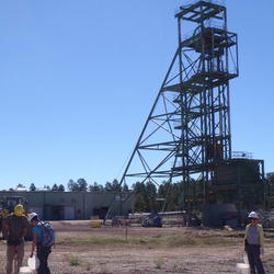
Canyon Mine Sampling
USGS scientists collecting soil samples at Canyon Mine.
USGS scientists collecting soil samples at Canyon Mine.
Science and Products
Life Cycle of Critical Minerals: A Balanced Approach to Meeting Our Nation's Resource Demands
Critical minerals are essential to the Nation’s economy and security. Demand for critical minerals is increasing, and it is essential to balance the societal need for these minerals with efforts to understand the effects of mining on other natural resources and to develop techniques to minimize these effects. The USGS Minerals Resources Life Cycle Integrated Science Team (IST) focuses on the life...
By
Ecosystems Mission Area, Geology, Energy, and Minerals Mission Area, Contaminant Biology, Environmental Health Program, Mineral Resources Program, Toxic Substances Hydrology, Columbia Environmental Research Center, Geology, Energy & Minerals Science Center, Geology, Geophysics, and Geochemistry Science Center, Geology, Minerals, Energy, and Geophysics Science Center
Minerals Resources Life Cycle Integrated Science Team
The Minerals Resources Life Cycle Integrated Science Team focuses on contaminant exposures in the environment that might originate from mineral resource activities including, transportation, storage, extraction and waste management. Perceived health risks to humans and other organisms will be distinguished from actual risks, if any. If actual risks are identified the science produced by this team...
Upper Arkansas River Basin Toxics and Synoptic Studies
From 1986 to 2001, the Upper Arkansas Toxics Project focused on metal transport in streams affected by mining. Studies were conducted to quantify the physical, chemical, and biological processes affecting trace metal fate and transport.
Gold King Mine release (2015): USGS water-quality data and activities
On August 5, 2015, U.S. EPA was conducting an investigation of the Gold King Mine near Silverton, Colorado. While excavating as part of the investigation, water began leaking from the mine tunnel, and about three million gallons of water and sediment were released into Cement Creek, a tributary of the Animas River. The USGS provided pre- and post-release water-quality and streamflow data from...
Watershed Contamination from Hard Rock Mining
Since 1986, the USGS Hard-Rock Mining Toxic-Substances Hydrology Project has focused on metal transport in streams affected by mining. Tracer-injection studies in St. Kevin Gulch, near Leadville, Colorado, helped the USGS design methods to characterize loading from mining activities on a watershed scale. Tracer-injection studies were done in 1995, in support of the planning needs of ederal Land...
U.S. Geological Survey Develops Approach to Assess Baseline Chemical and Radiological Conditions Prior to Uranium Mining near Grand Canyon National Park
U.S. Geological Survey (USGS) scientists developed an approach and collected baseline data to quantitatively assess offsite migration of mine-related contaminants and to identify critical contaminant exposure pathways that could result from uranium mining activities in the Grand Canyon region.
Metal Concentrations and Loads in Leavenworth Creek, Colorado
Metal loading from abandoned mines and groundwater in Leavenworth Creek causes aquatic life water-quality standards to be exceeded at the mouth of Leavenworth Creek.
Upper Arkansas Toxic-Substances Hydrology
Since 1986, the USGS Hard-Rock Mining Toxic-Substances Hydrology Project has focused on metal transport in streams affected by mining. Tracer-injection studies in St. Kevin Gulch, near Leadville, Colorado, helped the USGS design methods to characterize loading from mining activities on a watershed scale. Tracer-injection studies were done in 1995, in support of the planning needs of ederal Land...
Sources of Metal Loading to the Lake Fork from Turquoise Lake to the confluence with the Arkansas River
The Lake Fork emerges from the outlet of Turquoise Lake at the Sugarloaf dam and flows approximately 5 miles before joining the upper Arkansas River. The first reach of the Lake Fork downstream from the dam is affected by drainage from abandoned mines in the Sugarloaf mining district. Whereas remediation of some of the mine sites has been initiated, Federal Land holders are interested in assessing...
Effects of Fluvial Tailings Deposits on Receiving Waters in the Upper Arkansas River Basin, Lake County, Colorado
Fluvial tailings deposits stored in the floodplain of the upper Arkansas River represent a potential nonpoint source of contamination to surface and ground waters. The U.S. Geological Survey has been cooperating with the U.S. Environmental Protection Agency to monitor a lowcost, insitu remediation technique for the deposits.
Upper Animas River Basin Abandoned Mine Lands Initiative
The USGS Abandoned Mine Lands Initiative (AMLI) is developing and demonstrating scientific knowledge and technologies that will help Federal land management agencies clean up contamination in areas near abandoned hardrock mines across the Nation. The Initiative is being conducted in two pilot watersheds, the Upper Animas River Basin in Colorado and the Boulder River watershed in Montana, where the...
View Down Kanab Creek
View looking south down Kanab Creek toward the Grand Canyon and the Colorado River in the distance.
View looking south down Kanab Creek toward the Grand Canyon and the Colorado River in the distance.
Canyon Mine Sampling
USGS scientists collecting soil samples at Canyon Mine.
USGS scientists collecting soil samples at Canyon Mine.